Boltonville, Wisconsin
| Boltonville, Wisconsin | |
|---|---|
| Unincorporated community | |
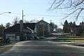
 Looking east at downtown Boltonville | |
 Boltonville, Wisconsin  Boltonville, Wisconsin | |
| Coordinates: 43°31′38″N 88°06′02″W / 43.52722°N 88.10056°WCoordinates: 43°31′38″N 88°06′02″W / 43.52722°N 88.10056°W | |
| Country | United States |
| State | Wisconsin |
| County | Washington |
| Elevation | 873 ft (266 m) |
| Time zone | UTC-6 (Central (CST)) |
| • Summer (DST) | UTC-5 (CDT) |
| Area code(s) | 262 |
| GNIS feature ID | 1562045[1] |
Boltonville is an unincorporated community located in the town of Farmington, Washington County, Wisconsin, United States.[1]
Historical places
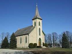
Just south of Boltonville is the St. John of God Roman Catholic Church, Convent, and School, a church listed on the National Register of Historic Places.
Images
 Looking west in downtown Boltonville
 Fire department
 Looking north at Boltonville
 Looking north at the sign for Boltonville on WIS 28
References
| Wikimedia Commons has media related to Boltonville, Wisconsin. |
Municipalities and communities of Washington County, Wisconsin, United States | ||
|---|---|---|
| Cities | 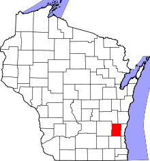 | |
| Villages | ||
| Towns | ||
| CDP | ||
| Unincorporated communities |
| |
| Footnotes | ‡This populated place also has portions in an adjacent county or counties | |
This article is issued from
Wikipedia.
The text is licensed under Creative Commons - Attribution - Sharealike.
Additional terms may apply for the media files.