Cassville, Wisconsin
| Cassville, Wisconsin | |
|---|---|
| Village | |
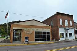 Cassville post office | |
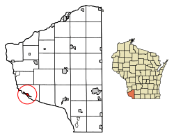 Location of Cassville in Grant County, Wisconsin. | |
| Coordinates: 42°42′55.34″N 90°59′26.08″W / 42.7153722°N 90.9905778°WCoordinates: 42°42′55.34″N 90°59′26.08″W / 42.7153722°N 90.9905778°W | |
| Country | United States |
| State | Wisconsin |
| County | Grant |
| Area[1] | |
| • Total | 0.06 sq mi (0.15 km2) |
| • Land | 0.06 sq mi (0.15 km2) |
| • Water | 0.00 sq mi (0.00 km2) |
| Elevation[2] | 955 ft (291 m) |
| Population (2010)[3] | |
| • Total | 947 |
| • Estimate (2016)[4] | 920 |
| • Density | 15,862.07/sq mi (6,093.40/km2) |
| Time zone | UTC-6 (Central (CST)) |
| • Summer (DST) | UTC-5 (CDT) |
| Area code(s) | 608 |
| FIPS code | 55-13075[5] |
| GNIS feature ID | 1582927[2] |
Cassville is a village in Grant County, Wisconsin, United States. The population was 947 at the 2010 census. The village is located along the Mississippi River within the Town of Cassville.
Geography
Cassville is located at 42°42′55.34″N 90°59′26.08″W / 42.7153722°N 90.9905778°W.[6]
According to the United States Census Bureau, the village has a total area of 0.98 square miles (2.54 km2), of which, 0.97 square miles (2.51 km2) of it is land and 0.01 square miles (0.03 km2) is water.[7]
Demographics
| Historical population | |||
|---|---|---|---|
| Census | Pop. | %± | |
| 1870 | 551 | — | |
| 1880 | 610 | 10.7% | |
| 1890 | 886 | 45.2% | |
| 1900 | 979 | 10.5% | |
| 1910 | 890 | −9.1% | |
| 1920 | 899 | 1.0% | |
| 1930 | 875 | −2.7% | |
| 1940 | 956 | 9.3% | |
| 1950 | 984 | 2.9% | |
| 1960 | 1,290 | 31.1% | |
| 1970 | 1,343 | 4.1% | |
| 1980 | 1,270 | −5.4% | |
| 1990 | 1,144 | −9.9% | |
| 2000 | 1,085 | −5.2% | |
| 2010 | 947 | −12.7% | |
| Est. 2016 | 920 | [4] | −2.9% |
| U.S. Decennial Census[8] | |||
2010 census
As of the census[3] of 2010, there were 947 people, 428 households, and 277 families residing in the village. The population density was 976.3 inhabitants per square mile (377.0/km2). There were 582 housing units at an average density of 600.0 per square mile (231.7/km2). The racial makeup of the village was 98.6% White, 0.1% Native American, 0.2% Asian, 0.2% from other races, and 0.8% from two or more races. Hispanic or Latino of any race were 0.3% of the population.
There were 428 households of which 24.5% had children under the age of 18 living with them, 50.5% were married couples living together, 10.7% had a female householder with no husband present, 3.5% had a male householder with no wife present, and 35.3% were non-families. 31.8% of all households were made up of individuals and 17.3% had someone living alone who was 65 years of age or older. The average household size was 2.21 and the average family size was 2.75.
The median age in the village was 48.3 years. 20.8% of residents were under the age of 18; 7.3% were between the ages of 18 and 24; 17% were from 25 to 44; 31.2% were from 45 to 64; and 23.7% were 65 years of age or older. The gender makeup of the village was 49.0% male and 51.0% female.
2000 census
As of the census[5] of 2000, there were 1,085 people, 488 households, and 302 families residing in the village. The population density was 1,005.1 people per square mile (387.9/km²). There were 572 housing units at an average density of 529.9 per square mile (204.5/km²). The racial makeup of the village was 99.17% White, 0.46% Native American, 0.09% from other races, and 0.28% from two or more races. 0.37% of the population were Hispanic or Latino of any race.
There were 488 households out of which 26.2% had children under the age of 18 living with them, 49.4% were married couples living together, 9.2% had a female householder with no husband present, and 38.1% were non-families. 35.2% of all households were made up of individuals and 20.9% had someone living alone who was 65 years of age or older. The average household size was 2.22 and the average family size was 2.82.
In the village, the population was spread out with 24.1% under the age of 18, 5.3% from 18 to 24, 22.9% from 25 to 44, 23.8% from 45 to 64, and 24.0% who were 65 years of age or older. The median age was 42 years. For every 100 females, there were 90.7 males. For every 100 females age 18 and over, there were 87.0 males.
The median income for a household in the village was $28,179, and the median income for a family was $35,625. Males had a median income of $29,271 versus $17,014 for females. The per capita income for the village was $16,010. About 10.3% of families and 14.6% of the population were below the poverty line, including 13.1% of those under age 18 and 23.3% of those age 65 or over.
Economy
The Nelson Dewey Generating Station and the E. J. Stoneman Generating Station are in Cassville. Both closed in 2015.[9]
Transportation
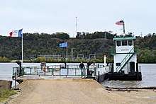
From late spring through early fall, the Cassville Car Ferry connects Cassville with rural Clayton County, Iowa, near Millville. (During periods of high water, the ferry may not operate).[10]
History
The village was named after Lewis Cass, the governor of Michigan Territory from 1813-1831. The name has been used by the community since at least 1828, when the post office was established by Allen Hill.[11]
Notable people
- Joseph Bock, soldier and member of the Wisconsin State Assembly
- Nelson Dewey, first Wisconsin Governor 1848-1852
- Patrick H. Kelly, educator and member of the Wisconsin State Assembly
References
- ↑ "2016 U.S. Gazetteer Files". United States Census Bureau. Retrieved Jul 14, 2017.
- 1 2 "US Board on Geographic Names". United States Geological Survey. 2007-10-25. Retrieved 2008-01-31.
- 1 2 "American FactFinder". United States Census Bureau. Retrieved 2012-11-18.
- 1 2 "Population and Housing Unit Estimates". Retrieved June 9, 2017.
- 1 2 "American FactFinder". United States Census Bureau. Archived from the original on 2013-09-11. Retrieved 2008-01-31.
- ↑ "US Gazetteer files: 2010, 2000, and 1990". United States Census Bureau. 2011-02-12. Retrieved 2011-04-23.
- ↑ "US Gazetteer files 2010". United States Census Bureau. Archived from the original on 2012-07-14. Retrieved 2012-11-18.
- ↑ "Census of Population and Housing". Census.gov. Archived from the original on April 22, 2013. Retrieved June 4, 2015.
- ↑ Reber, Craig (January 3, 2016). "Cassville plants power down in 2015". Telegraph Herald. Dubuque, Iowa.
- ↑ "Cassville, Wisconsin". cassville.org. Retrieved 2017-05-16.
- ↑ Callary, Edward. Place Names of Wisconsin. Madison, WI: University of Wisconsin Press. p. 52. ISBN 978-0-299-30964-0.
External links
- Cassville, Wisconsin official website
- Sanborn fire insurance maps: 1894 1900 1912
Municipalities and communities of Grant County, Wisconsin, United States | ||
|---|---|---|
| Cities | 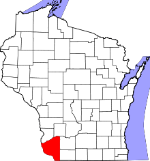 | |
| Villages | ||
| Towns |
| |
| CDPs | ||
| Unincorporated communities |
| |
| Ghost town/neighborhood | ||
| Footnotes | ‡This populated place also has portions in an adjacent county or counties | |