Nekoosa, Wisconsin
| Nekoosa, Wisconsin | |
|---|---|
| City | |
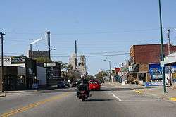 Looking west in downtown Nekoosa | |
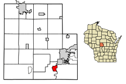 Location of Nekoosa in Wood County, Wisconsin. | |
| Coordinates: 44°19′9″N 89°54′00″W / 44.31917°N 89.90000°W | |
| Country | United States |
| State | Wisconsin |
| County | Wood |
| Government | |
| • Mayor | Alan K. Marcoux[1] |
| Area[2] | |
| • Total | 1.44 sq mi (3.74 km2) |
| • Land | 1.44 sq mi (3.74 km2) |
| • Water | 0.00 sq mi (0.00 km2) |
| Elevation[3] | 951 ft (290 m) |
| Population (2010)[4] | |
| • Total | 2,580 |
| • Estimate (2016)[5] | 2,443 |
| • Density | 1,694.17/sq mi (653.99/km2) |
| Time zone | UTC-6 (Central (CST)) |
| • Summer (DST) | UTC-5 (CDT) |
| ZIP codes | 54457 |
| Area code(s) | 715 & 534 |
| FIPS code | 55-55875[6] |
| GNIS feature ID | 1570148[3] |
Nekoosa is a city in Wood County, Wisconsin, United States. The population was 2,580 at the 2010 census.
History
Nekoosa was platted in 1893.[7] The name "Nekoosa" derives from the Ho-Chunk word, "Nįįkuusra", "Nakrusa", or "Nįkusara" which translates to "running water."[8][9] A post office has been in operation at Nekoosa since 1893.[10]
Geography
Nekoosa is located at 44°19′09″N 89°54′00″W / 44.319081°N 89.899937°WCoordinates: 44°19′09″N 89°54′00″W / 44.319081°N 89.899937°W (44.319081, -89.899937).[11]
According to the United States Census Bureau, the city has a total area of 3.39 square miles (8.78 km2), of which, 3.38 square miles (8.75 km2) is land and 0.01 square miles (0.03 km2) is water.[12]
Demographics
| Historical population | |||
|---|---|---|---|
| Census | Pop. | %± | |
| 1900 | 745 | — | |
| 1910 | 1,570 | 110.7% | |
| 1920 | 1,639 | 4.4% | |
| 1930 | 2,005 | 22.3% | |
| 1940 | 2,212 | 10.3% | |
| 1950 | 2,352 | 6.3% | |
| 1960 | 2,515 | 6.9% | |
| 1970 | 2,409 | −4.2% | |
| 1980 | 2,519 | 4.6% | |
| 1990 | 2,557 | 1.5% | |
| 2000 | 2,590 | 1.3% | |
| 2010 | 2,580 | −0.4% | |
| Est. 2016 | 2,443 | [5] | −5.3% |
| U.S. Decennial Census[13] | |||
2010 census
As of the census[4] of 2010, there were 2,580 people, 1,065 households, and 688 families residing in the city. The population density was 763.3 inhabitants per square mile (294.7/km2). There were 1,135 housing units at an average density of 335.8 per square mile (129.7/km2). The racial makeup of the city was 93.3% White, 0.8% African American, 1.4% Native American, 0.5% Asian, 1.8% from other races, and 2.2% from two or more races. Hispanic or Latino of any race were 3.4% of the population.
There were 1,065 households of which 33.1% had children under the age of 18 living with them, 46.4% were married couples living together, 13.4% had a female householder with no husband present, 4.8% had a male householder with no wife present, and 35.4% were non-families. 30.2% of all households were made up of individuals and 15.5% had someone living alone who was 65 years of age or older. The average household size was 2.40 and the average family size was 2.98.
The median age in the city was 39.4 years. 26.5% of residents were under the age of 18; 7.9% were between the ages of 18 and 24; 23.8% were from 25 to 44; 23.6% were from 45 to 64; and 18.1% were 65 years of age or older. The gender makeup of the city was 47.8% male and 52.2% female.
2000 census
As of the census[6] of 2000, there were 2,590 people, 987 households, and 702 families residing in the city. The population density was 763.5 people per square mile (295.0/km²). There were 1,063 housing units at an average density of 313.4 per square mile (121.1/km²). The racial makeup of the city was 96.72% White, 0.12% African American, 1.27% Native American, 0.31% Asian, 0.97% from other races, and 0.62% from two or more races. Hispanic or Latino of any race were 1.81% of the population.
There were 987 households out of which 36.3% had children under the age of 18 living with them, 55.2% were married couples living together, 12.9% had a female householder with no husband present, and 28.8% were non-families. 24.8% of all households were made up of individuals and 13.3% had someone living alone who was 65 years of age or older. The average household size was 2.55 and the average family size was 3.05.
In the city, the population was spread out with 27.6% under the age of 18, 7.8% from 18 to 24, 27.2% from 25 to 44, 20.6% from 45 to 64, and 16.8% who were 65 years of age or older. The median age was 37 years. For every 100 females, there were 88.6 males. For every 100 females age 18 and over, there were 83.5 males.
The median income for a household in the city was $39,375, and the median income for a family was $44,583. Males had a median income of $36,308 versus $22,361 for females. The per capita income for the city was $17,063. About 6.7% of families and 9.7% of the population were below the poverty line, including 10.6% of those under age 18 and 12.0% of those age 65 or over.
Economy
Employment in Nekoosa has long been dominated by paper making. The Nekoosa Paper Company, incorporated in 1893, constructed a mill on the Wisconsin River. In 1908 it merged with a paper company in nearby Port Edwards, forming the Nekoosa Edwards Paper Company, or NEPCO.[14][15] In 1970 NEPCO merged with the Great Northern Paper Company, forming Great Northern Nekoosa Corporation, or GNN, which was purchased in a hostile takeover by Georgia-Pacific in 1990.[16][17] In 2001 the mill was sold to Canadian paper company Domtar.[18][19][20]
The Nekoosa mill was the original home of a cutting-edge paper machine first shown at the 1893 Columbian Exhibition. The machine was moved in 1923 to a sister mill in Port Edwards.[21] Stock certificates from NEPCO[22][23] and GNN[24] are popular scripophily items.
Education
Nekoosa has four schools: Humke Elementary School, Alexander Middle School, Nekoosa High School, and Nekoosa Academy. A new school designed specifically to teach Ho-Chunk heritage and history has been added to the district.
Notable people
- Chief Oshkosh, Native American leader
- Ed 'Strangler' Lewis, professional wrestler
- Edgar Manske, professional football player
- Frederick C. Peerenboom, radio
- John M. Potter, Wisconsin State Senator
Images
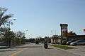 Looking south in downtown Nekoosa
 Sign on WIS 73
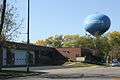 Police station and water tower
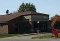 Post office
References
- ↑ http://nekoosawi.com/?page_id=14
- ↑ "2016 U.S. Gazetteer Files". United States Census Bureau. Retrieved Jul 14, 2017.
- 1 2 "US Board on Geographic Names". United States Geological Survey. 2007-10-25. Retrieved 2008-01-31.
- 1 2 "American FactFinder". United States Census Bureau. Retrieved 2012-11-18.
- 1 2 "Population and Housing Unit Estimates". Retrieved June 9, 2017.
- 1 2 "American FactFinder". United States Census Bureau. Retrieved 2008-01-31.
- ↑ Rudolph, Robert S. (1970). Wood County Place Names (PDF). The University of Wisconsin Press. p. 56.
- ↑ "A history of the origin of the place names connected with the Chicago & North Western and Chicago, St. Paul, Minneapolis & Omaha railways", page 106, by William H. Stennett, Edition 2, Published 1908, Original from Harvard University, Digitized July 30, 2008 for Google Books, 201 pages.
- ↑ "Locations". Hoocąk Waaziija Haci Language Division, A Division of The Ho-Chunk Nation. Retrieved 2014-04-06.
- ↑ "Post Offices". Jim Forte Postal History. Retrieved 27 March 2018.
- ↑ "US Gazetteer files: 2010, 2000, and 1990". United States Census Bureau. 2011-02-12. Retrieved 2011-04-23.
- ↑ "US Gazetteer files 2010". United States Census Bureau. Archived from the original on 2012-01-24. Retrieved 2012-11-18.
- ↑ "Census of Population and Housing". Census.gov. Retrieved June 4, 2015.
- ↑ J. Marshall Buehler. The Nekoosa Story: A Commemorative History of Nekoosa Papers Inc., Port Edwards, Wis.: Nekoosa Papers, 1987. 169p. HD 9829 .N45 B84 1987.
- ↑ Wisconsin Historical Society entry for Lewis Miller Alexander (1858-1931)
- ↑ "Nekoosa seeks buyer to avoid hostile bid", New York Times, February 14, 1990.
- ↑ "Nekoosa to Weigh New $3.8-Billion Georgia-Pacific Bid - Takeovers: The paper products firm earlier rejected a $58-per-share offer. Now it will discuss a sweetened deal" LA Times, November 20, 1989
- ↑ Domtar corporate web site description
- ↑ "Great Northern Nekoosa Corporation", Lehman Brothers Collection
- ↑ Great Northern Nekoosa Corporation Stock Certificate & History
- ↑ The Beloit Iron Works Columbian Machine
- ↑ Nekoosa-Edwards Paper Company Stock Certificate
- ↑ Great Northern Nekoosa Corporation Stock Certificate
- ↑ Great Northern Nekoosa Paper Corporation Stock Certificate
External links
| Wikimedia Commons has media related to Nekoosa, Wisconsin. |
- City of Nekoosa official web site
- Nekoosa Public Schools
- Historic Pointe Basse
- Sanborn fire insurance maps: 1895 1902 1909
- Plat maps of Nekoosa: 1909 1928
Municipalities and communities of Wood County, Wisconsin, United States | ||
|---|---|---|
| Cities | 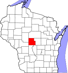 | |
| Villages | ||
| Towns | ||
| CDPs | ||
| Unincorporated communities | ||
| Indian reservation | ||
| Footnotes | ‡This populated place also has portions in an adjacent county or counties | |