List of counties in Idaho
| Counties of Idaho | |
|---|---|
 | |
| Location | State of Idaho |
| Number | 44 |
| Populations | 982 (Clark) – 392,365 (Ada) |
| Areas | 408 square miles (1,060 km2) (Payette) – 8,485 square miles (21,980 km2) (Idaho) |
| Government | County government |
| Subdivisions | cities, towns, townships, unincorporated communities, indian reservations, census designated place |
There are 44 counties in the U.S. state of Idaho.
The Idaho Territory was organized in March 1863, and Owyhee County was the first county in the territory to be organized, in December of that year. Oneida County was organized in January 1864, while Missoula County was adopted the same month, before becoming part of the new Montana Territory in May. Shoshone, Nez Perce, Idaho and Boise Counties were recognized in February 1864; Alturas County was organized the same month. In December 1864, Kootenai and Ada Counties were created; Lah-Toh County was also created at this time but was abolished in 1867.
Idaho's present-day boundaries were established in 1868, and Lemhi County was created the following year. By the time Idaho was admitted to the Union as the 43rd state in 1890, a further eight counties had been created, bringing the total to 18. After Canyon, Fremont and Bannock Counties had been created, Alturas and Logan Counties were merged to form Blaine County in March 1895; Lincoln County was formed out of Blaine County later the same month. Bonner and Twin Falls Counties were created in 1907, before a further 21 counties were created between 1911 and 1919, bringing the total to the present-day 44.
Since 1945, each county has used a code on its license plates that features the first letter of the county's name. Where the names of two or more counties start with the same letter, in each of these counties the letter is preceded by a number indicating that county's order in the alphabetical list. For instance, the four counties beginning with 'L' in alphabetical order are Latah, Lemhi, Lewis and Lincoln; the codes for these counties are thus 1L, 2L, 3L and 4L respectively. Elmore, Idaho, Kootenai, Nez Perce, Shoshone, Valley, and Washington Counties are the only ones in the state with their respective first letters; in these counties, the letter alone serves as the code.
Alphabetical list
| County |
FIPS code[1] | County seat[2] | Established[2] | Origin[3] | License Plate Designator[4] | Etymology [5] |
Population[2][6] | Area[2][6] | Map |
|---|---|---|---|---|---|---|---|---|---|
| Ada County | 001 | Boise | 1864 | Boise County | 1A | Ada Riggs, daughter of H. C. Riggs, a member of the Idaho Territorial Legislature. | 392,365 | 1,055 sq mi (2,732 km2) | 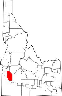 |
| Adams County | 003 | Council | 1911 | Washington County | 2A | John Adams (1735-1826), second President of the United States (1797-1801). | 3,976 | 1,365 sq mi (3,535 km2) | 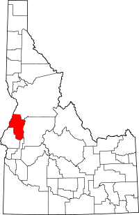 |
| Bannock County | 005 | Pocatello | 1893 | Bingham County | 1B | Bannock Native American tribe. | 82,839 | 1,113 sq mi (2,883 km2) | 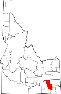 |
| Bear Lake County | 007 | Paris | 1875 | Oneida County | 2B | Bear Lake on the Utah/Idaho border. | 5,986 | 971 sq mi (2,515 km2) | 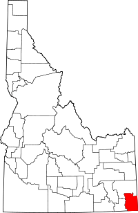 |
| Benewah County | 009 | St. Maries | 1915 | Kootenai County | 3B | Ben'wah, chief of the Coeur d'Alene Tribe | 9,285 | 776 sq mi (2,010 km2) | 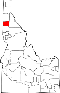 |
| Bingham County | 011 | Blackfoot | 1885 | Oneida County | 4B | Henry H. Bingham (1841-1912), a general in the American Civil War and a U.S. Congressman from Pennsylvania. | 45,607 | 2,095 sq mi (5,426 km2) | 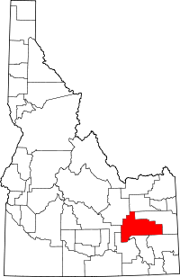 |
| Blaine County | 013 | Hailey | 1895 | Alturas and Logan Counties | 5B | James G. Blaine (1830-1893), United States Secretary of State (1881, 1889-1892). | 21,376 | 2,645 sq mi (6,851 km2) | 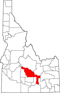 |
| Boise County | 015 | Idaho City | 1864 | original county | 6B | Boise River | 7,028 | 1,902 sq mi (4,926 km2) | 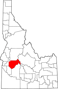 |
| Bonner County | 017 | Sandpoint | 1907 | Kootenai County | 7B | Edwin L. Bonner, originator of an 1864 ferry service on the Kootenai River. | 40,877 | 1,738 sq mi (4,501 km2) | 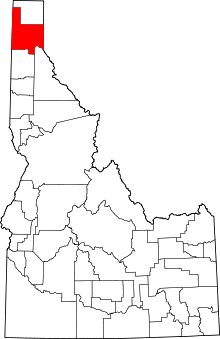 |
| Bonneville County | 019 | Idaho Falls | 1911 | Bingham County | 8B | Benjamin Bonneville (1796-1878), a French-born explorer of the West. | 104,234 | 1,869 sq mi (4,841 km2) | 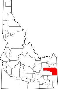 |
| Boundary County | 021 | Bonners Ferry | 1915 | Bonner County | 9B | Borders Canada on the north. | 10,972 | 1,269 sq mi (3,287 km2) | 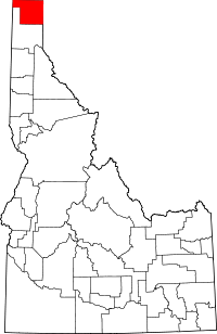 |
| Butte County | 023 | Arco | 1917 | Bingham, Blaine, and Jefferson Counties | 10B | Buttes rising from the Snake River Plain. | 2,891 | 2,233 sq mi (5,783 km2) | 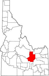 |
| Camas County | 025 | Fairfield | 1917 | Blaine County | 1C | Camassia, a plant species important as a food source among Native Americans and early settlers. | 1,117 | 1,075 sq mi (2,784 km2) | 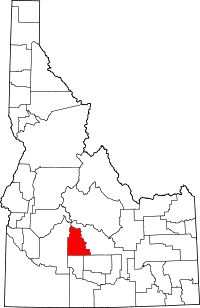 |
| Canyon County | 027 | Caldwell | 1892 | Ada County | 2C | Disputed, either a canyon of the Boise River near Caldwell or a canyon of the Snake River which forms part of the county's boundary. | 188,923 | 590 sq mi (1,528 km2) | 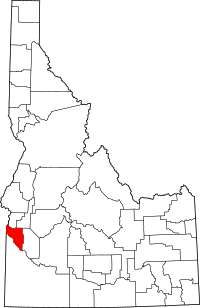 |
| Caribou County | 029 | Soda Springs | 1919 | Bannock County | 3C | Caribou Mountains | 6,963 | 1,766 sq mi (4,574 km2) | 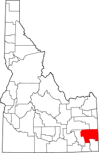 |
| Cassia County | 031 | Burley | 1879 | Owyhee County | 4C | Disputed, either Cassia Creek or a member of the Mormon Battalion, James John Cazier. | 22,952 | 2,567 sq mi (6,648 km2) | 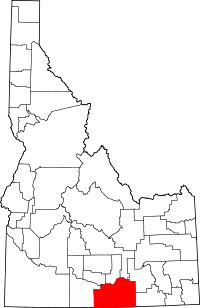 |
| Clark County | 033 | Dubois | 1919 | Fremont County | 5C | Sam K. Clark, early settler and a member of the Idaho Senate. | 982 | 1,765 sq mi (4,571 km2) | 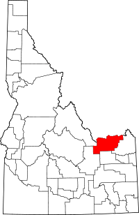 |
| Clearwater County | 035 | Orofino | 1911 | Nez Perce County | 6C | Clearwater River | 8,761 | 2,462 sq mi (6,377 km2) | 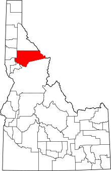 |
| Custer County | 037 | Challis | 1881 | Alturas and Lemhi Counties | 7C | General Custer mine, named after George Armstrong Custer (1839-1876), United States Army general. | 4,368 | 4,926 sq mi (12,758 km2) | 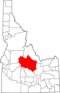 |
| Elmore County | 039 | Mountain Home | 1889 | Alturas County | E | Ida Elmore mines, locally noted for gold and silver production in the 1860s. | 27,038 | 3,078 sq mi (7,972 km2) | 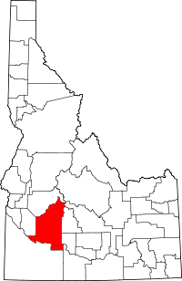 |
| Franklin County | 041 | Preston | 1913 | Oneida County | 1F | Franklin D. Richards (1821-1899), early LDS Church apostle. | 12,786 | 666 sq mi (1,725 km2) | 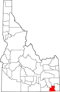 |
| Fremont County | 043 | Saint Anthony | 1893 | Bingham County | 2F | John C. Frémont (1813-1890), an explorer of the West. | 13,242 | 1,867 sq mi (4,836 km2) | 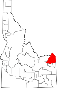 |
| Gem County | 045 | Emmett | 1915 | Boise and Canyon Counties | 1G | State nickname of "Gem State." | 16,719 | 563 sq mi (1,458 km2) | 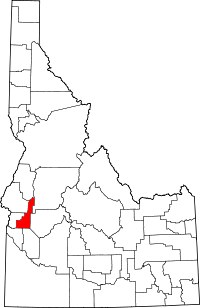 |
| Gooding County | 047 | Gooding | 1913 | Lincoln County | 2G | Frank R. Gooding (1859-1928), seventh Governor of Idaho (1905-1909), U.S. Senator (1921-1928). | 15,464 | 731 sq mi (1,893 km2) | 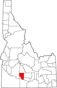 |
| Idaho County | 049 | Grangeville | 1864 | original county | I | Columbia River steamship Idaho launched in 1860. Name predates both Idaho Territory and the State of Idaho. | 16,267 | 8,485 sq mi (21,976 km2) | 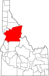 |
| Jefferson County | 051 | Rigby | 1913 | Fremont County | 1J | Thomas Jefferson (1743-1826), third President of the United States (1801-1809). | 26,140 | 1,095 sq mi (2,836 km2) | 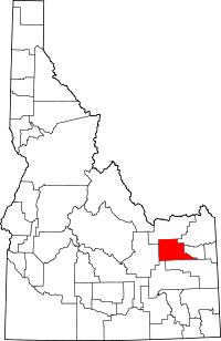 |
| Jerome County | 053 | Jerome | 1919 | Gooding and Lincoln Counties | 2J | Disputed, either North Side Irrigation Project developer Jerome Hill, his son-in-law Jerome Kuhn, or his grandson Jerome Kuhn, Jr. | 22,374 | 600 sq mi (1,554 km2) | 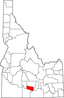 |
| Kootenai County | 055 | Coeur d'Alene | 1864 | Nez Perce County | K | Kootenai Native American tribe. | 138,494 | 1,245 sq mi (3,225 km2) | 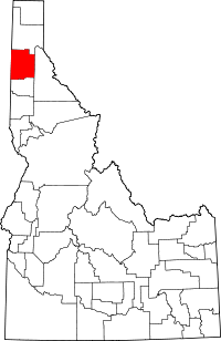 |
| Latah County | 057 | Moscow | 1888 | Nez Perce County | 1L | Latah Creek, Nez Perce for "the place of pine trees and sestle." | 37,244 | 1,077 sq mi (2,789 km2) | 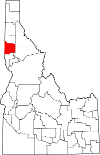 |
| Lemhi County | 059 | Salmon | 1869 | Idaho County | 2L | Limhi, king of the Nephites according to the Book of Mormon. | 7,936 | 4,564 sq mi (11,821 km2) | 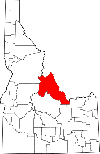 |
| Lewis County | 061 | Nezperce | 1911 | Nez Perce County | 3L | Meriwether Lewis (1774-1809), a leader of the Lewis and Clark Expedition. | 3,821 | 479 sq mi (1,241 km2) | 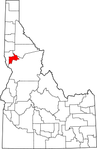 |
| Lincoln County | 063 | Shoshone | 1895 | Blaine County | 4L | Abraham Lincoln (1809-1865), sixteenth President of the United States (1861-1865). Idaho Territory was founded under Lincoln's administration. | 5,208 | 1,206 sq mi (3,124 km2) | 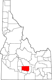 |
| Madison County | 065 | Rexburg | 1913 | Fremont County | 1M | James Madison (1751-1836), fourth President of the United States (1809-1817). | 37,536 | 472 sq mi (1,222 km2) | 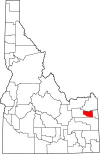 |
| Minidoka County | 067 | Rupert | 1913 | Lincoln County | 2M | Disputed Native American origin, either Lakota for "a fountain or spring of water" or Shoshoni for "broad expanse." | 20,069 | 760 sq mi (1,968 km2) | 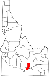 |
| Nez Perce County | 069 | Lewiston | 1864 | original county | N | The Nez Perce, a Native American tribe. | 39,265 | 849 sq mi (2,199 km2) | 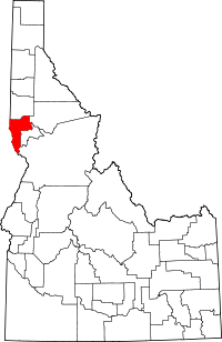 |
| Oneida County | 071 | Malad City | 1864 | original county | 1O | Oneida Lake in New York state, where many early settlers were from. | 4,286 | 1,200 sq mi (3,108 km2) | 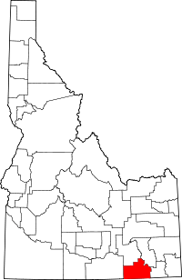 |
| Owyhee County | 073 | Murphy | 1863 | original county | 2O | Alternate spelling of Hawaii. Hawaiian fur trappers explored the area in 1819 and 1820. | 11,526 | 7,678 sq mi (19,886 km2) | 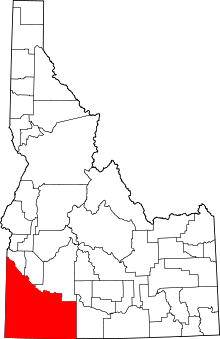 |
| Payette County | 075 | Payette | 1917 | Canyon County | 1P | Francois Payette (1793-1844?), Canadian-born fur trader and early settler. | 22,623 | 408 sq mi (1,057 km2) | 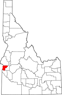 |
| Power County | 077 | American Falls | 1913 | Bingham, Blaine, and Oneida Counties | 2P | The American Falls Power Plant | 7,817 | 1,406 sq mi (3,642 km2) | 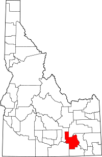 |
| Shoshone County | 079 | Wallace | 1864 | original county | S | Shoshone Native American tribe. | 12,765 | 2,634 sq mi (6,822 km2) | 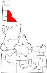 |
| Teton County | 081 | Driggs | 1915 | Bingham, Fremont, and Madison Counties | 1T | Teton Range in Wyoming. | 10,170 | 450 sq mi (1,165 km2) | 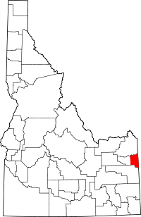 |
| Twin Falls County | 083 | Twin Falls | 1907 | Cassia County | 2T | Twin Falls waterfall on the Snake River. | 77,230 | 1,925 sq mi (4,986 km2) | 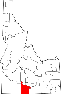 |
| Valley County | 085 | Cascade | 1917 | Boise and Idaho Counties | V | Long Valley located in the county. | 9,862 | 3,733 sq mi (9,668 km2) | 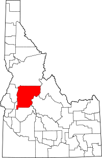 |
| Washington County | 087 | Weiser | 1879 | Ada County | W | George Washington (1732-1799), first President of the United States (1789-1797). | 10,198 | 1,456 sq mi (3,771 km2) | 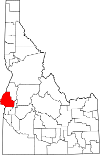 |
Remember the counties
In some fourth grade classrooms, students memorize the counties with the following poem:
Counties of Idaho Poem
Ada is first with our capital town,
Adams’ Seven Devils go straight up and down.
Then ten counties start with B;
Bannock, Bear Lake, Benewah three;
Bingham, Blaine, Boise, Bonner,
Bonneville, Boundary, Butte make ten.
Then the next seven start with C:
Camas, Canyon, Caribou three.
Cassia, Clark, Clearwater, Custer,
Are the Idaho C’s we can muster.
Elmore, Franklin, Fremont, Gem,
Gooding and Idaho don’t forget them.
Flatlands of Jefferson,
Potatoes of Jerome,
Kootenai, Latah, we’re almost home.
Lemhi and Lewis,
Hurry, hurry, hurry!
Lincoln with its ice caves
Very very burry.
Madison, Minidoka, Nez Perce;
Our Indian accent grows worse and worse.
Oneida, Owyhee, a little faster please
Payette and Power are the only Ps.
Shoshone, Teton, Twin Falls, almost done,
Valley County and Washington.
Author unknown
Defunct Idaho counties
- Alturas County: A huge county in south-central Idaho that was formed in 1864, but split up and abolished in 1895.
- Lah-Toh County: A county in northern Idaho that was formed in 1864, but it was abolished a short time later in 1867.
- Logan County: Formed by a partition of Alturas County in 1889, but it was shortly abolished in 1895.
References
- ↑ "EPA County FIPS Code Listing". EPA.gov. Retrieved 2008-02-23.
- 1 2 3 4 National Association of Counties. "NACo - Find a county". Archived from the original on 2007-10-24. Retrieved 2008-04-26.
- ↑ Hailey, John (1910). The History of Idaho. Press of Syms-York company. pp. 305–307. OCLC 5793481. Retrieved 2008-04-26.
- ↑ "County License Plate Designators List" (PDF). Idaho Transportation Department. Retrieved 2018-06-30.
- ↑ "List of Idaho Counties - Idaho.gov". State of Idaho. Retrieved 2008-07-30.
- 1 2 "Idaho QuickFacts". U.S. Census Bureau. Archived from the original on 2008-05-14. Retrieved 2008-04-23. (2000 Census)