Jordan's Point Historic District
|
Jordan's Point Historic District | |
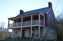 Miller's house at Jordan's Point | |
  | |
| Location | Moses Mill Rd. and the confluence of the Maury River and Woods Creek, Lexington, Virginia |
|---|---|
| Coordinates | 37°47′32″N 79°25′47″W / 37.79222°N 79.42972°WCoordinates: 37°47′32″N 79°25′47″W / 37.79222°N 79.42972°W |
| Area | 15 acres (6.1 ha) |
| Built | 1800 |
| Built by | Jordan, John |
| NRHP reference # | 16000530[1] |
| Added to NRHP | August 15, 2016 |
The Jordan's Point Historic District encompasses a collection of historic industrial resources at Jordan's Point Park in Lexington, Virginia. The area, long a major local crossing point of the Maury River, was developed about 1800 by John Jordan and John Moorhead, who established a sawmill on the site. In 1806 they dammed the river, and then built a cotton mill in 1808. Of this and later industrial activity on the site, only foundation remnants and the millrace remain; surviving structures associated with the development include the miller's house (c. 1815), now a local museum, and a chapel built in 1874.[2]
The district was listed on the National Register of Historic Places in 2016.[1]
See also
References
- 1 2 National Park Service (2010-07-09). "National Register Information System". National Register of Historic Places. National Park Service.
- ↑ "NRHP nomination for Jordan's Point Historic District" (PDF). National Park Service. Retrieved 2017-10-31.


This article is issued from
Wikipedia.
The text is licensed under Creative Commons - Attribution - Sharealike.
Additional terms may apply for the media files.