Batnfjordsøra
| Batnfjordsøra | |
|---|---|
| Village | |
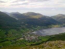 Batnfjordsøra at the end of the Batnfjorden | |
 Batnfjordsøra Location in Møre og Romsdal  Batnfjordsøra Batnfjordsøra (Norway) | |
| Coordinates: 62°53′33″N 07°40′54″E / 62.89250°N 7.68167°ECoordinates: 62°53′33″N 07°40′54″E / 62.89250°N 7.68167°E | |
| Country | Norway |
| Region | Western Norway |
| County | Møre og Romsdal |
| District | Nordmøre |
| Municipality | Gjemnes Municipality |
| Area[1] | |
| • Total | 0.32 km2 (0.12 sq mi) |
| Elevation[2] | 16 m (52 ft) |
| Population (2013)[1] | |
| • Total | 319 |
| • Density | 997/km2 (2,580/sq mi) |
| Time zone | UTC+01:00 (CET) |
| • Summer (DST) | UTC+02:00 (CEST) |
| Post Code | 6631 Batnfjordsøra |
Batnfjordsøra is the administrative centre of Gjemnes Municipality in Møre og Romsdal county, Norway. The village is located at the end of the Batnfjorden at the mouth of the river Batnfjordelva. European Route E39 passes through the village on its way from Molde to Trondheim. The 0.32-square-kilometre (79-acre) village has a population (2013) of 319, which gives the village a population density of 997 inhabitants per square kilometre (2,580/sq mi).[1]
The village of Gjemnes lies about 8 kilometres (5.0 mi) to the northeast, along the north side of the fjord, and Torvikbukt lies about 10 kilometres (6.2 mi) to the northeast along the south side of the fjord. The village of Øre lies about halfway between Torvikbukt and Batnfjordsøra. Heading southwest along E39, you will get to Hjelset and Molde.
References
- 1 2 3 Statistisk sentralbyrå (1 January 2013). "Urban settlements. Population and area, by municipality".
- ↑ "Batnfjordsøra" (in Norwegian). yr.no. Retrieved 2010-11-18.