List of volcanoes in New Zealand
This is a list of active, dormant, and extinct volcanoes in New Zealand.
Kermadec Arc and Havre Trough
North Island
Taupo Volcanic Zone
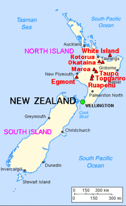
Major volcanoes of New Zealand
Elsewhere
| Name | Elevation | Location | Last eruption | |
| metres | feet | Coordinates | ||
| Auckland volcanic field | 260 | 853 | 36°54′S 174°52′E / 36.90°S 174.87°E | 1421 |
| Bombay Hills | - | - | - | 500,000 years ago |
| Gannet Island | - | - | - | 500,000 years ago |
| Little Barrier Island | 722 | 2360 | - | 1.5 million years ago |
| Kaikohe-Bay of Islands volcanic field | 388 | 1273 | 35°18′S 173°54′E / 35.30°S 173.90°E | 400 ± 300 years |
| Kaitake | - | - | - | 500,000 years ago |
| Kakepuku | 449 | 1473 | 38°04′S 175°15′E | 1.6 million years ago |
| Karioi | 756 | 2480 | 37°30′S 174°29′E / 37.50°S 174.49°E | 2.4 million years ago |
| Manukau volcano | 474 | 1555 | - | 16 million years ago |
| Maungatautari | 797 | 2615 | - | - |
| Mount Pirongia | 962 | 3156 | - | - |
| Paritutu and the Sugar Loaf Islands | 153 | - | - | 1.7 million years ago[4] |
| Poor Knights Islands | - | - | - | 4 million years ago |
| Pouakai | - | - | - | 240,000 years ago |
| Rangitoto Island (part of the Auckland volcanic field) | 260 | 853 | 36°47′13″S 174°51′29″E / 36.78694°S 174.85806°E | 1350 |
| Mount Taranaki or Mount Egmont | 2518 | 8261 | 39°18′S 174°06′E / 39.3°S 174.1°E | 1755 |
| Whangarei volcanic field | 397 | 1302 | 35°45′S 174°16′E / 35.75°S 174.27°E | - |
South Island
| Name | Elevation | Location | Last eruption | |
| meters | feet | Coordinates | ||
| Akaroa Volcano | - | - | 43°48′S 172°57′E / 43.800°S 172.950°E | Miocene |
| Lyttelton Volcano | 919 | 3010 | 43°36′S 172°43′E / 43.600°S 172.717°E | Miocene |
| Mount Horrible (near Timaru) | - | - | 44°23′S 171°3′E / 44.383°S 171.050°E | 2 million years ago [5] |
| Otago Volcano | 680 | 2218 | 45°49′S 170°39′E / 45.817°S 170.650°E | c. 10 million years ago [6] |
Other
| Name | Elevation | Location | Last eruption | |
| meters | feet | Coordinates | ||
| Antipodes Islands | 402 | 1319 | 49°41′S 178°46′E / 49.68°S 178.77°E | Holocene |
| Auckland Island | 650 | 1981 | 50°41′S 166°05′E / 50.69°S 166.08°E | Miocene[7] |
| Pitt Island | 241 | 791 | 44°11′S 176°08′W / 44.18°S 176.13°W | Ancient |
| Mount Dick (Adams Island)[8] | 705 | 2313 | 50°52′28″S 166°4′55″E / 50.87444°S 166.08194°E | - |
| Solander Islands | 330 | 1080 | 46°34′S 166°53′E / 46.567°S 166.883°E | Pleistocene |
Ross Dependency
New Zealand also has de facto administration over Ross Dependency in Antarctica, which contains the following volcanoes:
| Name | Elevation | Location | Last eruption | |
| meters | feet | Coordinates | ||
| Brown Peak | 1500 | 5000 | 67°24′S 164°50′E / 67.40°S 164.83°E | 2001 |
| Buckle Island | 1239 | 4065 | 66°48′S 163°15′E / 66.80°S 163.25°E | 1899 |
| Mount Erebus | 3794 | 12448 | 77°32′S 167°17′E / 77.533°S 167.283°E | 2008 (continuing) |
| Young Island | 1340 | 4396 | 66°25′S 162°27′E / 66.42°S 162.45°E | - |
References
- 1 2 John H. Latter, Edwards F. Lloyd, Ian E.M. Smith, and Simon Nathan. () New Zealand's volcanoes: Kermadec Islands Archived 2010-05-22 at the Wayback Machine.. Volcanic Hazards Working Group, Civil Defence Scientific Advisory Committee.
- ↑ "Okataina: Eruptive History". Global Volcanism Program. Smithsonian Institution.
- ↑ Nairn, I.A.; Beanland, S. (1989). "Geological setting of the 1987 Edgecumbe earthquake, New Zealand". New Zealand Journal of Geology and Geophysics. 32: 1–13. doi:10.1080/00288306.1989.10421383. Retrieved 30 October 2011.
- ↑ Price, R. C; R. B. Stewart; J. D. Woodhead; I. E. M. Smith (1999). "Petrogenesis of High-K Arc Magmas: Evidence from Egmont Volcano, North Island, New Zealand" (PDF). Journal of Petrology. 40 (1): 167&ndash, 197. doi:10.1093/petrology/40.1.167.
- ↑ Wilson, John (2009). "South Canterbury region – Landscape and geology". Te Ara – the Encyclopedia of New Zealand.
- ↑ Bishop, D.G., and Turnbull, I.M. (compilers) (1996). Geology of the Dunedin Area. Lower Hutt, NZ: Institute of Geological & Nuclear Sciences. ISBN 0-478-09521-X.
- ↑ Adams, C.J (1983). "Age of the volcanoes and granite basements of the Auckland Islands, Southwest Pacific". New Zealand Journal of Geology and Geophysics. 26: 227–237. doi:10.1080/00288306.1983.10422237.
- ↑ Auckland Islands Archived 2009-03-20 at Archive.is. Polar Conservation Organisation.
External links
This article is issued from
Wikipedia.
The text is licensed under Creative Commons - Attribution - Sharealike.
Additional terms may apply for the media files.