Bluff, New Zealand


Bluff (Māori: Motupōhue), previously known as Campbelltown and often referred to as "The Bluff", is a town and seaport in the Southland region, on the southern coast of the South Island of New Zealand. It is the southernmost town in mainland New Zealand and, despite Slope Point and Stewart Island being further south, Bluff is colloquially used to refer to the southern extremity of the country (particularly in the phrase "from Cape Reinga to The Bluff"). According to the 2006 census, the resident population was 1,850, a decrease of 85 since 2001.[1]
The Bluff area was one of the earliest areas of New Zealand where a European presence became established. The first ship known to have entered the harbour was the Perseverance in 1813, in search of flax trading possibilities, with the first European settlers arriving in 1823 or 1824.
This is the foundation for the claim[2] that Bluff is the oldest permanent European settlement in the country. However, the missionary settlement at Kerikeri was both earlier and larger. The town was officially called Campbelltown in 1856, became a borough in 1878, and was renamed Bluff in 1917.[3]
Geography

Bluff is 30 km (20 mi) by road from Invercargill, and the southern terminus of the Bluff Branch, the continuation from Invercargill of the Main South Line. This was one of New Zealand's earliest railways, opening on 5 February 1867.[4]
Bluff is at the end of a peninsula that forms the western side of Bluff Harbour and Awarua Bay, with the port located in the relatively narrow entrance channel. It is on State Highway 1, which terminates one kilometre to the south of the town at Stirling Point. At Stirling Point there is a signpost showing the distance and direction to various major cities and locations around the world, including the Equator and the South Pole.
Bluff is dominated by Bluff Hill / Motupohue (standing at 265 m (870 ft)), which provides some shelter from the prevailing westerly winds. There is a world-class walk along the shore through native bush up to this point. The town is named for this bluff, which was known to early whalers as Old Man's Bluff or Old Man Bluff. East across the entry channel from Bluff is Tiwai Point, home to New Zealand's only aluminium smelter and its wharf. Alumina is shipped from Australia and electricity is supplied by the Manapouri Power Station in Fiordland National Park.
A chain sculpture on the coast near Bluff symbolises the Maori view that Stewart Island is anchored to South Island; a similar sculpture in Rakiura National Park represents the other end of the chain.
Economy
South Port is the port operating company of the Port of Bluff, and is owned to 66.5% by the Southland Regional Council.[5] A small port in comparison with New Zealand giants like Ports of Auckland or Port of Tauranga, it moves around 2.2 million tonnes of cargo each year, mostly New Zealand coastal reshipment. The Tiwai Point aluminium smelter and fossil fuel exploration activity in the Great South Basin may ensure the future relevance of the port.[6] A recent (2008) weekly container ship service also lifted the volumes.[7]
Bluff Harbour is the terminus for the twice-daily catamaran ferry to Stewart Island / Rakiura, 60 kilometres (37 mi) south across Foveaux Strait. It is the main gateway for New Zealand ships heading down to the Antarctic. The harbour is home to the Foveaux Strait oyster fleet. Bluff oysters are renowned for their succulence and flavour, and are considered a delicacy nationwide, with Bluff holding an annual oyster festival.[8] The oyster quota was severely reduced during the 1990s due to the effects of the toxic protozoan parasite Bonamia exitiosa upon the oyster beds.[9]
Culture
Te Rau Aroha Marae is located at Bluff. It is a marae (meeting ground) for the Awarua Rūnanga branch of Ngāi Tahu, and includes the Tahu Potiki wharenui.[10][11]
Attractions
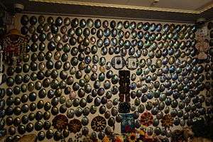
The town previously included the Paua House, created by Fred and Myrtle Flutey. This was an ordinary bungalow transformed by having the outside walls totally covered in paua shells. The interior was also extensively decorated with paua and there is an extensive collection of (often kitsch) paua-decorated ornaments, utensils and trinkets.
The house became a museum after the death of the owners, but was sold and in March 2007 the exhibits removed to Christchurch. It has been on permanent display at the Canterbury Museum since July 2008.[12]
The Bluff Maritime Museum contains an extensive collection of models, boats, artefacts, displays, a working triple expansion engine and a full sized oystering boat, the Monica.

Notable people
- Thomas Francis Doyle (1893–1968) member of the New Zealand Legislative Council
- Eric Roy (born 1948), member of the House of Representatives
- Sir Joseph George Ward (1856-1930), Mayor of Campbelltown, Chair Bluff Harbour Board, founder J.G.Ward and Co, MP for Awarua 1887-1919 and for Invercargill 1925-1930, Prime Minister of New Zealand 1906-1912 and 1928-30.
See also
References
- ↑ Population Estimates at 30 June 2006 Archived 16 October 2007 at the Wayback Machine. (from the Statistics New Zealand website)
- ↑ Bluff history – an overview Archived 14 October 2008 at the Wayback Machine. (from the 'bluff.co.nz' website. Accessed 14 December 2008.)
- ↑ BLUFF – Te Ara: The Encyclopedia of New Zealand. Teara.govt.nz. Retrieved on 2 August 2013.
- ↑ "A look at Bluff's past – part 2". Archived from the original on 3 June 2010.
- ↑ "South Port downplays prospect of bonanza". The New Zealand Herald. 28 September 2006. Retrieved 21 September 2011.
- ↑ "South Port counts on hub feeder network". The New Zealand Herald. 28 September 2007. Retrieved 21 September 2011.
- ↑ "South Port lifts profit forecast". The New Zealand Herald. 4 July 2008. Retrieved 21 September 2011.
- ↑ "Bluff keeps oyster festival after community rallies". The New Zealand Herald. 13 December 2007. Retrieved 21 September 2011.
- ↑ "Shellfish Fisheries" (PDF). Ministry of Fisheries. Retrieved 5 July 2008.
- ↑ "Te Kāhui Māngai directory". tkm.govt.nz. Te Puni Kōkiri.
- ↑ "Māori Maps". maorimaps.com. Te Potiki National Trust.
- ↑ "Paua shell house display at Canterbury Museum". Otago Daily Times. 5 July 2008. Retrieved 25 August 2015.
- Reed, A. W. (2002). The Reed Dictionary of New Zealand Place Names. Auckland: Reed Books. ISBN 0-7900-0761-4.
External links
| Wikimedia Commons has media related to Bluff, New Zealand. |
- Bluff (from Bluff Promotions)
- Bluff in the 1966 Encyclopaedia of New Zealand
- World History of Bluff