Geography of Vanuatu
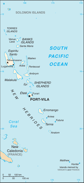
Vanuatu (formerly called the New Hebrides) is a nation and group of islands in the South Pacific Ocean. It is composed of over 80 islands with 2,528 kilometres (1,571 mi) of coastline and a total surface area of 12,189 square kilometres (4,706 sq mi).
Vanuatu's geographic coordinates are 16°00′S 167°00′E / 16.000°S 167.000°E. It is part of Oceania. Its immediate neighbours include the Solomon Islands and New Caledonia, and Australia is the closest continent.
Terrain
Vanuatu is a mountainous archipelago of volcanic origin with narrow coastal plains.
The highest of all the mountains is Mount Tabwemasana at 1,877 metres (6,158 ft). Its tropical climate is moderated by southeast trade winds, and its natural resources include, hardwood forests, and fish. As of 2011, 1.64% of its land area is arable, 10.25% is devoted to crops, and a further 88.11% to other land usage.
Natural disasters include tropical cyclones or typhoons from January to April and volcanic activity which sometimes causes minor earthquakes. Tsunamis are also a hazard.
A majority of the population does not have access to a potable and reliable supply of water. Deforestation is another major concern on the islands.
Vanuatu is party to a number of international agreements, including agreements on Antarctic-Marine Living Resources, Biodiversity, Climate Change, Climate Change-Kyoto Protocol, Desertification, Endangered Species, Law of the Sea, Marine Dumping, Ozone Layer Protection, Ship Pollution, and Tropical Timber 94.
Closely tied to the Law of the Sea, Vanuatu lays maritime claim to 24 nautical miles (nm) of contiguous zone, 12 nm of territorial sea, and 200 nm of continental shelf and exclusive economic zone.