Einavatnet
| Einavatnet | |
|---|---|
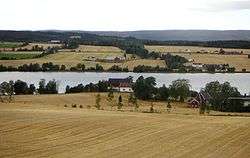 with the farmland along the lake | |
| Location | Vestre Toten, Oppland |
| Coordinates | 60°34′47″N 10°38′04″E / 60.57972°N 10.63444°E / 60.57972; 10.63444Coordinates: 60°34′47″N 10°38′04″E / 60.57972°N 10.63444°E / 60.57972; 10.63444 |
| Basin countries | Norway |
| Surface area | 13.52 km2 (5.22 sq mi) |
| Surface elevation | 398 m (1,306 ft) |
Einavatnet is a lake which lies in Vestre Toten municipality in Oppland county, Norway. It has an area of 13.52 square kilometres (5.22 sq mi) and is 39.54 kilometres (24.57 mi) around. It lies at an elevation of 398 metres (1,306 ft) above sea level.[1]
Name
The Norse form of the name was probably just *Eini. This name is derived from einir m 'juniper' (referring to the vegetation around the lake). The last element -vatnet (the finitt form of vatn n 'water, lake') is a later addition.
References
- ↑ "Einavatnet". Retrieved July 25, 2012.
This article is issued from
Wikipedia.
The text is licensed under Creative Commons - Attribution - Sharealike.
Additional terms may apply for the media files.