Eide, Møre og Romsdal
| Eide | |
|---|---|
| Village | |
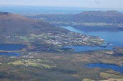 View of the village | |
 Eide Location in Møre og Romsdal  Eide Eide (Norway) | |
| Coordinates: 62°55′02″N 07°26′48″E / 62.91722°N 7.44667°ECoordinates: 62°55′02″N 07°26′48″E / 62.91722°N 7.44667°E | |
| Country | Norway |
| Region | Western Norway |
| County | Møre og Romsdal |
| District | Nordmøre |
| Municipality | Eide Municipality |
| Area[1] | |
| • Total | 1.58 km2 (0.61 sq mi) |
| Elevation[2] | 38 m (125 ft) |
| Population (2013)[1] | |
| • Total | 1,332 |
| • Density | 843/km2 (2,180/sq mi) |
| Time zone | UTC+01:00 (CET) |
| • Summer (DST) | UTC+02:00 (CEST) |
| Post Code | 6490 Eide |
Eide is the administrative centre of Eide Municipality in Møre og Romsdal county, Norway, where it sits on the Romsdal Peninsula at the intersection of the Kornstadfjorden and Kvernesfjorden.
The village is about 5 kilometres (3.1 mi) southeast of the small village of Visnes.
Eide Church, the main church for the municipality, is located in Eide. The 1.58-square-kilometre (390-acre) village has a population (2013) of 1,332; which gives the village a population density of 843 inhabitants per square kilometre (2,180/sq mi).[1]
References
- 1 2 3 Statistisk sentralbyrå (1 January 2013). "Urban settlements. Population and area, by municipality".
- ↑ "Eide" (in Norwegian). yr.no. Retrieved 2013-05-06.
This article is issued from
Wikipedia.
The text is licensed under Creative Commons - Attribution - Sharealike.
Additional terms may apply for the media files.