Clarks Fork Yellowstone River
| Clarks Fork Yellowstone River | |
| River | |
| Country | United States |
|---|---|
| State | Montana, Wyoming |
| Source | Beartooth Mountains |
| - location | 45°02′33″N 109°53′42″W / 45.04250°N 109.89500°W[1] |
| Mouth | Laurel, Montana |
| - elevation | 3,241 ft (988 m) |
| - coordinates | 45°39′00″N 108°42′55″W / 45.65000°N 108.71528°WCoordinates: 45°39′00″N 108°42′55″W / 45.65000°N 108.71528°W |
| Length | 141 mi (227 km) |
 | |
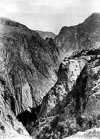
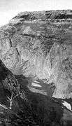
| Type | Wild |
| Designated | November 28, 1990 |
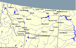
The Clarks Fork of the Yellowstone River (sometimes called the Clark's Fork River) is a tributary of the Yellowstone River, 150 mi (241 km) long in the U.S. states of Montana and Wyoming.[2]
It rises in southern Montana, in the Gallatin National Forest in the Beartooth Mountains, approximately 4 mi (6 km) northeast of Cooke City and southwest of Granite Peak. It flows southeast into the Shoshone National Forest in northwest Wyoming, east of Yellowstone National Park, then northeast back into Montana. It passes Belfry, Bridger, Fromberg, and Edgar, and joins the Yellowstone approximately 2 mi (3 km) southeast of Laurel.
The Clarks Fork of the Yellowstone River should not be confused with the Clark Fork River, which is located in Montana and Idaho.
See also
References
- ↑ "Clarks Fork of the Yellowstone". Geographic Names Information System. United States Geological Survey.
- ↑ George William Sherk (2000), Dividing the Waters: The Resolution of Interstate Water Conflicts in the United States, Martinus Nijhoff Publishers, ISBN 978-90-411-9819-8