Calverton, Maryland
| Calverton, Maryland | |
|---|---|
| Census-designated place | |
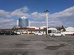 The Villa and Calverton Tower in March 2018 | |
 Location of Calverton, Maryland | |
| Coordinates: 39°3′25″N 76°56′41″W / 39.05694°N 76.94472°WCoordinates: 39°3′25″N 76°56′41″W / 39.05694°N 76.94472°W | |
| Country |
|
| State |
|
| Counties |
|
| Area | |
| • Total | 4.6 sq mi (12.0 km2) |
| • Land | 4.6 sq mi (11.9 km2) |
| • Water | 0.02 sq mi (0.05 km2) |
| Elevation | 276 ft (84 m) |
| Population (2010) | |
| • Total | 17,724 |
| • Density | 3,800/sq mi (1,500/km2) |
| Time zone | UTC−5 (Eastern (EST)) |
| • Summer (DST) | UTC−4 (EDT) |
| FIPS code | 24-12350 |
| GNIS feature ID | 0597167 |
Calverton is an unincorporated area and census-designated place located on the boundary between Montgomery and Prince George's counties, Maryland, in the United States.[1] At the 2010 census, it had a population of 17,724.[2]
Geography
As an unincorporated area, Calverton's boundaries are not officially defined. Calverton is, however, recognized by the United States Census Bureau as a census-designated place, and by the United States Geological Survey as a populated place located at 39°3′25″N 76°56′41″W / 39.05694°N 76.94472°W (39.057009, −76.944805)[3] and is part of the Baltimore/Washington area.
According to the United States Census Bureau, Calverton has a total area of 4.6 square miles (12.0 km2), of which 0.02 square miles (0.05 km2), or 0.44%, is water.[4]
Demographics
At the 2000 census,[5] there were 12,610 people, 4,543 households and 3,230 families residing in the area. The population density was 2,673.1 per square mile (1,031.5/km²). There were 4,661 housing units at an average density of 988.1/sq mi (381.3/km²). The racial makeup of the area was 43.09% White, 34.06% African American, 0.14% Native American, 16.52% Asian, 0.01% Pacific Islander, 2.61% from other races, and 3.57% from two or more races. Hispanic or Latino of any race were 6.37% of the population.
There were 4,543 households of which 35.7% had children under the age of 18 living with them, 54.4% were married couples living together, 13.0% had a female householder with no husband present, and 28.9% were non-families. 23.5% of all households were made up of individuals and 4.0% had someone living alone who was 65 years of age or older. The average household size was 2.73 and the average family size was 3.24.
25.0% of the population were under the age of 18, 7.6% from 18 to 24, 33.0% from 25 to 44, 24.0% from 45 to 64, and 10.4% who were 65 years of age or older. The median age was 36 years. For every 100 females, there were 91.4 males. For every 100 females age 18 and over, there were 86.0 males.
The median household income was $63,990 and the median family income was $72,958. Males had a median income of $44,425 and females $39,563. The per capita income was $28,107. About 2.5% of families and 4.0% of the population were below the poverty line, including 2.7% of those under age 18 and 2.5% of those age 65 or over.
Government and infrastructure
Prince George's County Police Department District 6 Station in Beltsville CDP serves the portion of Calverton in PG County.[6]
The U.S. Postal Service operates the Colesville Carrier Annex in the Montgomery County side of Calverton CDP.[7][8]
Education
Primary and secondary schools
Public schools
Children living on the Montgomery County side of Calverton attend public schools in the Montgomery County Public Schools system.[7] They generally attend:
- Galway Elementary School on Galway Drive in Calverton CDP.[9]
- Briggs Chaney Middle School on Rainbow Drive in Cloverly CDP
- Paint Branch High School on Old Columbia Pike in Fairland CDP
Children living on the Prince George's County side of Calverton attend public schools in the Prince George's County Public Schools system.[7] They generally attend:
- Calverton Elementary School on Beltsville Road in Calverton CDP[10]
- Martin Luther King Middle School on Amendale Road in Beltsville CDP.[11]
- High Point High School on Powder Mill Road in Beltsville CDP.[12]
In popular culture
Calverton is mentioned in the movie Timecop.
References
| Wikimedia Commons has media related to Calverton, Maryland. |
- ↑ U.S. Geological Survey Geographic Names Information System: Calverton, Maryland
- ↑ "Profile of General Population and Housing Characteristics: 2010 Demographic Profile Data (DP-1): Calverton CDP, Maryland". U.S. Census Bureau, American Factfinder. Archived from the original on September 11, 2013. Retrieved December 15, 2011.
- ↑ "US Gazetteer files: 2010, 2000, and 1990". United States Census Bureau. February 12, 2011. Retrieved April 23, 2011.
- ↑ "Geographic Identifiers: 2010 Demographic Profile Data (G001): Calverton CDP, Maryland". U.S. Census Bureau, American Factfinder. Archived from the original on September 11, 2013. Retrieved December 15, 2011.
- ↑ "American FactFinder". United States Census Bureau. Archived from the original on September 11, 2013. Retrieved January 31, 2008.
- ↑ "District 6 Station - Beltsville." Prince George's County Police Department. Retrieved on September 9, 2018. "4321 Sellman Road Beltsville, MD 20704 ". Beat map. See 2010 U.S. Census index map of Beltsville CDP: area with police station is page 3.
- 1 2 3 "2010 CENSUS - CENSUS BLOCK MAP: Calverton CDP, MD." U.S. Census Bureau. Retrieved on January 31, 2018.
- ↑ "COLESVILLE CARRIER ANNEX." U.S. Census Bureau. Retrieved on September 11, 2018. "12010 PLUM ORCHARD DR SILVER SPRING, MD 20904-9996"
- ↑ Home. Galway Elementary School. Retrieved on January 31, 2018.
- ↑ "NEIGHBORHOOD ELEMENTARY SCHOOLS AND BOUNDARIES SCHOOL YEAR 2017-2018." Prince George's County Public Schools. Retrieved on January 31, 2018.
- ↑ "NEIGHBORHOOD MIDDLE SCHOOLS AND BOUNDARIES SCHOOL YEAR 2017-2018." Prince George's County Public Schools. Retrieved on January 31, 2018.
- ↑ "NEIGHBORHOOD HIGH SCHOOLS AND BOUNDARIES SCHOOL YEAR 2017-2018." Prince George's County Public Schools. Retrieved on January 31, 2018.
Municipalities and communities of Montgomery County, Maryland, United States | ||
|---|---|---|
| Cities | 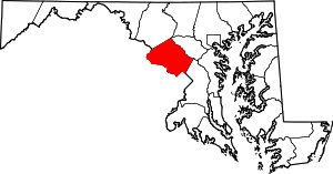 | |
| Towns | ||
| Villages & Special Tax Districts | ||
| CDPs |
| |
| Unincorporated communities | ||
| Footnotes | ‡This populated place also has portions in an adjacent county or counties | |
| Principal cities |
|   | ||||||
|---|---|---|---|---|---|---|---|---|
| Counties and county equivalents* |
| |||||||
The District of Columbia itself, and Virginia's incorporated cities, are county equivalents. Virginia's incorporated cities are listed under their surrounding county. The incorporated cities bordering more than one county (Alexandria, Falls Church and Fredericksburg) are listed under the county they were part of before incorporation as a city. | ||||||||