North Potomac, Maryland
| North Potomac, Maryland | |
|---|---|
| City | |
 | |
| Coordinates: 39°5′50″N 77°14′3″W / 39.09722°N 77.23417°WCoordinates: 39°5′50″N 77°14′3″W / 39.09722°N 77.23417°W | |
| Country |
|
| State |
|
| County |
|
| Area | |
| • Total | 6.5 sq mi (17.0 km2) |
| • Land | 6.5 sq mi (16.9 km2) |
| • Water | 0.0 sq mi (0.0 km2) |
| Elevation | 259 ft (79 m) |
| Population (2010) | |
| • Total | 24,410 |
| • Density | 3,522.1/sq mi (1,359.9/km2) |
| Time zone | UTC−5 (Eastern (EST)) |
| • Summer (DST) | UTC−4 (EDT) |
| ZIP code | 20878, 20850 |
| Area code(s) | 301 and 240 |
| FIPS code | 24-56875 |
| GNIS feature ID | 1713001 |
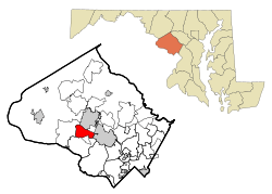
North Potomac is a census-designated place and an unincorporated area in Montgomery County, Maryland, United States.
Geography
North Potomac is located in west central Montgomery County, northeast of the Potomac River. It is conveniently located 3 miles from Gaithersburg and 20 miles from Washington, DC. The geographic location can be viewed at the Official North Potomac Map.
As an unincorporated area, North Potomac's boundaries are not officially defined. North Potomac is, however, recognized by the United States Census Bureau as a census-designated place, and by the United States Geological Survey as a populated place located at 39°5′50″N 77°14′3″W / 39.09722°N 77.23417°W (39.097206, −77.234213).[1]
According to the United States Census Bureau, the place has a total area of 6.6 square miles (17 km2), all of it land. The main artery for the area is Darnestown Road (Designated as MD 28 west of its intersection with Key West Avenue) which connects North Potomac with the other affluent communities nearby (Potomac and Bethesda) and provides access to Interstate 270 (Exit-6).
Demographics
| Historical population | |||
|---|---|---|---|
| Census | Pop. | %± | |
| 1970 | 12,546 | — | |
| 1990 | 18,456 | — | |
| 2000 | 23,044 | 24.9% | |
| 2010 | 24,410 | 5.9% | |
| source:[2][3] | |||
As of the census[4] of 2010, there were 24,410 people, 8,040 households, and 6,867 families residing in the area. The population density was 3,522.1 people per square mile (1,360.4/km²). There were 7,002 housing units at an average density of 1,070.2/sq mi (413.4/km²). The racial makeup of the area was 56.8% White (53.3% non-Hispanic white), 5.5% African American, 0.2% Native American, 33.9% Asian (18.4% Chinese, 7.4% Indian, 4.7% Korean, 0.7% Vietnamese, 0.5% Filipino, 0.3% Japanese, 1.9% "Other"), 0.0% Pacific Islander, and 2.9% from two or more races. Hispanic or Latino of any race were 4.8% of the population.
There were 6,924 households out of which 60.0% had children under the age of 18 living with them, 79.9% were married couples living together, 7.9% had a female householder with no husband present, and 9.8% were non-families. 7.6% of all households were made up of individuals and 1.0% had someone living alone who was 65 years of age or older. The average household size was 3.33 and the average family size was 3.51.
In the area, the population was spread out with 34.2% under the age of 18, 5.7% from 18 to 24, 29.2% from 25 to 44, 27.2% from 45 to 64, and 3.7% who were 65 years of age or older. The median age was 36 years. For every 100 females, there were 97.8 males. For every 100 females age 18 and over, there were 93.7 males.
According to a 2007 estimate,[5] the median income for a household in the area was $156,275, and the median income for a family was $164,522. Males had a median income of $91,216 versus $79,634 for females. The per capita income for the area was $57,573. About 0.9% of families and 1.1% of the population were below the poverty line, including 1.6% of those under age 18 and 2.4% of those age 65 or over.
According to the U.S. Census conducted in 2000, 14.5% of North Potomac's residents identified themselves as being of Chinese ancestry, which was the highest in any place besides California and Hawaii.[6]
References
- ↑ "US Gazetteer files: 2010, 2000, and 1990". United States Census Bureau. 2011-02-12. Retrieved 2011-04-23.
- ↑ "CENSUS OF POPULATION AND HOUSING (1790-2000)". United States Census Bureau. Retrieved 2010-07-17.
- ↑ Census area not enumerated separately in 1980.
- ↑ "American FactFinder". United States Census Bureau. Retrieved 2008-01-31.
- ↑ "North Bethesda CDP, Maryland, 2005-2009 American Community Survey 5-Year Estimates". United States Census Bureau.
- ↑ Chinese Communities, Epodunk. Accessed January 22, 2009.
External links
- North Potomac Citizens Association
- North Potomac Community Center
- North Potomac - Facebook
- Potomac Horse Center (in North Potomac)
Municipalities and communities of Montgomery County, Maryland, United States | ||
|---|---|---|
| Cities | 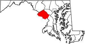 | |
| Towns | ||
| Villages & Special Tax Districts | ||
| CDPs |
| |
| Unincorporated communities | ||
| Footnotes | ‡This populated place also has portions in an adjacent county or counties | |