Springdale, Maryland
| Springdale, Maryland | |
|---|---|
| Census-designated place | |
 | |
| Coordinates: 38°56′14″N 76°50′45″W / 38.93722°N 76.84583°WCoordinates: 38°56′14″N 76°50′45″W / 38.93722°N 76.84583°W | |
| Country |
|
| State |
|
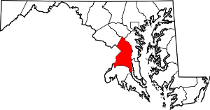
| County |
|
| Area | |
| • Total | 0.8 sq mi (2.1 km2) |
| • Land | 0.8 sq mi (2.1 km2) |
| • Water | 0.0 sq mi (0.0 km2) |
| Elevation | 115 ft (35 m) |
| Population (2010) | |
| • Total | 2,994 |
| • Density | 3,700/sq mi (1,400/km2) |
| Time zone | UTC−5 (Eastern (EST)) |
| • Summer (DST) | UTC−4 (EDT) |
| ZIP code | 20774 |
| Area code(s) | 301 |
| FIPS code | 24-74282 |
| GNIS feature ID | 1852601 |
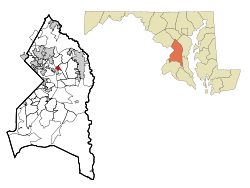
Springdale is an unincorporated area and census-designated place (CDP) in Prince George's County, Maryland, United States.[1] The population was 2,994 at the 2010 census.[2]
Geography
Springdale is located at 38°56′14″N 76°50′45″W / 38.93722°N 76.84583°W (38.937244, −76.845734).[3]
According to the United States Census Bureau, the CDP has a total area of 0.8 square miles (2.1 km2), all of it land.
Demographics
As of the census[4] of 2000, there were 2,645 people, 836 households, and 699 families residing in the CDP. The population density was 3,215.6 people per square mile (1,245.4/km²). There were 862 housing units at an average density of 1,047.9/sq mi (405.9/km²). The racial makeup of the CDP was 2.72% White, 92.29% African American, 0.26% Native American, 1.74% Asian, 0.08% Pacific Islander, 0.83% from other races, and 2.08% from two or more races. Hispanic or Latino of any race were 1.59% of the population.
There were 836 households out of which 44.4% had children under the age of 18 living with them, 63.5% were married couples living together, 15.7% had a female householder with no husband present, and 16.3% were non-families. 12.4% of all households were made up of individuals and 2.5% had someone living alone who was 65 years of age or older. The average household size was 3.16 and the average family size was 3.40.
In the CDP, the population was spread out with 30.9% under the age of 18, 6.4% from 18 to 24, 32.6% from 25 to 44, 24.4% from 45 to 64, and 5.7% who were 65 years of age or older. The median age was 35 years. For every 100 females, there were 94.1 males. For every 100 females age 18 and over, there were 87.9 males.
The median income for a household in the CDP was $82,341, and the median income for a family was $81,811. Males had a median income of $45,731 versus $42,326 for females. The per capita income for the CDP was $28,119. About 1.4% of families and 3.0% of the population were below the poverty line, including 5.6% of those under age 18 and none of those age 65 or over.
Government
Prince George's County Police Department District 2 Station in Brock Hall CDP, with a Bowie postal address, serves the community.[5]
Education
Springdale is within the Prince George's County Public Schools.[6] Zoned schools are Ardmore Elementary School,[7] Ernest Everett Just Middle School,[8] and Charles H. Flowers High School.[9]
References
- ↑ U.S. Geological Survey Geographic Names Information System: Springdale, Maryland
- ↑ "Profile of General Population and Housing Characteristics: 2010 Demographic Profile Data (DP-1): Springdale CDP, Maryland". U.S. Census Bureau, American Factfinder. Retrieved December 23, 2011.
- ↑ "US Gazetteer files: 2010, 2000, and 1990". United States Census Bureau. 2011-02-12. Retrieved 2011-04-23.
- ↑ "American FactFinder". United States Census Bureau. Retrieved 2008-01-31.
- ↑ "District 2 Station - Bowie." Prince George's County Police Department. Retrieved on September 9, 2018. "District 2 Station - Bowie 601 SW Crain Highway Bowie, MD 20715 ". Beat map. 2010 U.S. Census Bureau index map of Brock Hall CDP as well as the detail on Page 1.
- ↑ "2010 CENSUS - CENSUS BLOCK MAP: Springdale CDP, MD." U.S. Census Bureau. Retrieved on September 1, 2018.
- ↑ "NEIGHBORHOOD ELEMENTARY SCHOOLS AND BOUNDARIES SCHOOL YEAR 2018-2019." Prince George's County Public Schools. Retrieved on September 1, 2018.
- ↑ "NEIGHBORHOOD MIDDLE SCHOOLS AND BOUNDARIES SCHOOL YEAR 2018-2019." Prince George's County Public Schools. Retrieved on September 1, 2018.
- ↑ "NEIGHBORHOOD HIGH SCHOOLS AND BOUNDARIES SCHOOL YEAR 2018-2019." Prince George's County Public Schools. Retrieved on September 1, 2018.