Recto Avenue
| |
|---|---|
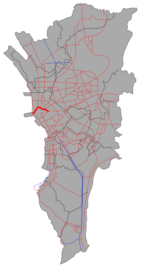 The route of Recto Avenue in Metro Manila. Recto Avenue is highlighted in red. | |
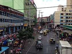 Recto Avenue looking west towards Divisoria from Abad Santos Avenue overpass | |
| Route information | |
| Length | 3.2 km (2.0 mi) |
| Component highways |
|
| Major junctions | |
| West end | Marcos Road in Tondo |
|
Juan Luna Street Abad Santos Avenue Rizal Avenue Quezon Boulevard | |
| East end | Legarda Street in San Miguel |
| Location | |
| Districts | Binondo, Quiapo, Sampaloc, San Miguel, San Nicolas, Santa Cruz, Tondo |
| Highway system | |
|
Roads in the Philippines | |
.svg.png)

Claro M. Recto Avenue, more popularly known as simply Recto Avenue, is the principal commercial thoroughfare in north central Manila, Philippines. It spans seven districts just north of the Pasig River in what is generally considered Manila's old downtown area.
Recto's western terminus is at an intersection with Marcos Road (Radial Road 10) in Tondo close to the Manila North Harbor and San Nicolas district. It runs northeast before curving to the east at Juan Luna Street and Estero de Binondo. It then passes through the Divisoria shopping area of Manila south of the Tutuban railway station until it curves southeast past the Antonio Rivera Street junction. East of Rizal Avenue and Santa Cruz district, Recto intersects with the streets of the University Belt area of Quiapo and Sampaloc before terminating at Legarda Street and Mendiola Bridge in San Miguel.
The Manila Light Rail Transit System Line 2 runs along its Rizal Avenue–Legarda Street segment. It has a short extension into San Miguel and the gated Malacañan Palace compound as Mendiola Street.
History
Recto Avenue was developed by sections in various time periods during the course of Spanish rule. The main section leading to the coast in San Nicolas and Tondo from Binondo was named Paseo de Azcárraga, after the Spanish Prime Minister, Marcelo Azcárraga Palmero.
In the Santa Cruz district, the road was divided into Calle General Izquierdo, Calle Paz and Calle Bilibid because of the three creeks (esteros) that ran through the district. In Sampaloc, the road was named Calle Iris which terminated at Calle Alix (now Legarda Street).[1] The name Paseo de Azcárraga was extended to include the full length of the street which was also called Paseo de Felipe at one point (after King Philip II of Spain). Finally, in 1961, the avenue was given its present name in honour of the Filipino senator, Claro Mayo Recto.[2]
On July 7, 1892, in a building numbered 72 Calle Azcárraga, at the intersection with Calle Sagunto (now Santo Cristo) in Tondo, Andres Bonifacio founded the revolutionary society named Katipunan.[3]
In the early 1900s, the avenue was a theater-and-restaurant row, with Teatro Libertad and Zorilla Theater attracting the well-dressed crowd to zarzuela shows and operas that ran on weekends.[4]
Transportation
Recto Avenue is a major stop on three lines of the Metro Manila Transit System.
- Doroteo Jose Station at Rizal Avenue served by LRT-1.
- Recto Station at Rizal Avenue served by LRT-2.
- Tutuban railway station at Dagupan Street served by PNR.
The route is also served by several bus companies and jeepneys.
Landmarks
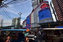
_(2014).JPG)
- Shopping malls
- 168 Shopping Mall
- 999 Shopping Mall
- D8 Mall (formerly Benisons Shopping Center)
- Ever Gotesco Manila Plaza
- Isetann Cinerama Recto
- Lucky Chinatown
- Odeon Terminal Mall
- Tutuban Center
- Universities and colleges
- Other notable buildings
- Basilica of San Sebastian, Manila
- Bilibid Viejo (Manila City Jail)
- Manila Grand Opera Hotel
- Tutuban railway station
See also
References
- ↑ Did you know? Recto Avenue published by the Philippine Daily Inquirer; accessed 2013-10-15.
- ↑ Old Manila streets lose names to politicians Archived 2010-07-17 at the Wayback Machine. published by the Philippine Daily Inquirer; accessed 2013-10-15.
- ↑ "The Philippines, the land of palm and pine : an official guide and hand book (1912)". Manila Bureau of Print. Retrieved 11 July 2014.
- ↑ The Americanization of Manila, 1898-1921. University of the Philippines Press. Retrieved 11 July 2014.
| Wikimedia Commons has media related to C.M. Recto Avenue. |
Coordinates: 14°36′17″N 120°58′39″E / 14.60472°N 120.97750°E