Bay Parkway (BMT West End Line)
Bay Parkway | |||||||
|---|---|---|---|---|---|---|---|
|
| |||||||
 | |||||||
| Station statistics | |||||||
| Address |
Bay Parkway & 86th Street Brooklyn, NY 11214 | ||||||
| Borough | Brooklyn | ||||||
| Locale | Bensonhurst, Bath Beach | ||||||
| Coordinates | 40°36′10″N 73°59′39″W / 40.602655°N 73.994293°WCoordinates: 40°36′10″N 73°59′39″W / 40.602655°N 73.994293°W | ||||||
| Division | B (BMT) | ||||||
| Line | BMT West End Line | ||||||
| Services |
D | ||||||
| Transit connections |
| ||||||
| Structure | Elevated | ||||||
| Platforms |
2 island platforms cross-platform interchange | ||||||
| Tracks | 3 (2 in regular service) | ||||||
| Other information | |||||||
| Opened | December 29, 1916 | ||||||
| Station code | 068[1] | ||||||
| Accessible |
| ||||||
| Former/other names | Bay Parkway–22nd Avenue | ||||||
| Traffic | |||||||
| Passengers (2017) |
2,502,105[2] | ||||||
| Rank | 201 out of 425 | ||||||
| Station succession | |||||||
| Next north |
62nd Street (express): no regular service 20th Avenue (local): D | ||||||
| Next south |
25th Avenue (local): D Coney Island–Stillwell Avenue (express): no regular service | ||||||
|
| |||||||
| Next |
Atlantic Avenue–Barclays Center: D | ||||||
| Next |
Coney Island–Stillwell Avenue: D | ||||||
| |||||||
| |||||||
| |||||||
|
| |||||||
|
Bay Parkway Station (Dual System BRT) | |||||||
| MPS | New York City Subway System MPS | ||||||
| NRHP reference # | 05000670[3] | ||||||
| Added to NRHP | July 6, 2005 | ||||||


Bay Parkway (formerly Bay Parkway–22nd Avenue) is an express station on the BMT West End Line of the New York City Subway, located in Bensonhurst, Brooklyn at the intersection of Bay Parkway and 86th Street. The station is served by the D train at all times.
Station layout
| P Platform level |
Northbound local | ← |
| Island platform, doors will open on the left | ||
| Peak-direction express | → No regular service (No service: 62nd Street (north) or Coney Island–Stillwell Avenue (south)) | |
| Island platform, doors will open on the left | ||
| Southbound local | → | |
| M | Mezzanine | to entrances/exits, station agent, MetroCard vending machines |
| G | Street Level | Entrances/Exits |
This elevated station, opened on December 29, 1916, has two island platforms and three tracks. The center track is not normally used in revenue service. Both platforms have brown canopies with green frames and support columns in their center as well as wooden benches surrounded by green windscreens. On either sides, there are windscreen-style station signs and round lampposts. There is a signal tower at the south end of the station, at the end of the northbound platform.
This station was the terminus for the M train from 1987 to 2010 during rush hours. Although both platforms had signs indicating M trains used the center express track, they actually operated from the local tracks because there are no switches north of the station to allow trains to switch to the express track.[4] South of the platforms, two diamond crossovers were used for M trains to relay or be stored on the center track before switching to the Manhattan-bound local one for the trip northbound.
A concrete structure was built over the steel at this station. On July 6, 2005, it was listed on the National Register of Historic Places.
In 2012, the station was rehabilitated and three passenger elevators (one from each platform to the mezzanine, and one from the mezzanine to street level) were added with funding from the American Recovery and Reinvestment Act of 2009.[5]
Exits
This station has one metal station house with concrete floors below the platforms and tracks. Two staircases from each platform go down to a waiting area/crossover, where a turnstile bank provides access to and from the station. Outside fare control, there is a token booth and four staircases going down to all corners of Bay Parkway and 86th Street. The station house formerly had windows on all four sides. However, all of them except the ones on the west side have been covered with tar.[6]
Gallery
 Elevated station house and structure
_-_SE_street_stair.JPG) Southeastern street stair
Southeastern street stair Street stair before M train service to the station was discontinued
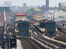 The station as seen from the 20th Avenue station down the line
 One of three new elevators
References
- ↑ "Station Developers' Information". Metropolitan Transportation Authority. Retrieved June 13, 2017.
- ↑ "Facts and Figures: Annual Subway Ridership 2012–2017". Metropolitan Transportation Authority. July 12, 2018. Retrieved July 12, 2018.
- ↑ "NPS Focus". National Register of Historic Places. National Park Service. Retrieved December 12, 2011.
- ↑ Marrero, Robert (January 1, 2017). "472 Stations, 850 Miles" (PDF). B24 Blog, via Dropbox. Retrieved April 27, 2018.
- ↑ "MTA completes seven station rehabilitation projects along D Line". Railway Track & Structures. August 3, 2012. Retrieved August 6, 2012.
- ↑ "MTA Neighborhood Maps: Coney Island" (PDF). mta.info. Metropolitan Transportation Authority. 2015. Retrieved August 15, 2016.
External links
| Wikimedia Commons has media related to Bay Parkway (BMT West End Line). |
- nycsubway.org – BMT West End Line: Bay Parkway
- Station Reporter — D Train
- Bay Parkway entrance from Google Maps Street View
- Platforms from Google Maps Street View
| West End Line | |
|---|---|
| |
| Topics |   | |
|---|---|---|
| Lists by county |
| |
| Lists by city | ||
| Other lists | ||
| ||