170th Street (IND Concourse Line)
170 Street | |||||||||
|---|---|---|---|---|---|---|---|---|---|
|
| |||||||||
 Southbound station platform | |||||||||
| Station statistics | |||||||||
| Address |
East 170th Street & Grand Concourse Bronx, NY 10452 | ||||||||
| Borough | The Bronx | ||||||||
| Locale | Highbridge | ||||||||
| Coordinates | 40°50′20″N 73°54′49″W / 40.838814°N 73.913741°WCoordinates: 40°50′20″N 73°54′49″W / 40.838814°N 73.913741°W | ||||||||
| Division | B (IND) | ||||||||
| Line | IND Concourse Line | ||||||||
| Services |
B D | ||||||||
| Transit connections |
| ||||||||
| Structure | Underground | ||||||||
| Platforms | 2 side platforms | ||||||||
| Tracks | 3 | ||||||||
| Other information | |||||||||
| Opened | July 1, 1933 | ||||||||
| Station code | 217[1] | ||||||||
| Wireless service |
| ||||||||
| Traffic | |||||||||
| Passengers (2017) |
2,270,027[3] | ||||||||
| Rank | 217 out of 425 | ||||||||
| Station succession | |||||||||
| Next north |
174th–175th Streets: temporarily closed for construction Tremont Avenue: B | ||||||||
| Next south |
167th Street: temporarily closed for construction 161st Street–Yankee Stadium: B | ||||||||
| |||||||||
| |||||||||
| |||||||||


170th Street is a local station on the IND Concourse Line of the New York City Subway, located at the Grand Concourse between East 170th and 171st Streets in the Highbridge section of the Bronx. It is served by the D train at all times except rush hours in the peak direction and the B train during rush hours.
Station layout
| G | Street level | Exit/entrance |
| M | Mezzanine | Fare control, station agent, MetroCard machines |
| P Platform level |
Side platform, doors will open on the right | |
| Northbound local | ← ← (Temporarily closed for construction: 174th–175th Streets) | |
| Peak-direction express | ← | |
| Southbound local | (Temporarily closed for construction: 167th Street) | |
| Side platform, doors will open on the right | ||
This underground station, opened on July 1, 1933, has three tracks and two side platforms. The center express track is used by the D train during rush hours in the peak direction.
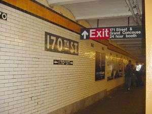
Both platforms have an orange trim line on a black border and name tablets reading "170TH ST." in white sans serif lettering on a gray background. Small "170" and directional signs with white numbering on a black background run below the trim line and name tablets. Yellow i-beam columns run along both platforms and the full-time mezzanine with alternating ones having the standard black station name plate with white lettering.
South of this station, a fourth track to the west of the line begins at a bumper block. It merges with the southbound local track just before approaching 167th Street and is used for train storage.
Exits
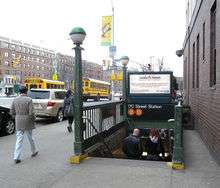
The full-time mezzanine is at the north end of the station. Two staircases from each platform go up to a waiting area/crossover, where a turnstile bank provides access to and from the station. Outside fare control, there is a token booth and two staircases going up to either northern corners of East 171st Street and Grand Concourse.[4]
Each platform has a same-level un-staffed fare control area at their south ends. On the Manhattan-bound side, a set of regular and High Entry/Exit Turnstiles lead to a mezzanine area, where two staircases go up to either western corners of East 170th Street and Grand Concourse. The fare control area on the Norwood-bound side is exit only, containing two high turnstiles and one staircase going up to the southeast corner of East 170th Street and Grand Concourse. Gated off staircases on both platforms adjacent to the un-staffed fare control areas go down to the East 170th Street tunnel below the Grand Concourse.[4]
References
- ↑ "Station Developers' Information". Metropolitan Transportation Authority. Retrieved June 13, 2017.
- ↑ "NYC Subway Wireless – Active Stations". Transit Wireless Wifi. Retrieved May 18, 2016.
- ↑ "Facts and Figures: Annual Subway Ridership 2012–2017". Metropolitan Transportation Authority. July 12, 2018. Retrieved July 12, 2018.
- 1 2 "MTA Neighborhood Maps: University Heights" (PDF). Metropolitan Transportation Authority. 2015. Retrieved October 7, 2015.
External links
- nycsubway.org – IND Concourse: 170th Street
- Station Reporter — B Train
- Station Reporter — D Train
- The Subway Nut — 170th Street Pictures
- 170th Street entrance from Google Maps Street View
- 171st Street entrance from Google Maps Street View
- Platforms from Google Maps Street View
| Concourse Line | |
|---|---|
| |