155th Street (IND Concourse Line)
155 Street | |||||||||
|---|---|---|---|---|---|---|---|---|---|
|
| |||||||||
 Northbound platform | |||||||||
| Station statistics | |||||||||
| Address |
West 155th Street (lower level) & Frederick Douglass Boulevard New York, NY 10032 & 10039 | ||||||||
| Borough | Manhattan | ||||||||
| Locale | Harlem, and the Coogan's Bluff section of Washington Heights | ||||||||
| Coordinates | 40°49′48″N 73°56′21″W / 40.829917°N 73.939104°WCoordinates: 40°49′48″N 73°56′21″W / 40.829917°N 73.939104°W | ||||||||
| Division | B (IND) | ||||||||
| Line | IND Concourse Line | ||||||||
| Services |
B D | ||||||||
| Transit connections |
| ||||||||
| Structure | Underground | ||||||||
| Platforms | 2 side platforms | ||||||||
| Tracks | 3 | ||||||||
| Other information | |||||||||
| Opened | July 1, 1933 | ||||||||
| Station code | 220[1] | ||||||||
| Wireless service |
| ||||||||
| Former/other names | 155th Street–Eighth Avenue | ||||||||
| Traffic | |||||||||
| Passengers (2017) |
1,212,240[3] | ||||||||
| Rank | 330 out of 425 | ||||||||
| Station succession | |||||||||
| Next north |
161st Street–Yankee Stadium: B | ||||||||
| Next south |
145th Street: B | ||||||||
| |||||||||
| |||||||||
| |||||||||


155th Street (155th Street–Eighth Avenue on some signage) is a local station on the IND Concourse Line of the New York City Subway. It is located at the intersection of the bi-level 155th Street's lower level and Frederick Douglass Boulevard, at the border of Harlem and the Coogan's Bluff section of Washington Heights neighborhoods of Manhattan. It is served by the D train at all times except rush hours in the peak direction and the B during rush hours only.
Station layout
| G | Street level | Exit/entrance |
| M | Mezzanine | Fare control, station agent, MetroCard machines |
| P Platform level |
Side platform, doors will open on the right | |
| Southbound local | ← ← | |
| Peak-direction express | ← | |
| Northbound local | | |
| Side platform, doors will open on the right | ||

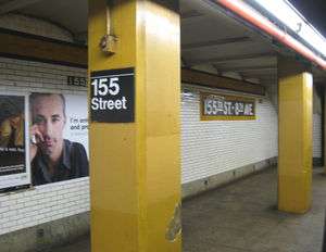
This underground station, opened on July 1, 1933, has two side platforms and three tracks. The center track is used by the D express train during rush hours in peak direction. Both platforms have an orange trim line with a black border and "155" in small white lettering on a black border underneath. The name tablets have "155TH ST. – 8TH AVE." in white sans serif lettering on a black background and green border. Yellow I-beam columns run along both platforms at regular intervals with alternating ones having the standard black name plate in white lettering.
The street staircase is extra wide since the Polo Grounds stadium, home of the former New York Giants, was directly upstairs before the team left for San Francisco in 1958. The stadium was demolished in 1964 to make way for public housing, after the New York Mets played there in 1962 and 1963. Today, Rucker Park is located at the entrance of the station.
An abandoned tower sits on the south end of the Brooklyn-bound platform. When the IRT Ninth Avenue Line and later Polo Grounds Shuttle was in service, there was a provision for transfer tickets between the IND underground level and the IRT elevated shuttle level. A very steep walk was needed to make this transfer.
This is the only station in Manhattan that is served solely by the IND Concourse Line. To the north, the line goes under the Harlem River towards 161st Street–Yankee Stadium in the Bronx. To the south, the line continues under Saint Nicholas Place to a transfer station with the IND Eighth Avenue Line at 145th Street. South of 145th Street, the IND Concourse Line merges with the IND Eighth Avenue Line.
Exit
This station has a full length mezzanine above the platforms. However, only the northern end is open and has six staircases to the platforms. The Brooklyn-bound one has four closed staircases while the Bronx-bound one has five. The mezzanine has yellow I-beam columns. The fare control area at the north end has a turnstile bank, token booth, one exit-only turnstile on each side of the mezzanine, and a quadruple-wide staircase diagonal to the mezzanine that goes up to the west side of Frederick Douglass Boulevard between 155th Street and Harlem River Drive.[4]
References
- ↑ "Station Developers' Information". Metropolitan Transportation Authority. Retrieved June 13, 2017.
- ↑ "NYC Subway Wireless – Active Stations". Transit Wireless Wifi. Retrieved May 18, 2016.
- ↑ "Facts and Figures: Annual Subway Ridership 2012–2017". Metropolitan Transportation Authority. July 12, 2018. Retrieved July 12, 2018.
- ↑ "MTA Neighborhood Maps: Riverdale" (PDF). mta.info. Metropolitan Transportation Authority. 2015. Retrieved September 15, 2015.
External links
| Wikimedia Commons has media related to 155th Street (IND Concourse Line). |
- nycsubway.org – IND Concourse: 155th Street/8th Avenue
- Station Reporter — B Train
- Station Reporter — D Train
- The Subway Nut — 155th Street – 8th Avenue Pictures
- Eighth Avenue entrance from Google Maps Street View
- Platforms from Google Maps Street View
| Concourse Line | |
|---|---|
| |