71st Street (BMT West End Line)
71 Street | |||||||
|---|---|---|---|---|---|---|---|
|
| |||||||
 | |||||||
| Station statistics | |||||||
| Address |
71st Street & New Utrecht Avenue Brooklyn, NY 11228 | ||||||
| Borough | Brooklyn | ||||||
| Locale | Bensonhurst | ||||||
| Coordinates | 40°37′09″N 73°59′56″W / 40.619165°N 73.998992°WCoordinates: 40°37′09″N 73°59′56″W / 40.619165°N 73.998992°W | ||||||
| Division | B (BMT) | ||||||
| Line | BMT West End Line | ||||||
| Services |
D | ||||||
| Structure | Elevated | ||||||
| Platforms | 2 side platforms | ||||||
| Tracks | 3 (2 in regular service) | ||||||
| Other information | |||||||
| Opened | September 15, 1916 | ||||||
| Station code | 064[1] | ||||||
| Traffic | |||||||
| Passengers (2017) |
1,854,361[2] | ||||||
| Rank | 260 out of 425 | ||||||
| Station succession | |||||||
| Next north |
62nd Street: D | ||||||
| Next south |
79th Street: D | ||||||
| |||||||
| |||||||
| |||||||


71st Street is a local station on the BMT West End Line of the New York City Subway, located at the intersection of 71st Street and New Utrecht Avenue in Bensonhurst, Brooklyn. It is served by the D train at all times.
Station layout
| P Platform level |
Side platform, doors will open on the right | |
| Northbound local | ← | |
| Peak-direction express | No regular service | |
| Southbound local | | |
| Side platform, doors will open on the right | ||
| M | Mezzanine | To entrances/exits, station agent, MetroCard vending machines |
| G | Street level | Entrance/exit |
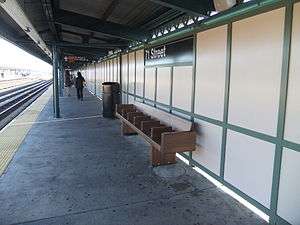
This elevated station, opened on September 15, 1916, has three tracks and two side platforms. The center express track is not normally used. Both platforms have beige windscreens and brown canopies with green frames and support columns along their entire lengths except for small sections at either ends. Here, they have waist-high black steel fences with lampposts at regular intervals. The station signs are in the standard black plates with white lettering. The platforms were extended to the south in the 1950s to accommodate the current standard "B" Division train length of 600 feet.
In 2012, the station was rehabilitated with funding from the American Recovery and Reinvestment Act of 2009.[3]
Exits
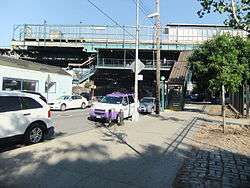
The station has two fare control areas, both of which are elevated station houses beneath the platforms and tracks. The full-time one is at the south end. A single staircase from each platform go down to a waiting area/crossunder, where a turnstile bank provides access to/from the system. Outside fare control, there is a token booth and four staircases going down to all corners of New Utrecht Avenue and 71st Street. The two southern staircases face south while the two northern ones face east or west.[4]
The station's other fare control area towards the north end is un-staffed. A single staircase from each platform goes down to a landing around a now-closed station house. A single full height turnstile provides access to/from the station before another staircase goes down to either southern corners of New Utrecht Avenue and 69th Street. Nearby is the Lieutenant Joseph Petrosino Park.[4]
References
- ↑ "Station Developers' Information". Metropolitan Transportation Authority. Retrieved June 13, 2017.
- ↑ "Facts and Figures: Annual Subway Ridership 2012–2017". Metropolitan Transportation Authority. July 12, 2018. Retrieved July 12, 2018.
- ↑ "MTA completes seven station rehabilitation projects along D Line". Railway Track & Structures. August 3, 2012. Retrieved August 6, 2012.
- 1 2 "MTA Neighborhood Maps: Bensonhurst" (PDF). mta.info. Metropolitan Transportation Authority. 2015. Retrieved August 15, 2016.
External links
- nycsubway.org – BMT West End Line: 71st Street
- Station Reporter — D Train
- 71st Street on TheSubwayNut
- 71st Street entrance from Google Maps Street View
- Bay Ridge Avenue (69th Street) entrance from Google Maps Street View
- Platforms from Google Maps Street View
| West End Line | |
|---|---|
| |