Baberu
| Baberu | |
|---|---|
| city | |
 Baberu Location in Uttar Pradesh, India | |
| Coordinates: 25°33′N 80°43′E / 25.55°N 80.72°ECoordinates: 25°33′N 80°43′E / 25.55°N 80.72°E | |
| Country |
|
| State | Uttar Pradesh |
| District | Banda |
| Elevation | 112 m (367 ft) |
| Population (2011) | |
| • Total | 15,156 |
| Languages | |
| • Official | Hindi |
| Time zone | UTC+5:30 (IST) |
| PIN | 210121 |
| Telephone code | 05190 |
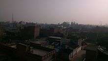
Baberu is a town and a nagar panchayat in Banda district in the state of Uttar Pradesh, India. It is one of four tehsils (subdistricts) of the Banda district.
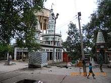
The nearest river that flows to this tehsil is the Yamuna, which is 18 km away from this place. There is a major temple called Madidai Ka Mandir.
It is connected to major cities by paved single lane roads, and is about 130 km from Kanpur and 200 km from Lucknow, the capital of Uttar Pradesh.
Description
Baberu is located at 25°33′N 80°43′E / 25.55°N 80.72°E.[1] It has an average elevation of 112 metres (367 feet).
Baberu's climate is characterized by a hot summer (March-June), pleasant monsoon (July to September and cold winter (October-February).
As of 2001 India census,[2] Baberu had a population of 14,499. Males constitute 54% of the population and females 46%. Baberu has an average literacy rate of 60%, higher than the national average of 59.5%, with 64% of the males and 36% of females literate. 17% of the population is under 6 years of age.
There are a few small local schools. i.e. New Lucknow Public School located at Banda Road is a CBSE pattern English Medium School. Agriculture is the primary industry.
Members of legislative assembly
- 2017 - Chandrapal Kushwaha (Babuji) (BJP)
- 2012 - Vishambhar Singh Yadav
- 2007 - Vishambhar Singh Yadav
- 2002 - Gaya Charan Dinkar
- 1996 - Skiv Shankar
- 1993 - Gaya Charan Dinkar
- 1991 - Gaya Charan Dinkar
- 1989 - Dev Kumar Yadav
- 1985 - Dev Kumar Yadav
- 1980 - Rameshwar Bhai
- 1977 - Dev Kumar Yadav
- 1974 - Dev Kumar Yadav
- 1969 - Durhjan Bhai
- 1967 - Deshraj Singh
- 1962 - Deshraj Singh
- 1957 - Ramsanehi Bhartiya
- 1951 - Ramsanehi Bhartiya
References
- ↑ Falling Rain Genomics, Inc - Baberu
- ↑ "Census of India 2001: Data from the 2001 Census, including cities, villages and towns (Provisional)". Census Commission of India. Archived from the original on 2004-06-16. Retrieved 2008-11-01.
External links
- Location from google maps
- Location from wikimapia
- BSNL Telephone directory search
- Public bus service search from nearest city banda
- Few demographic details
- Banda district
- Sukhdev Singh Lavkush Degree College
- Banda District official Portal
- Baberu MLA
- Directory information
- New Lucknow Public School Banda Road Baberu
[( SUNRISE MAHAVIDHYALAY, BABERU-BANDA )}