Tha Ruea District
| Tha Ruea ท่าเรือ | |
|---|---|
| District | |
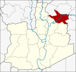 District location in Ayutthaya Province | |
| Coordinates: 14°33′6″N 100°43′39″E / 14.55167°N 100.72750°ECoordinates: 14°33′6″N 100°43′39″E / 14.55167°N 100.72750°E | |
| Country | Thailand |
| Province | Ayutthaya |
| Seat | Tha Chao Sanuk |
| Tambon | 10 |
| Muban | 84 |
| Area | |
| • Total | 106.2 km2 (41.0 sq mi) |
| Population (2000) | |
| • Total | 48,872 |
| • Density | 460.2/km2 (1,192/sq mi) |
| Time zone | UTC+7 (ICT) |
| Postal code | 13130 |
| Geocode | 1402 |
Tha Ruea (Thai: ท่าเรือ, pronounced [tʰâː rɯ̄a̯]) is a district (amphoe) in northeastern part of Ayutthaya Province, central Thailand.
History
The original name of the district was Nakhon Noi. In 1916, it was renamed Tha Ruea to commemorate an important event within the district. When the hunter Bun found the Buddha's footprint in Sara Buri Province, King Songtham travelled by royal barge along the Pa Sak River to worship. He moored his royal barge in the district, and continued his travel overland. His route has since become a royal tradition, as later kings always travelled by this way to worship Buddha's footprint in Wat Phra Phutthabat. The Thai word "tha ruea" means "port" or "pier".
Geography
Neighboring districts are (from the north clockwise) Don Phut, Ban Mo, Sao Hai, Nong Saeng of Saraburi Province, and Phachi and Nakhon Luang of Ayutthaya Province.
Administration
The district is divided into 10 sub-districts (tambon), which are further subdivided into 84 villages (muban).
| No. | Name | Thai | Villages |
|---|---|---|---|
| 1. | Tha Ruea | ท่าเรือ | - |
| 2. | Champa | จำปา | 9 |
| 3. | Tha Luang | ท่าหลวง | 10 |
| 4. | Ban Rom | บ้านร่อม | 9 |
| 5. | Sala Loi | ศาลาลอย | 15 |
| 6. | Wang Daeng | วังแดง | 8 |
| 7. | Pho En | โพธิ์เอน | 6 |
| 8. | Pak Tha | ปากท่า | 8 |
| 9. | Nong Khanak | หนองขนาก | 10 |
| 10. | Tha Chao Sanuk | ท่าเจ้าสนุก | 9 |