Yercaud
| Yercaud | |
|---|---|
| Hill Station | |
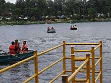
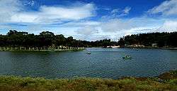 Yercaud Lake | |
 Yercaud | |
| Coordinates: 11°46′46″N 78°12′12″E / 11.7794°N 78.2034°ECoordinates: 11°46′46″N 78°12′12″E / 11.7794°N 78.2034°E | |
| Country | India |
| State | Tamil Nadu |
| District | Salem |
| Area | |
| • Total | 383 km2 (148 sq mi) |
| Elevation | 1,623 m (5,325 ft) |
| Population (2001) | |
| • Total | 36,863 |
| • Density | 96/km2 (250/sq mi) |
| Languages | |
| • Official | Tamil |
| Time zone | UTC+5:30 (IST) |
| Vehicle registration | TN 30 & TN 54 |
| Tamil and English spoken | |
Yercaud is a hill station in Salem District, in Tamil Nadu, India. It is located in the Shevaroys range of hills in the Eastern Ghats. It is situated at an altitude of 1515 metres (4970 ft) above sea level, and the highest point in Yercaud is the Servarayan temple, at 5,326 feet (1,623 m). The hill station is named owing to the abundance of forest near the lake, the name signifying Lake Forest.[1]
The total extent of Yercaud Taluk is 382.67 km2, including reserve forest. The entire county is administered as a township. Yercaud also has a village council.
History
Stone-age implements have been found from the ancient shrine located near Shevaroy Hills ( also known as Shevarayan Hills ), which is about 5 km from the Yercaud lake.[2]
Geography
Climate
| Climate data for Yercaud | |||||||||||||
|---|---|---|---|---|---|---|---|---|---|---|---|---|---|
| Month | Jan | Feb | Mar | Apr | May | Jun | Jul | Aug | Sep | Oct | Nov | Dec | Year |
| Record high °C (°F) | 29 (84) |
32 (90) |
34 (93) |
35 (95) |
34 (93) |
3 (37) |
31 (88) |
30 (86) |
30 (86) |
32 (90) |
31 (88) |
29 (84) |
32 (90) |
| Average high °C (°F) | 22.9 (73.2) |
26.0 (78.8) |
26.9 (80.4) |
28.6 (83.5) |
29.4 (84.9) |
29.4 (84.9) |
26.6 (79.9) |
26.0 (78.8) |
26.1 (79) |
25.0 (77) |
23.7 (74.7) |
23.5 (74.3) |
26.2 (79.1) |
| Average low °C (°F) | 12.4 (54.3) |
13.3 (55.9) |
15.4 (59.7) |
17.7 (63.9) |
18.1 (64.6) |
18.6 (65.5) |
17.6 (63.7) |
17.3 (63.1) |
17.0 (62.6) |
16.4 (61.5) |
14.9 (58.8) |
13.1 (55.6) |
16 (60.8) |
| Record low °C (°F) | 4 (39) |
5 (41) |
6 (43) |
9 (48) |
10 (50) |
8 (46) |
9 (48) |
8 (46) |
5 (41) |
4 (39) |
6 (43) |
6 (43) |
4 (39) |
| Average precipitation mm (inches) | 17 (0.67) |
17 (0.67) |
18 (0.71) |
81 (3.19) |
143 (5.63) |
109 (4.29) |
187 (7.36) |
247 (9.72) |
209 (8.23) |
250 (9.84) |
161 (6.34) |
73 (2.87) |
1,512 (59.52) |
| Source: wunderground.com[3] | |||||||||||||
Demographies
Yercaud has population app. 40,000 people during the 2001 census period. Scheduled Tribal population of Yercaud is 24,449 people.[4]
The total density of the population is 102 people per km2. The increase of population at the rate of 20% and Yercaud being a Rural township it lacks any urban population. The literacy rate in Yercaud is 62% out of the total population.[4]
Transport
Yercaud is situated in Salem district, Tamil Nadu. The nearest city is Salem, 32 km away.TNSTC - Salem operates the buses from Yercaud to major cities. Alternatively, it can also be accessed from Dharmapuri via Kanavaipudur [5]. The nearest airports are Salem Airport at a distance of 38 km. The nearest railway station is Salem Junction – 38 km.
Administration and politics
The Shevaroys as per the local inhabitants consisted of Selanadu (Area south and east of the Shevaroyan Temple) Muttanadu (Land in and around the shevaroyan Temple) and Moganadu (area North of the Temple). In 1842, after the death of the Pattakarar (Tribal Chief) of the Shevaroys there was trouble between the various Malaiyalis. This struggle for succession finally resulted in the British bringing this area under their rule in 1842. The Grange Yercaud was built in the 1820s by M.D. Cockburn & after the Indian Mutiny in 1857, fearing trouble, The Grange, Yercaud was fortified & ramparts built to accommodate gun placements & canons were installed. An underground cellar to store food for over 6 months in the event of a siege was also built & stocked. All Europeans in the area were to assemble at the Grange in the event of an uprising.
Yercaud was a Sub-Taluk up to 14 October 1997. It became a Taluk on 15 October 1997. There are 67 Revenue villages which have been grouped into nine Tariffs for the sake of administration, and each Tariff has one village administrative officer. Yercaud Taluk is divided into three Firkas viz., Yercaud, Vellakkadai and Puthur.
Yercaud has an assembly constituency (Scheduled Tribal Area) is part of Salem (Lok Sabha constituency).[6]. Chitra G of AIADMK is the current MLA.
Education
- Montfort Anglo-Indian Higher Secondary School is a residential institution dating back to 1 June 1917.
References
- ↑ Manual of the administration of the Madras presidency By Madras (India : Presidency)
- ↑ "The Sunday Tribune – Spectrum – Travel". The Tribune. India. Retrieved 2 May 2012.
- ↑ "Historical Weather for Delhi, India". Weather Underground. Retrieved 27 November 2008.
- 1 2 "Microsoft Word – SHB001" (PDF). Retrieved 2 May 2012.
- ↑ "Google Map route".
- ↑ "List of Parliamentary and Assembly Constituencies" (PDF). Tamil Nadu. Election Commission of India. Retrieved 9 October 2008.
External links
| Wikimedia Commons has media related to Yercaud. |
