Sankagiri
| Sankagiri Sankari | |
|---|---|
| city | |
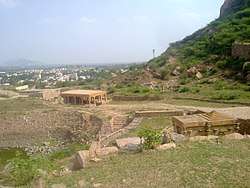 View from Sankagiri Hill | |
 Sankagiri Location in Tamil Nadu, India | |
| Coordinates: 11°29′N 77°52′E / 11.48°N 77.87°ECoordinates: 11°29′N 77°52′E / 11.48°N 77.87°E | |
| Country |
|
| State | Tamil Nadu |
| Population (2001) | |
| • Total | 29,467 |
| Languages | |
| • Official | Tamil |
| Time zone | UTC+5:30 (IST) |
| PIN | 637301 |
| Telephone code | 91-4283 |
| Vehicle registration | TN 52 |
| Website |
www |
Sankagiri or Sankari is a panchayat town in Salem district in the Indian state of Tamil Nadu. It is situated on the National Highway 47, on the Coimbatore - Salem section.
Demographics
As of the 2009 India census,[1] Sankari had a population of 1,34,567. Male constitute 52% of the population and female 48%. Sankari has an average literacy rate of 68%, higher than the national average of 59.5%: Male literacy is 75%, and female literacy is 60%. In Sankari, 10% of the population is under 6 years of age. 40% percent of the people are engaged in agriculture, the remaining are lorry proprietors. Around Sankari many Schools are there. Now the education and the literacy rate of the people around is increasing rapidly.
Early History and Etymology
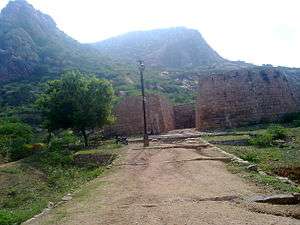
In sangam age Sankagiri was comes under Mazhanadu. It was also called as Kundrathur. Sankagiri Fort was built in the 15th century by the Vijayanagar empire. It was later under the control of Dheeran Chinnamalai and Tippu Sultan before the British annexed it to their territory. Dheeran Chinnamalai was hanged by the British at Sankagiri Fort on 31 July 1805. The fort later served as a British tax storage facility for Kongu Nadu and the town developed around it. Sankagiri, pronounced as San-ka-giri in Tamil. Sangu means conch and Giri means hill.
Economy
The economy of the town was predominantly dependent on agriculture. Over the past decade, truck, cement and steel industries have developed around the town contributing to the economy.There is a cement plant of the renowned India Cements Limited which has a production capacity of 2000T/day and of late lorry industry in sankagiri is fast picking up with trichengode and namakkal,places renowned for truck industry in the country.

Places of interest
- Sankagiri Fort

- Sri Selli Amman Temple
- Sri Someswarar with sowndaranayagiamman Temple
- Sri Sendrayaperumal Hill Temple
- Sri Varadharaja Perumal Temple
- Sri Sakthi Mariyamman Temple
- Sri Kotai Mariyamman Temple
- Orukkamalai Temple
- Morur West Sri Nallapulliyannan Temple
- Pullipalayam Arulmigu Yeni Pali Pachiyamman Temple
- Arulmigu Asura Pachiyamman Temple
- Arulmigu Periya Pachiyamman Temple
- Arulmigu Nallavetti Ayyanarappan Temple
- Konakaatu Muniyappan Temple
Transport
National Highway 47 passes near Sanakagiri connecting the town with Salem and Coimbatore. State's one of the busiest state highway SH 86 passes through Sankagiri. The nearest railway station is Sankari Durg (SGE). The nearest major Railway Junction is Erode and Salem. The nearest airport is Salem (SXV). Tamilnadu state transport corporation's bigger bus depot is situated in the town. India's leading truck manufacturers Ashok Leyland launched a new truck variant SANKAGIRI EXPRESS 3120 named after the auto hub of Tamilnadu Sankagiri as a tribute to the strong bonds that have been forged and nurtured over time between the lorry operators in the region and the Company. It is also an acknowledgement and recognition of a rich relationship of participation and contribution that has fructified into the co-development of new engines and vehicles perfectly suited to the needs of the customers of the region. The dedication of the SANKAGIRI EXPRESS 3120 to the customers of this major auto hub in Tamil Nadu is also to honour the Sankagiri Transport Association that is considered one of the oldest and most influential in the State.
Politics
Sankari assembly constituency is part of Namakkal (Lok Sabha constituency).[2]
See also
References
- ↑ "Census of India 2001: Data from the 2001 Census, including cities, villages and towns (Provisional)". Census Commission of India. Archived from the original on 2004-06-16. Retrieved 2008-11-01.
- ↑ "List of Parliamentary and Assembly Constituencies" (PDF). Tamil Nadu. Election Commission of India. Archived from the original (PDF) on 4 May 2006. Retrieved 9 October 2008.
External links
| Wikimedia Commons has media related to Sankagiri. |