Yakutat Bay
Yakutat Bay is a 29-km-wide (18 mi) bay in the U.S. state of Alaska, extending southwest from Disenchantment Bay to the Gulf of Alaska. "Yakutat" is a Tlingit name reported as "Jacootat" and "Yacootat" by Yuri Lisianski in 1805.

Map of Yakutat Bay.
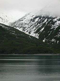
Glacier carved mountains near Yakutat Bay.
Yakutat Bay was the epicenter of two major earthquakes on September 10, 1899, a magnitude 7.4 foreshock and a magnitude 8.0 main shock, 37 minutes apart.[1]
The Shelikhov-Golikov company, precursor of the Russian-American Company, under the management of Alexander Andreyevich Baranov, settled Yakutat Bay in 1795.[2]:15–16 It was known as New Russia, Yakutat Colony, or Slavorossiya.[3]
Other names
Yakutat Bay has had various names.
- James Cook called it "Bering Bay".[2]:15
- Jean-François de La Pérouse, who visited it in 1786, named it "Baie de Monti" for one of his officers.[4]
- The same year, Captain Nathaniel Portlock named it "Admiralty Bay"[4]
- The Spanish called it "Almirantazgo."[4]
- It was also called "Port Mulgrave" when Alessandro Malaspina and José de Bustamante y Guerra sailed into the bay.[5]
- Yuri Lisyansky called it "Jacootat" or "Yacootat" when he visited in 1805.[4]
References
- Historic Earthquakes: Yakutat Bay, Alaska - September 10, 1899 from the U.S. Geological Survey Earthquake Hazards website
- Khlebnikov, K.T., 1973, Baranov, Chief Manager of the Russian Colonies in America, Kingston: The Limestone Press, ISBN 0919642500
- U.S. Geological Survey Geographic Names Information System: Glory of Russia (historical)
- ), Geological Survey (U.S (1901). Bulletin – United States Geological Survey, Volumes 185–187. p. 442.CS1 maint: numeric names: authors list (link)
- Filipino American History Timeline: 1791 from the Alaska Chapter of the Filipino American National Historical Society
External links
- Marine Forecast for Yakutat Bay from the National Weather Service
| Authority control |
|
|---|
This article is issued from Wikipedia. The text is licensed under Creative Commons - Attribution - Sharealike. Additional terms may apply for the media files.