St. Andrews, South Carolina
St. Andrews is a census-designated place (CDP) in Richland County, South Carolina, United States. The population was 20,493 at the 2010 census.[3] It is part of the Columbia, South Carolina Metropolitan Statistical Area.
St Andrews, South Carolina | |
|---|---|
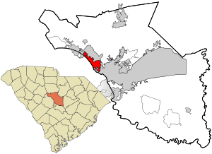 Location in Richland County and the state of South Carolina. | |
| Coordinates: 34°2′37″N 81°5′52″W | |
| Country | United States |
| State | South Carolina |
| County | Richland |
| Area | |
| • Total | 6.4 sq mi (16.5 km2) |
| • Land | 6.3 sq mi (16.4 km2) |
| • Water | 0.04 sq mi (0.1 km2) |
| Elevation | 322 ft (98 m) |
| Population (2010) | |
| • Total | 20,493 |
| • Density | 3,200/sq mi (1,200/km2) |
| Time zone | UTC−5 (Eastern (EST)) |
| • Summer (DST) | UTC−4 (EDT) |
| FIPS code | 45-62395[1] |
| GNIS feature ID | 1867529[2] |
History
The Pine Grove Rosenwald School was listed on the National Register of Historic Places in 2009.[4]
Geography
St. Andrews is located at 34°2′37″N 81°5′52″W (34.043551, -81.097854).[5]
According to the United States Census Bureau, the CDP has a total area of 6.4 square miles (16.5 km2), of which 6.3 square miles (16.4 km2) is land and 0.04 square miles (0.1 km2), or 0.33%, is water.[3]
Demographics
At the 2000 census there were 21,814 people in 10,497 households, including 5,091 families, in the CDP. The population density was 3,167.8 people per square mile (1,222.4/km²). There were 11,398 housing units at an average density of 1,655.2 per square mile (638.7/km²). The racial makeup of the CDP was 43.05% White, 52.69% African American, 0.25% Native American, 1.83% Asian, 0.07% Pacific Islander, 0.83% from other races, and 1.27% from two or more races. Hispanic or Latino of any race were 1.98%.[1]
Of the 10,497 households 24.1% had children under the age of 18 living with them, 28.8% were married couples living together, 16.1% had a female householder with no husband present, and 51.5% were non-families. 40.5% of households were one person and 5.6% were one person aged 65 or older. The average household size was 2.07 and the average family size was 2.83.
The age distribution was 21.2% under the age of 18, 15.8% from 18 to 24, 36.8% from 25 to 44, 17.6% from 45 to 64, and 8.6% 65 or older. The median age was 30 years. For every 100 females, there were 86.3 males. For every 100 females age 18 and over, there were 82.8 males.
The median household income was $34,551 and the median family income was $42,088. Males had a median income of $31,114 versus $25,329 for females. The per capita income for the CDP was $20,201. About 10.5% of families and 13.1% of the population were below the poverty line, including 20.5% of those under age 18 and 6.2% of those age 65 or over.
Education
St. Andrews has a public library, a branch of the Richland County Library.[6]
References
- "U.S. Census website". United States Census Bureau. Retrieved 2008-01-31.
- "US Board on Geographic Names". United States Geological Survey. 2007-10-25. Retrieved 2008-01-31.
- "Geographic Identifiers: 2010 Demographic Profile Data (G001): St. Andrews CDP, South Carolina". U.S. Census Bureau, American Factfinder. Archived from the original on February 12, 2020. Retrieved January 15, 2013.
- "National Register Information System". National Register of Historic Places. National Park Service. July 9, 2010.
- "US Gazetteer files: 2010, 2000, and 1990". United States Census Bureau. 2011-02-12. Retrieved 2011-04-23.
- "Locations & Hours". Greenville County Library System. Retrieved 13 June 2019.
Municipalities and communities of Richland County, South Carolina, United States | ||
|---|---|---|
| Cities | 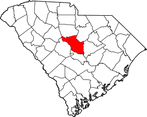 Map of South Carolina highlighting Richland County | |
| Towns | ||
| CDPs | ||
| Unincorporated communities | ||
| Unincorporated community | ||
| Footnotes | ‡This populated place also has portions in an adjacent county or counties | |