Cayce, South Carolina
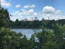
Cayce (pronounced KAY-see) is a city in Lexington and Richland counties in the U.S. state of South Carolina, along the Congaree River. The population was 12,528 at the 2010 census.[3] It is part of the Columbia, South Carolina, Metropolitan Statistical Area.
Cayce, South Carolina | |
|---|---|
 City Hall | |
| Motto(s): "A new kind of city" | |
 Location in Richland County and the state of South Carolina. | |
| Coordinates: 33°57′48″N 81°4′0″W | |
| Country | United States |
| State | South Carolina |
| County | Lexington and Richland |
| Government | |
| • Mayor | Elise Partin |
| Area | |
| • Total | 17.4 sq mi (45.1 km2) |
| • Land | 16.6 sq mi (43.1 km2) |
| • Water | 0.8 sq mi (2.0 km2) |
| Elevation | 240 ft (73 m) |
| Population (2010) | |
| • Total | 12,528 |
| • Density | 720/sq mi (280/km2) |
| Time zone | UTC−5 (Eastern (EST)) |
| • Summer (DST) | UTC−4 (EDT) |
| ZIP code | 29033 |
| Area code(s) | 803, 839 |
| FIPS code | 45-12655[1] |
| GNIS feature ID | 1247197[2] |
| Website | www |
Cayce lies mostly across the Congaree River from the state capital of Columbia, with a newly annexed section on the Richland County side awaiting development. Because both it and the neighboring city of West Columbia share road names and schools, they are sometimes referred to jointly as "Cayce-West Columbia". However, they are politically separate cities.
The Congaree River has always played a dominant role in Cayce's development. Cayce and other local governments jointly developed the Riverwalk along the Congaree, which provides walking, jogging, and nature observation opportunities. Development on both sides of the river is an important factor driving the city's economy.
History
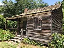
What was to become Cayce was home to Native Americans for at least 12,000 years;[4] This includes what is now known as the Manning Archeological Site, the SAM Site, and the Taylor Site.[5]
Hernando de Soto reached the area in 1540, encountering a large Indian village at Congaree Creek, where Cayce now stands.[4] Near the end of the 17th century, explorers such as John Lawson visited and documented his trip.[4] In 1718, the English built the first permanent fort, becoming the first structure built in the Midlands. A second fort was built on the river in 1748. These forts were referred to as Congaree Fort #1 and Congaree Fort #2,[4] and became part of the Congarees Site in 1974.[5][6]
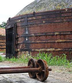
The Guignard Brick Works were established on the west bank of the Congaree in 1803 and remained active for nearly two centuries.[4]
The town includes the area that was once Granby, once the county seat and a flourishing community before it was abandoned by the end of the first quarter of the nineteenth century.[7]
The town was incorporated in 1914 and named for local businessman William J. Cayce.
Economy
Cayce is the home of SCANA, the parent company of South Carolina Electric & Gas Company, Carolina Gas Transmission, Cayce Capital, PSNC Energy, and other subsidiaries operating in the Southeastern United States.
Transportation
South Carolina Highway 2 is within city limits; Cayce is traversed by I-26 and I-77,
Columbia Metropolitan Airport (IATA:CAE) is adjacent to the city limits.
The Columbia Subdivision, a railroad line owned by CSX Transportation, passes through Cayce; it was the site of a train collision in February 2018.
Education
Cayce is home to Brookland-Cayce High School, Cayce Elementary School, and Cyril B. Busbee Creative Arts Academy.
Geography
Cayce is located at 33°57'48" North, 81°3'60" West (33.963203, -81.066596),[8] within the Midlands of South Carolina.
According to the United States Census Bureau, the city has a total area of 17.4 square miles (45.1 km2), of which 16.6 square miles (43.1 km2) is land and 0.77 square miles (2.0 km2), or 4.22%, is water.[3]
Demographics
| Historical population | |||
|---|---|---|---|
| Census | Pop. | %± | |
| 1920 | 746 | — | |
| 1930 | 1,267 | 69.8% | |
| 1940 | 1,476 | 16.5% | |
| 1950 | 3,294 | 123.2% | |
| 1960 | 8,517 | 158.6% | |
| 1970 | 9,967 | 17.0% | |
| 1980 | 11,701 | 17.4% | |
| 1990 | 11,163 | −4.6% | |
| 2000 | 12,150 | 8.8% | |
| 2010 | 12,528 | 3.1% | |
| Est. 2019 | 14,009 | [9] | 11.8% |
| U.S. Decennial Census[10] | |||
As of the census[1] of 2000, there were 12,150 people in the city, organized into 5,133 households and 3,079 families. The population density was 1,114.6 people per square mile (430.4/km2). There were 5,517 housing units at an average density of 506.1 per square mile (195.4/km2). The racial makeup of the city was 74.55% White, 22.50% African American, 1.08% Asian, 0.26% Native American, 0.15% Pacific Islander, 0.67% from other races, and 0.80% from two or more races. 1.28% of the population were Hispanic or Latino of any race.
There were 5,133 households, out of which 24.4% had children under the age of 18 living with them, 41.8% were married couples living together, 14.5% had a female householder with no husband present, and 40.0% were non-families. 29.0% of all households were made up of individuals, and 10.8% had someone living alone who was 65 years of age or older. The average household size was 2.36 and the average family size was 2.89.
In the city, the population was spread out, with 20.7% under the age of 18, 14.1% from 18 to 24, 28.6% from 25 to 44, 21.9% from 45 to 64, and 14.7% who were 65 years of age or older. The median age was 36 years. For every 100 females, there were 86.2 males. For every 100 females age 18 and over, there were 81.8 males.
The median income for a household in the city was $35,850, and the median income for a family was $43,560. Males had a median income of $30,317 versus $24,408 for females. The per capita income for the city was $17,745. 17.0% of the population and 9.9% of families were below the poverty line. Out of the total population, 20.0% of those under the age of 18 and 8.2% of those 65 and older were living below the poverty line.
References
- "U.S. Census website". United States Census Bureau. Retrieved 2008-01-31.
- "US Board on Geographic Names". United States Geological Survey. 2007-10-25. Retrieved 2008-01-31.
- "Geographic Identifiers: 2010 Demographic Profile Data (G001): Cayce city, South Carolina". U.S. Census Bureau, American Factfinder. Archived from the original on February 12, 2020. Retrieved January 14, 2013.
- ""Cradle of the Midlands": A Comprehensive History". City of Cayce. Archived from the original on 2016-01-17. Retrieved 2014-11-02.
- "National Register Information System". National Register of Historic Places. National Park Service. July 9, 2010.
- "Congarees Site" (PDF). National Register of Historic Places Inventory - Nomination Form. Retrieved 2014-11-02.
- Claudette Holliday (29 August 2008). Remembering Lexington, South Carolina: Good Stewards in a New Land. Arcadia Publishing Incorporated. p. 31. ISBN 978-1-62584-881-9. Retrieved 16 September 2018.
- "US Gazetteer files: 2010, 2000, and 1990". United States Census Bureau. 2011-02-12. Retrieved 2011-04-23.
- "Population and Housing Unit Estimates". Retrieved May 21, 2020.
- "Census of Population and Housing". Census.gov. Retrieved June 4, 2015.
External links
| Wikimedia Commons has media related to Cayce, South Carolina. |
Municipalities and communities of Lexington County, South Carolina, United States | ||
|---|---|---|
| Cities | 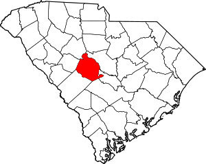 Map of South Carolina highlighting Lexington County | |
| Towns | ||
| CDPs | ||
| Ghost town | ||
| Footnotes | ‡This populated place also has portions in an adjacent county or counties | |
Municipalities and communities of Richland County, South Carolina, United States | ||
|---|---|---|
| Cities | 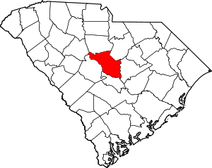 Map of South Carolina highlighting Richland County | |
| Towns | ||
| CDPs | ||
| Unincorporated communities | ||
| Unincorporated community | ||
| Footnotes | ‡This populated place also has portions in an adjacent county or counties | |
| Authority control |
|
|---|