Legarda Street
Legarda Street is a short street located in Sampaloc district in Manila, Philippines. It crosses through the eastern section of the University Belt area in a generally east–west orientation between the Nagtahan Interchange in Sampaloc and the intersection with Nepomuceno Street and Concepcion Aguila Street in Quiapo. It is served by Legarda station of the Manila Line 2.
| |
|---|---|
| Calle Alix | |
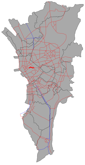 The route of Legarda Street in Metro Manila. Legarda Street is highlighted in red. | |
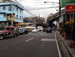 Legarda Street towards Magsaysay Boulevard | |
| Route information | |
| Length | 1.4 km (0.9 mi) |
| Component highways |
|
| Major junctions | |
| From | |
| |
| To | Nepomuceno Street in Quiapo |
| Location | |
| Major cities | Manila |
| Highway system | |
| |
.svg.png)

The street was named after Filipino legislator and resident commissioner to the U.S., Benito Legarda y Tuason.[1] It was formerly called Calle Alix, after Real Audiencia of Manila magistrate of the 1860s, José María Alix y Bonache.[2][3]
Route
Legarda Street commences at the Legarda Flyover of the Nagtahan Interchange as a westward continuation of Magsaysay Boulevard from Santa Mesa district. It heads due west, traversing the southern edge of Sampaloc and skirting the northern boundary of San Miguel. After crossing Figueras Street, Legarda bends to the southwest following the course of Estero de Alix (Alix Creek). It intersects with Recto Avenue–Mendiola Street, wherein majority of its traffic turn towards Recto Avenue serving as a major continuation westward, and San Rafael Street before terminating and briefly converging with the junction at Nepomuceno Street (formerly Tanduay Street) in Quiapo district before it transitions again as P. Casal Street heading into San Miguel and Ayala Bridge to Ermita on the southern bank of the Pasig River.
Notable establishments on Legarda Street include Arellano University, Sta. Catalina College, the main campus of ABE International Business College, San Lorenzo Ruiz Student Catholic Center, Mendiola Theater and the Department of Social Welfare and Development–NCR Office.
Intersections
The entire route is located in Manila.
| km[4] | mi | Destinations | Notes | ||
|---|---|---|---|---|---|
| Nepomuceno Street | Transition into Nepomuceno Street westward towards | ||||
| Cruzada Street | Eastbound only | ||||
| San Rafael Street | Unsignaled intersection. (Formerly signaled intersection) | ||||
| Traffic light intersection. Recto Avenue serves as continuation westward. | |||||
| F. Dalupan Street (Gastambide Street) | Westbound only | ||||
| M. V. Delos Santos Street | Westbound only | ||||
| D. Santiago Street | Westbound only | ||||
| Delgado Street | Westbound only | ||||
| Main Street | Westbound only | ||||
| Legarda Station Access Road Entrance | Eastbound only. Access to Legarda station | ||||
| J. Figueras Street | Traffic light intersection. | ||||
| Manrique Street | Westbound only | ||||
| Legarda Station Access Road Exit | Eastbound only | ||||
| Mariano Fortunato Jhocson Street | Westbound only | ||||
| West end of Legarda Flyover | |||||
| Sta. Teresita Street | Westbound only | ||||
| 4.205 | 2.613 | Nagtahan Interchange. Traffic light intersection. Continues eastward as | |||
1.000 mi = 1.609 km; 1.000 km = 0.621 mi
| |||||
See also
References
- Did you know? Legarda Street published by the Philippine Daily Inquirer; accessed 2013-11-01.
- Legarda Street published by Historiles.com; accessed 2013-11-01.
- Full text of "Guía oficiál de España" published by Archive.org; accessed 2013-11-01.
- "North Manila". 2016 DPWH data. Department of Public Works and Highways. Archived from the original on August 13, 2017. Retrieved August 13, 2017.