Recto Avenue
Claro M. Recto Avenue, more popularly known as simply Recto Avenue, is the principal commercial thoroughfare in north central Manila, Philippines. It spans seven districts just north of the Pasig River in what is generally considered Manila's old downtown area.
| |
|---|---|
 The route of Recto Avenue in Metro Manila. Recto Avenue is highlighted in red. | |
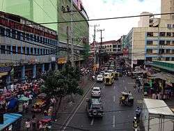 Recto Avenue looking west towards Divisoria from Abad Santos Avenue overpass | |
| Route information | |
| Length | 3.2 km (2.0 mi) |
| Component highways |
|
| Major junctions | |
| West end | |
| Juan Luna Street | |
| East end | |
| Location | |
| Districts | Binondo, Quiapo, Sampaloc, San Nicolas, Santa Cruz, Tondo |
| Highway system | |
| |
.svg.png)


Recto's western terminus is at an intersection with Mel Lopez Boulevard (Radial Road 10) at the district boundaries of Tondo and San Nicolas close to the Manila North Harbor. It runs northeast before curving to the east at Juan Luna Street and Estero de Binondo. It then passes through the Divisoria shopping area of Manila south of the Tutuban railway station until it curves southeast past the Antonio Rivera Street junction. East of Rizal Avenue and Santa Cruz district, Recto intersects with the streets of the University Belt area of Quiapo and Sampaloc before terminating at Legarda Street and Mendiola Street at the district boundaries of Quiapo and Sampaloc.
Line 2 runs along its Rizal Avenue–Legarda Street segment. It has a short extension into San Miguel and the gated Malacañang Palace compound as Mendiola Street.
History
Recto Avenue was developed by sections in various time periods during the course of Spanish rule. The main section leading to the coast in San Nicolas and Tondo from Binondo was named Paseo de Azcárraga, after the Spanish-Filipino Prime Minister, Marcelo Azcárraga Palmero.
In the Santa Cruz district, the road was divided into Calle General Izquierdo, Calle Paz and Calle Bilibid because of the three creeks (esteros) that ran through the district. In Sampaloc, the road was named Calle Iris which terminated at Calle Alix (now Legarda Street).[1] The name Paseo de Azcárraga was extended to include the full length of the street which was also called Paseo de Felipe at one point (after King Philip II of Spain). Finally, in 1961, the avenue was given its present name in honor of the Filipino senator, Claro Mayo Recto.[2]
On July 7, 1892, in a building numbered 72 Calle Azcárraga, at the intersection with Calle Sagunto (now Santo Cristo) in Tondo, Andres Bonifacio founded the revolutionary society named Katipunan.[3]
In the early 1900s, the avenue was a theater-and-restaurant row, with Teatro Libertad and Zorrilla Theatre attracting the well-dressed crowd to zarzuela shows and operas that ran on weekends.[4]
Transportation
Recto Avenue is a major stop on three lines of the Metro Manila Transit System.
- Doroteo Jose station at Rizal Avenue served by Line 1.
- Recto station at Rizal Avenue served by Line 2.
- Tutuban railway station at Dagupan Street served by PNR.
The route is also served by several bus companies and jeepneys. Additional stations will be built along the road as part of the Line 2 west expansion project.[5]
Intersections
(2017-07-13).jpg)
The entire route is located in Manila.
| km | mi | Destinations | Notes | ||
|---|---|---|---|---|---|
| Eastern terminus. Continues eastward as Mendiola Street. Access to San Miguel district & Malacañang Palace; Nagtahan Interchange & Rizal Park via Legarda Street. | |||||
| San Sebastian Street | One-way road. | ||||
| Sergio H. Loyola Street | Traffic light intersection. | ||||
| Matapang Street | Eastbound only. | ||||
| Nicanor Reyes (Morayta) Street | Traffic light intersection. Access to | ||||
| Severino Street | Eastbound only. | ||||
| Coromina Street | Eastbound only | ||||
| Diamond interchange. No access on opposite sides of the road. | |||||
| Evangelista Street | One-way to Recto Avenue; eastbound only. | ||||
| Calero Street | One-way from Recto Avenue; eastbound only. | ||||
| Oroquieta Road | One-way from Recto Avenue; westbound only. Access to LRT-1 Doroteo Jose station. Various provincial buses have terminals near this vicinity. | ||||
| Traffic light intersection. Southbound goes to Intramuros, Ermita & Manila City Hall; Northbound goes to Monumento & Grace Park in Caloocan. | |||||
| Florentino Torres Street | One-way to Recto Avenue; Eastbound only. | ||||
| Tomás Mapúa Street | Traffic light intersection. One-way only. | ||||
| San Bernardo Street | Eastbound only. | ||||
| Severino Reyes Street | Westbound only. | ||||
| Teodora Alonzo Street | Traffic light intersection. | ||||
| Benavidez Street | Traffic light intersection. One-way only. | ||||
| Masangkay Street | Traffic light intersection. One-way only. | ||||
| Aguilar Street | Opposite segments accessible via nearby roads. | ||||
| Sanchez Street | One way from Recto Avenue; eastbound only. | ||||
| Traffic light intersection. Northbound goes to Tondo, Monumento & Camanava area via | |||||
| Narra Street | Westbound only. | ||||
| Antonio Rivera Street | Westbound only. | ||||
| Roman Street | Eastbound only. | ||||
| Bonifacio Drive | Westbound only. Access to Tutuban Center & PNR Tutuban station. | ||||
| Soler Street / Dagupan Street Extension | Unsignaled intersection. | ||||
| Juan Luna Street | Access to opposite segments via nearby roads. | ||||
| Ilaya Street | Access to opposite segments via nearby roads. | ||||
| Tabora Street | Eastbound only. | ||||
| Carmen Planas Street | Access to opposite segments via nearby roads. | ||||
| Sto. Cristo Street | Unsignaled intersection. | ||||
| Elcano Street | Access to opposite segments via nearby roads. | ||||
| Asuncion Street | Unsignaled intersection. | ||||
| Saint Mary Street / Camba Street | |||||
| Angalo Street | Accessible only to bicycles, motorcycles, pedicabs & pedestrians. | ||||
| Sevilla Street | |||||
| Western terminus. Unsignaled intersection. Southwest road continues to the Manila International Container Terminal (MICT). Northbound goes to Malabon & Navotas, southbound goes to Intramuros & Ermita districts. | |||||
| 1.000 mi = 1.609 km; 1.000 km = 0.621 mi | |||||
Landmarks

_(2014).JPG)
- Shopping malls
- 168 Shopping Mall
- 999 Shopping Mall
- D8 Mall (formerly Benisons Shopping Center)
- Ever Malls Manila Plaza
- Isetann Cinerama Recto
- Lucky Chinatown
- Odeon Terminal Mall
- Tutuban Center
- Universities and colleges
- Access Computer College - Recto
- Far Eastern University
- Informatics College - Recto
- Philippine College of Health Sciences
- San Sebastian College – Recoletos
- STI Colleges Recto
- University of the East
- Other notable buildings
- Basilica of San Sebastian, Manila
- Manila City Jail (Old Bilibid Prison)
- Manila Grand Opera Hotel
- Tutuban railway station
See also
- List of renamed streets in Manila
References
- Did you know? Recto Avenue published by the Philippine Daily Inquirer; accessed 2013-10-15.
- Old Manila streets lose names to politicians Archived 2010-07-17 at the Wayback Machine published by the Philippine Daily Inquirer; accessed 2013-10-15.
- "The Philippines, the land of palm and pine : an official guide and hand book (1912)". Manila Bureau of Print. Retrieved 11 July 2014.
- The Americanization of Manila, 1898-1921. University of the Philippines Press. Retrieved 11 July 2014.
- "NEDA approves P27.9 billion worth of projects". CNN Philippines. Retrieved 2019-08-01.
| Wikimedia Commons has media related to Recto Avenue. |