Tayuman Street
Tayuman Street is a four-lane east-west street in northern Manila, Philippines. It stretches 1.6 kilometers (1 mile) from the old San Lazaro Hippodrome in Santa Cruz to Barrio Pritil in Tondo district. The street is designated as part of Circumferential Road 2.
| |
|---|---|
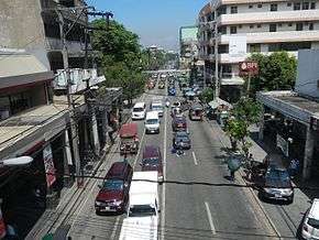 Tayuman Street view from Tayuman LRT Station | |
| Route information | |
| Length | 1.6 km (1.0 mi) |
| Component highways |
|
| Major junctions | |
| From | Lacson Avenue in Santa Cruz |
| Rizal Avenue Abad Santos Avenue | |
| To | Juan Luna Street in Tondo |
| Location | |
| Major cities | City of Manila |
| Highway system | |
| |
.svg.png)
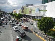
Tayuman begins as a continuation of Consuelo Street at an intersection with Lacson Avenue in Santa Cruz district fronting SM City San Lazaro. It crosses Rizal Avenue, passing underneath the Tayuman LRT Station where it continues past the headquarters of the Department of Health into the residential areas of Santa Cruz and Tondo. The street ends at Juan Luna Street near Puregold Tayuman supermarket.
The street was named after tayum, a type of indigo plant.[1] It extends west from Juan Luna Street into Barrio Magsaysay and the Manila North Harbor in Tondo as Capulong Street.
Route description
Tayuman Street is designated a national secondary road, wholly with the route number N140. The road has four lanes, with two per direction, are mostly lined with side streets and local businesses.
Numerous establishments line the road, like the Department of Health Central Office, Puregold Tayuman branch, Sentro ng Karunungan Library,[2] Archdiocesan Shrine of Espiritu Santo, Immaculate Conception Parish Church and Tayuman Commercial Center. San Lazaro Tourism and Business Park and SM City San Lazaro, both standing on the former location of the San Lazaro Racetrack, which moved to Carmona, Cavite, lies on the east end of the street. Schools also line the street, like the Andres Bonifacio Elementary School (Tayuman cor Ipil Street), Espiritu Santo Parochial School, Manila Cathedral School, and Rizal Elementary School.
Jeepney Route
Tayuman Street
- Tayuman - Pritil
- Tayuman - Lardizabal
- Blumentritt - Divisoria
- Rivera - Raon
Intersections Jeepney Route
- Gasak - Recto (Oroquieta Street)
- Navotas - Recto (Oroquieta Street)
- MCU - Divisoria (Abad Santos Avenue)
- Malanday - Divisoria (Abad Santos Avenue)
- Malinta - Divisoria (Abad Santos Avenue)
Intersections
| Province | City/Municipality | km | mi | Destinations | Notes |
|---|---|---|---|---|---|
| Santa Cruz, Manila | 8.006 | 4.975 | SM City San Lazaro | ||
| Pedro Guevarra Street | |||||
| Sulu Street | |||||
| Felix Huertas Street | Traffic light intersection. | ||||
| Manuel Hizon Street | |||||
| Oroquieta Road | Traffic light intersection. Espiritu Santo Parochial School | ||||
| Maria Natividad Street | Tayuman Commercial Center | ||||
| Traffic light intersection. | |||||
| Manila Light Rail Transit System Line 1 (Tayuman station) | |||||
| Anacleto Street | Department of Health | ||||
| Tomas Mapua Street | |||||
| Makata Street | |||||
| Severino Reyes Street | |||||
| Kusang Loob Street | Land Transportation Office | ||||
| Ipil Street | Andres Bonifacio Elementary School | ||||
| E.Manalo Street (Formerly known as Apitong Street) | Iglesia ni Cristo Congregation | ||||
| Dapdap Street | |||||
| Tondo, Manila | Yakal St. (Riverside) | Estero de San Lazaro | |||
| 1.050 | 0.652 | Almeda Street | |||
| Traffic light intersection | |||||
| Antonio Rivera Street | Novo Department Store | ||||
| Katamanan Street | Immaculate Conception Parish Church, Missionaries of Charity of Joy | ||||
| Imaculada Street | Missionaries of Charity of Joy, TESDA, Manila Cathedral School | ||||
| Railroad crossing with PNR Metro South Commuter Line | |||||
| Dagupan Extension | |||||
| G. Perfecto Street | |||||
| Perfecto Street | |||||
| Prudencia Street | |||||
| 6.416 | 3.987 | Juan Luna Street | Puregold Tayuman, Traffic light intersection. Road continues west as Capulong Street | ||
| 1.000 mi = 1.609 km; 1.000 km = 0.621 mi | |||||
See also
- Major roads in Manila
References
- Did you know? Tayuman Street Archived 2015-06-11 at the Wayback Machine published by the Philippine Daily Inquirer; accessed 2013-10-08.
- Sentro ng Karunungan (Tondo Congressional) Library published by NLP.gov.ph; accessed 2013-10-08.
| Wikimedia Commons has media related to Tayuman Street. |