Circumferential Road 2
Circumferential Road 2 is a 2- to 12-lane network of roads and segments that altogether form the second circumferential road that acts as a beltway of the City of Manila. It is the second circumferential road, labeled C-2 in the Manila Arterial Road System. It is a route running inside the city of Manila proper, passing through the districts of Tondo, Santa Cruz, Sampaloc, Santa Mesa, Paco, Pandacan, and Malate.[1][2]
| ||||
|---|---|---|---|---|
| Circumferential Road 2 | ||||
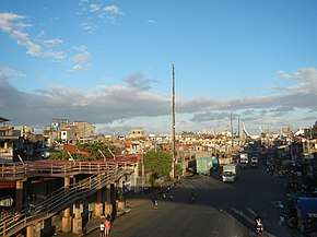 Capulong Street, a segment of C-2 Road, in Tondo | ||||
| Route information | ||||
| Maintained by Department of Public Works and Highways and Metro Manila Development Authority | ||||
| Length | 10.0 km (6.2 mi) | |||
| Major junctions | ||||
| North end | ||||
| ||||
| South end | ||||
| Location | ||||
| Major cities | Manila | |||
| Highway system | ||||
| ||||
.svg.png)
The entire route is also a component of National Route 140 (N140) of the Philippine highway network.
History
The development of the major road network in Manila was first conceived in the Metropolitan Thoroughfare Plan of 1945, predicting that the metropolis in the 1940s will expand further to the shorelines of Laguna de Bay. The plan proposed the laying of circumferential roads 1 to 6 and radial roads 1 to 10.[3]
Since roads were already existing, the concept was to just connect short road segments to form C-2. To be joined are Calle Capulong, Calle Tayuman, Governor Forbes, Calle Nagtahan found north of the Pasig River, and Calle Canonigo in the south bank of the Pasig. The Nagtahan Bridge, the widest bridge crossing the Pasig River until it was surpassed by the Guadalupe Bridge in 1963, connected these two sections.
The older roads date back to the early 19th century under Spanish rule. Calle Canonigo (now Quirino Avenue Extension) was laid out to connect Plaza Dilao / Paco railroad station to Calle Isaac Peral (now United Nations Avenue).[4] The road perpendicular to Canonigo leading to Pasig River was a narrow street called Calle Luengo in Pandacan.[5]
A 1934 map of Manila by the YMCA shows Calle Tayuman starts at Calle Sande / Juan Luna and ends near the San Lazaro Hippodrome. The road then connects to Calle Governor Forbes (now Lacson Avenue) which stretches until Calle Lealtad (now Fajardo). Calle Nagtahan connects the Santa Mesa Rotonda up to the Pasig River. South of the Pasig, only Calle Canonigo was existing. Harrison Boulevard (now Quirino Avenue) was then built during the Commonwealth period to connect Calle Herrán (now Pedro Gil Street) to Dewey Boulevard (now Roxas Boulevard). Eventually, Calle Luego was extended to Calle Herran.
Route
Capulong Street
Also known as the C-2 Road, Capulong Street starts from Mel Lopez Boulevard and ends in Juan Luna Street. It becomes the Tayuman Street after crossing Juan Luna Street. It is the main thoroughfare of the Tondo district of Manila.
Tayuman Street
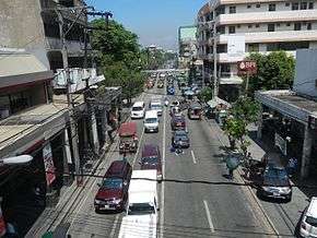
Tayuman Street is a 4-lane main thoroughfare of the districts of Tondo and Santa Cruz. It starts from the Juan Luna Street and ends in a junction with Lacson Avenue. The entire road is considered as a part of the C-2 Road.
Lacson Avenue

Formerly known as Governor Forbes Avenue, the C-3 segment of Lacson Avenue starts from the junction of Tayuman and Consuelo Streets in Santa Cruz and ends at the Nagtahan Interchange at the boundaries of Sampaloc and Santa Mesa, skirting the old San Lazaro Hippodrome.
Nagtahan Street
Nagtahan Street connects the Nagtahan Interchange with Mabini Bridge (Nagtahan Bridge) within the district of Santa Mesa.[6]
Quirino Avenue
Quirino Avenue starts from the southern end of Mabini Bridge at the junction of Paz Mendoza Guazon (formerly Otis) and Jesus Streets in Paco and ends at Roxas Boulevard in Manila.[7]
Major Intersections
Intersections indicated in bold are intersections with stoplights.
Capulong and Tayuman Streets
- Mel Lopez Boulevard (Radial Road 10)
- Raxa Bago Street (F.P. Yuseco Street)
- Juan Luna Street
- Dagupan Street
- Abad Santos Avenue
- Rizal Avenue
- Oroquieta Street (one way)
Lacson Avenue
- Aragon Street, Alfonso Mendoza Street
- Maria Clara Street
- Laong Laan Road, Dimasalang Street (5-way Intersection)
- Dapitan Street (one way)
- España Boulevard
- M. Earnshaw Street
- Sergio H. Loyola Street (one way)
- Fajardo Street (one way)
- Nagtahan Interchange: junctions of J.P. Laurel Street, Legarda Street, Magsaysay Boulevard, Nagtahan Street, and Lacson Avenue, triple grade separations.
Quirino Avenue
- Paz Mendoza Guazon Street, Jesus Street
- Tomas Claudio Street
- Quirino Avenue Extension (Plaza Dilao Partial Roundabout)
- Pedro Gil Street
- South Luzon Expressway (Osmeña Highway)
- Singalong Street (one way)
- Angel Linao Street (one way)
- San Marcelino Street (one way)
- Leon Guinto Street (one way)
- San Andres Street, Taft Avenue (6-way Intersection)
- Leveriza Street
- Adriatico Street
- Mabini Street (one way)
- M.H. Del Pilar Street (one way)
- Roxas Boulevard
See also
References
- Page Nation. "President Elpidio Quirino Avenue". Creative-commons. Retrieved 26 July 2019.
- Simbianize.com. "Drivers Tell Horror Stories About Quirino Avenue". Simbianize.com. Archived from the original on 8 August 2016. Retrieved 26 July 2019.
- "PH, JICA prepares new Metro Manila road network development plan" (PDF). Wallace Business Forum - Philippine Analyst. July 2013. Retrieved July 26, 2019.
- History of San Fernando de Dilao Archived 2013-07-24 at the Wayback Machine published by the Roman Catholic Archdiocese of Manila; accessed 2013-10-09.
- 1945 Map of Central Manila published by BattleofManila.org; accessed 2013-10-09.
- Google (19 June 2020). "Nagtahan St" (Map). Google Maps. Google. Retrieved 19 June 2020.
- Citiatlas Metro Manila. Asiatype. 2002. p. 183. ISBN 978-971-91719-5-9.