Makati Avenue
Makati Avenue (Filipino: Abenida Makati) is a major commercial thoroughfare in Makati, Metro Manila, Philippines. It forms the eastern border of Ayala Triangle and is one of the three main avenues of the Makati Central Business District. The avenue runs in a somewhat north-south diagonal direction almost parallel with Epifanio de los Santos Avenue (EDSA). It passes through two distinct neighborhoods of the city: the Makati CBD and the old Makati Población. At its northern end lies the older part of Makati starting from the Makati-Mandaluyong Bridge and J.P. Rizal Avenue. It continues through Población to Gil Puyat Avenue, marking the southern edge of the old district. South of Gil Puyat onto the CBD, the avenue becomes more commercial and upscale. The shopping hub of Ayala Center and Arnaiz Avenue lie at its southern end.
| Makati Avenue | |
|---|---|
 | |
| Route information | |
| Length | 2.3 km (1.4 mi) |
| Major junctions | |
| From | Makati-Mandaluyong Bridge in Poblacion |
| J.P. Rizal Avenue Kalayaan Avenue Gil Puyat Avenue Paseo de Roxas Ayala Avenue | |
| To | Arnaiz Avenue in San Lorenzo |
| Location | |
| Provinces | Metro Manila |
| Major cities | Makati |
| Highway system | |
| |
Makati Avenue has two lanes each way in the Poblacion area, widening to three or four in the CBD. It has a short extension into the gated San Lorenzo Village as San Lorenzo Drive.
History
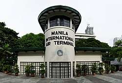
The avenue served as the primary access road to the old Nielson Field airport from San Pedro de Macati. It was known as Culi-Culi Road which also led to the barrio of Culi-Culi (now Pio del Pilar) just west of Nielson Field.[1] When the airport was closed down after World War II, its two runways were converted into wide roads known today as Ayala Avenue and Paseo de Roxas. The airport's control tower was preserved and is now a library called Filipinas Heritage Library.[2] This library is located along the avenue at the southeast corner of Ayala Triangle.
Makati Avenue, particularly its northern segment in Poblacion, has a history of prostitution. The areas around P. Burgos Street with its nightclubs, bars and budget hotels are considered by many as the red light district of Makati.[3][4] At present, however, the area is undergoing gentrification with the completion of several new commercial developments including the Century City mall and complex.[5]
Intersections
The entire route is located in Makati.
| km | mi | Destinations | Notes | ||
|---|---|---|---|---|---|
| Arnaiz Avenue | Southern terminus. Traffic light intersection. Continues south into San Lorenzo Village as San Lorenzo Drive. | ||||
| Esperanza Street | Entrance only to Makati Avenue southbound | ||||
| Palm Drive | Traffic light intersection. Access to Glorietta and Greenbelt complexes. | ||||
| Parkway Drive | Traffic light intersection. Access to Glorietta complex. | ||||
| Dela Rosa Street | Southbound access to Legazpi Village | ||||
| Ayala Avenue | Traffic light intersection | ||||
| Santo Tomas Street | Access to Urdaneta Village and The Peninsula Manila | ||||
| Paseo de Roxas | Traffic light intersection | ||||
| H.V. Dela Costa Street | Traffic light intersection. Southbound access to Salcedo Village. | ||||
| Buendia Extension Access Road | Southbound access only towards Gil Puyat Avenue eastbound | ||||
| Cruzada Street | Northbound access only | ||||
| Traffic light intersection | |||||
| South end of DPWH maintenance[6] | |||||
| Jupiter Street | No left turn allowed from both northbound and southbound. Access to Bel-Air Village. | ||||
| Juno Street | Restricted access to Bel-Air Village. | ||||
| Anza Street | |||||
| P. Burgos Street | Exit from Makati Avenue only. Access to the Red Light District and the old Makati Población | ||||
| Hercules Street | Restricted access to Bel-Air Village. | ||||
| Tigris Street | |||||
| Constellation Street | Restricted access to Bel-Air Village. | ||||
| Neptune Street, Durban Street | Both entrance to Makati Avenue only | ||||
| Kalayaan Avenue | Traffic light intersection | ||||
| Eduque Street | |||||
| General Luna Street | No left turn allowed from southbound and no right turn from northbound. Access to Century City. | ||||
| Guerrero Street | |||||
| Guanzon Street | |||||
| B. Valdez Street | No right turn allowed from southbound and no left turn from northbound. Access to Sts. Peter and Paul Parish Church and Saint Paul College of Makati. | ||||
| Singian Street | Traffic light intersection | ||||
| P. Burgos Street | Northbound entrance only to Makati Avenue | ||||
| J.P. Rizal Avenue | Traffic light intersection | ||||
| Zamora Street | Northbound access only | ||||
| Makati-Mandaluyong Bridge | |||||
1.000 mi = 1.609 km; 1.000 km = 0.621 mi
| |||||
Points of interest
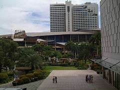

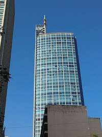
Makati Avenue is a retail and entertainment hub of Makati. At its south end, the avenue bisects the Ayala Center, separating Glorietta, Landmark department store and The Link shopping mall from the more upscale Greenbelt shopping center. This section of the avenue also hosts the Ayala Museum, Greenbelt Chapel, as well as several luxury hotels such as the Makati Shangri-La, Manila, Fairmont Hotel Manila, Raffles Hotel Manila, and New World Makati Hotel. The stretch from Ayala Avenue to Gil Puyat Avenue is the site of the Ayala Triangle Gardens, which houses the Old Nielson Tower and the future Mandarin Oriental Manila. This section of the avenue also hosts The Peninsula Manila, Zuellig Building, Pacific Star Building, as well as several other office buildings.
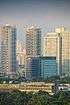
North of Gil Puyat are more hotels and commercial establishments, particularly near the intersection with Kalayaan Avenue. The A. Venue Mall and Century City Mall are located in this area, as well as Gramercy Residences, Trump Tower Manila, Berjaya Makati Hotel, I'M Hotel Makati, St. Giles Hotel and Best Western Antel. The Sts. Peter and Paul Parish Church and Saint Paul College of Makati can be accessed by turning east onto Valdez Street before reaching J.P. Rizal Avenue and the Makati–Mandaluyong Bridge.
References
- "Ayala Now April–June 2015" (PDF). Ayala Corporation. Retrieved 27 October 2015.
- History of FHL published by Filipinas Heritage Library; accessed 8 September 2013.
- Flesh trade thrives in Makati published by Trafficking.org.ph; accessed 8 September 2013.
- Makati now a sin city published by Inquirer.net; accessed 8 September 2013.
- Century City Mall to set the stage for a shopping district North of Makati published by Manila Standard Today; accessed 8 September 2013.
- "NCR". Department of Public Works and Highways. Retrieved 29 May 2020.
| Towers |
|  | ||||
|---|---|---|---|---|---|---|
| Ayala Center | ||||||
| Other landmarks | ||||||
| Education | ||||||
| Transportation |
| |||||
Italics denote buildings under construction or planned. | ||||||
| Century City |
|  |
|---|---|---|
| Picar Place | ||
| Rockwell Center | ||
| Other landmarks | ||
| Education |
| |
| Transportation |
| |
Italics denote buildings under construction or planned. | ||