Quezon Avenue
Manuel L. Quezon Avenue, more often called as Quezon Avenue, or simply Quezon Ave (pronounced: Ke-zon-Av), is a 7.1-kilometer (4.4 mi), six-to-fourteen lane, major thoroughfare in Metro Manila named after President Manuel Luis Quezon, the second president of the Philippines. The avenue starts at the Quezon Memorial Circle and runs through to the Welcome Rotonda at the boundary of Quezon City and Manila.
| |
|---|---|
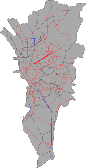 Map of Quezon Avenue in Metro Manila | |
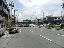
 View northward from the Roosevelt Avenue pedestrian overpass | |
| Route information | |
| Length | 7.1 km (4.4 mi) |
| Component highways |
|
| Major junctions | |
| Northeast end | |
| |
| Southwest end | Welcome Rotonda in Quezon City |
| Location | |
| Major cities | Quezon City |
| Highway system | |
| |
.svg.png)
It is one of the most comfortable roads in Quezon City, lined with palm trees on its center island. Many government and commercial buildings line the road. At its north end, the Triangle Park, one of Quezon City's Central Business District, is the third most important industrial center in the city. At its south end, it connects Quezon City to the Philippine's capital – Manila connecting with Eulogio Rodriguez Sr. Avenue. It is a regular route for vehicles from Quezon City leading to Manila, as the highway provide access to the Quiapo district of Manila and the University Belt.
History
The road, much like Commonwealth Avenue, was built as part of the road building projects of Ferdinand Marcos. It was named Don Mariano Marcos Avenue to honor Mariano Marcos, the President's father. The road was renamed Quezon Avenue after former president Manuel Quezon following the 1986 People Power Revolution with the ascension of Corazon Aquino as president. It originally starts at EDSA, but the portion between the Elliptical Road and EDSA, which used to be named Commonwealth Avenue extension, became a part of the road. With the passing of the 1987 constitution, Quezon City had four legislative districts. The west of the Quezon Avenue were constituted into the first district and the fourth district situated east of the road.
U-turn slots
In 2003, after the perceived effectiveness in EDSA, Commonwealth Avenue and Marcos Highway, the Metropolitan Manila Development Authority (MMDA) implemented the "clearway scheme"; this has prohibited crossings and left turns on the avenue. In lieu of left turns, the MMDA has constructed U-turn slots 100 to 200 meters away from the intersections to allow vehicles to reach their destination.[1]
Quezon Avenue–Araneta Avenue underpass
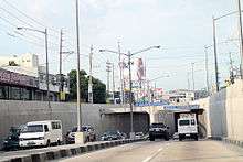
In June 2011, a 440-meter (1,440 ft) four-lane underpass was started along the Gregorio Araneta Avenue Intersection. The construction was slated to take up to 15 months.[2] On September 2012, President Benigno Aquino III opened the underpass to the public. The project cost 452 million pesos, or below the 534 million peso-budget allocated for it.[3]
Motorcycle lanes
In 2012, the MMDA instituted motorcycle lanes in the avenue. The lanes are painted blue, and are meant for the exclusive use of motorcycle riders. This comes after the successful use of the "blue lanes" on EDSA, Commonwealth Avenue and Diosdado Macapagal Boulevard, although the blue lane on EDSA is not exclusive to motorcycles.[4]
Intersections
.jpg)
The entire route is located in Quezon City. Intersections are numbered by kilometer post, with Rizal Park in Manila designated as kilometer zero.
| km | mi | Destinations | Notes | ||
|---|---|---|---|---|---|
| 6.529 | 4.057 | Northern terminus | |||
| Northeastern end of Quezon Avenue–EDSA Underpass | |||||
| BIR Road / Agham Road | Accessible from service roads only | ||||
| Traffic light intersection | |||||
| Sergeant Esguerra Avenue | Accessible from service roads only. Northbound segment provides access to Timog Avenue. | ||||
| Southwestern end of Quezon Avenue–EDSA Underpass | |||||
| Scout Albano Street | Northbound only | ||||
| Examiner Street | Southbound only. Access to West Avenue. | ||||
| Scout Borromeo Street | Northbound only | ||||
| West 4th Street | Southbound only | ||||
| Scout Santiago Street | Northbound only | ||||
| Ligaya Street | Southbound only | ||||
| Traffic light intersection | |||||
| Jose Abad Santos Street | Southbound only | ||||
| Scout Reyes Street | Northbound only | ||||
| Scout Magbanua Street | Northbound only | ||||
| Don Alejandro Roces Avenue | Southbound access by U-turn only. Access to Tomas Morato Avenue and Kamuning Road. | ||||
| Roosevelt Avenue | Northbound access by U-turn only. Access to San Francisco del Monte and Project 7. | ||||
| Dr. Garcia Street | Northbound only | ||||
| General Lim Street | Southbound only | ||||
| Scout Chuatoco Street | Northbound only | ||||
| 7.200 | 4.474 | Quezon Avenue Bridge over San Juan River | |||
| Northeastern end of G. Araneta Underpass | |||||
| Traffic light intersection. No left turn allowed from both directions. | |||||
| Santo Domingo Avenue | Access from southbound service road only | ||||
| Southwestern end of G. Araneta Underpass | |||||
| Tuayan Street | Access from northbound service road only | ||||
| Biak na Bato Street | Southbound only | ||||
| Victory Avenue | Northbound only | ||||
| Banawe Avenue | Traffic light intersection | ||||
| Cordillera Street | Opposite segments accessible via U-turn slots | ||||
| D. Tuazon Avenue | Traffic light intersection | ||||
| Speaker Perez Street / Apo Street / Kanlaon Street | Southbound only | ||||
| Kitanlad Street | Northbound only | ||||
| 11.547 | 7.175 | Welcome Rotonda. Continues to Manila as España Boulevard. Access to New Manila and Cubao districts via Eulogio Rodriguez Sr. Avenue, La Loma and Sta. Mesa Heights districts via Mayon Avenue. | |||
1.000 mi = 1.609 km; 1.000 km = 0.621 mi
| |||||
Landmarks
- Welcome Rotonda
- Quezon Memorial Circle
- Ninoy Aquino Parks & Wildlife Center
- Lung Center of the Philippines
- Manila Seedling Bank (now permanently closed)
- Delta Theatre (Dela Merced Building, soon-to-be-converted by DMCI into a mixed-used residential project)[5]
- Santo Domingo Church
- Bantayog ng mga Bayani Center
Commercial Structures
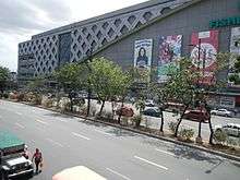
- Fisher Mall
- Eton Centris
- Crossings Department Store and Supermarket
- Sun Residences
Future
There is a planned underground/elevated expressway to be built over Quezon Avenue and Commonwealth Avenue, the R-7 Expressway, a 16.1 kilometres (10.0 mi) 4-lane tollroad. Construction might begin in 2016–2018.[6]
Another proposed structure that may be built along Quezon Avenue is the former MRT-9, or the PNR East-West Line, that will provide railway services and connect it to the currently-under-construction MRT-7.
See also
- Commonwealth Avenue, eastern extension of Quezon Avenue starting from the Quezon Memorial Circle.
- Espana Boulevard, western extension of Quezon Avenue starting from Mabuhay Rotonda.
- Epifanio de los Santos Avenue (C-4)
- Major Roads in Metro Manila
References
- "All set for Quezon Avenue clearway". Philippine Star. 2003-08-14. Retrieved 2013-04-14.
- Kwok, Abigail (2011-06-20). "Underpass construction on Quezon, Araneta Avenues start". Interaksyon.com. Retrieved 2013-04-14.
- "P452-M Quezon-Araneta underpass opens today". ABS-CBNnews.com. 2012-09-28. Retrieved 2013-04-14.
- Melican, Nathaniel (2012-02-14). "MMDA sees safer EDSA with motorcycle lanes". Philippine Daily Inquirer. Retrieved 2013-04-14.
- "DMCI Homes buys Delta building in QC". The Standard. Retrieved 18 December 2015.
- "Archived copy". Archived from the original on June 16, 2012. Retrieved June 1, 2012.CS1 maint: archived copy as title (link)
| Wikimedia Commons has media related to Quezon Avenue. |
Triangle Park | |||||
|---|---|---|---|---|---|
Quezon City Central Business District | |||||
| Towers |
|  | |||
| Shopping centers | |||||
| Other landmarks |
| ||||
| Education | |||||
| Transportation |
| ||||
Italics denote buildings under construction or planned. | |||||