Bonny Serrano Avenue
Colonel Bonny Serrano Avenue (also spelled Boni Serrano Avenue), a.k.a. Santolan Road is a major east-west thoroughfare in the Eastern Manila District of Metro Manila, Philippines, running between San Juan and Quezon City. It forms the northern limit of San Juan and the southern limit of Quezon City's New Manila and Cubao districts and links the Philippine National Police headquarters in Camp Crame with the Armed Forces of the Philippines headquarters in Camp Aguinaldo. The avenue, formerly called and still referred as Santolan Road, runs from the border between Greenhills, San Juan and Horseshoe Village, Quezon City in the west to the villages of Libis and Blue Ridge by Quezon City's border with Marikina in the east. It was named after the decorated Korean War hero, Venancio "Bonny" Serrano.[2]
| |
|---|---|
| Santolan Road | |
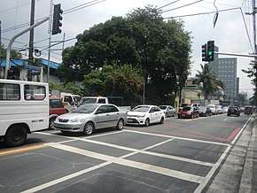 Bonny Serrano Avenue looking east from 8th Avenue in Cubao | |
| Route information | |
| Maintained by Department of Public Works and Highways and Metro Manila Development Authority | |
| Length | 2.2 km (1.4 mi) |
| Component highways | |
| Major junctions | |
| West end | P. Guevarra Street and Pinaglabanan Street in Corazon De Jesus, San Juan |
| |
| East end | Diosdado Macapagal Bridge / C-5 Access Road in Marikina City |
| Location | |
| Provinces | Metro Manila |
| Major cities | Quezon City and San Juan |
| Highway system | |
| |
.svg.png)
.svg.png)
History
Bonny Serrano Avenue was formerly called the Carretera de Santolan (Santolan Road) which ran from the Santolan pumping station on the Mariquina River to El Deposito water reservoir in San Juan del Monte, the main source of water for Manila residents during the Spanish colonial period. It was built around 1901 during the early years of the American colonial period at a cost of $150 (150 pesos).[3] In 1935, the road, also known as the San Juan–Santolan Road, became the location of Camp Murphy, home of the United States Army Philippine Department, and eventually the Philippine Commonwealth Army, which was named after then Governor-General Frank Murphy. The military camp eventually became Camp Aguinaldo and Camp Crame when the Philippines gained independence after World War II. The San Juan–Quezon City segment of Santolan Road was then renamed after Colonel Bonny Merioles Serrano in 1970, three months after the war hero's death.[4]
Route description
The four-lane avenue begins as a continuation of Pinaglabanan Street at Pedro Guevarra Street in the Corazon De Jesus area of San Juan. It proceeds due east and runs through the boundary between Quezon City's Bagong Lipunan ng Crame and San Juan's West Crame villages, passing through the San Juan Municipal Cemetery before arriving at the northern side of Camp Crame. East of the Epifanio de los Santos Avenue junction, the avenue runs the northern boundary of Camp Aguinaldo with the villages of Socorro (Cubao), San Roque and Bayanihan, and intersecting with 15th Avenue at Camp Aguinaldo Gate 1. It then intersects with Katipunan Avenue (C-5) via an overpass, passing through Blue Ridge and Saint Ignatius villages before terminating at Eulogio Rodriguez Jr. Avenue in Libis near Camp Atienza where it continues as FVR Road all the way to the Marikina–Infanta Highway in Calumpang, Marikina and Santolan, Pasig. This section of the avenue connecting Katipunan and Eulogio Rodriguez Jr. Avenue is designated as a component of Circumferential Road 5 (C-5 Road).
The Avenue is a problematic major road that has frequent traffic jams.
Intersections
| Province | City/Municipality | km | mi | Destinations | Notes |
|---|---|---|---|---|---|
| San Juan | Pinaglabanan Street, P. Guevarra Street | Western terminus. Continues westward as Pinaglabanan Street. Access to Sta. Mesa, Mandaluyong & New Manila districts via N. Domingo Street. Only Santolan Road is used as name for this segment. | |||
| Jose Abad Santos Street | Exit to Santolan Road only. | ||||
| M. Paterno Street, Pasadena Drive | Unsignaled intersection. | ||||
| San Juan—Quezon City boundary | Don Gonzalo Street | Gated community road. | |||
| Traffic light intersection. Access to | |||||
| Main Horseshoe Drive | One-way from Horseshoe Drive. | ||||
| C. Benitez Street | Access to Cubao via P. Tuazon & N. Domingo. | ||||
| Sunrise Drive | Loops back to road. | ||||
| Tyler Street | North Greenhills community road. | ||||
| 5th West Crame | |||||
| 4th West Crame | |||||
| 3rd West Crame | |||||
| 2nd West Crame | |||||
| 1st West Crame | |||||
| Quezon City | General Castañeda Street | Camp Crame Gate 3. | |||
| 1st Street | One-way exit to Bonny Serrano Avenue. Only Col. Bonny Serrano Avenue is the name used beginning this segment of the road. | ||||
| 2nd Street | One-way exit from Bonny Serrano Avenue. | ||||
| 3rd Street | One-way exit to Bonny Serrano Avenue. | ||||
| Gen. J. Delos Reyes Street | Camp Crame Gate 2. | ||||
| 4th Avenue | One-way, westbound only exit from Bonny Serrano Avenue. | ||||
| Traffic light intersection. Northbound goes to Cubao & Balintawak, southbound goes to Mandaluyong & Makati. Beginning of N185 designation. | |||||
| 5th Avenue | |||||
| 6th Avenue | One-way exit to Bonny Serrano Avenue. | ||||
| 7th Avenue | One-way exit to Bonny Serrano Avenue. | ||||
| 8th Avenue | One-way exit to Bonny Serrano Avenue. | ||||
| 9th Avenue | One-way exit from Bonny Serrano Avenue. Access to Araneta Center. | ||||
| 10th Avenue | |||||
| 11th Avenue | |||||
| 12th Avenue | One-way exit to Bonny Serrano Avenue. | ||||
| 13th Avenue | One-way exit from Bonny Serrano Avenue. Access to Araneta Center. | ||||
| 14th Avenue | One-way exit to Bonny Serrano Avenue. | ||||
| 15th Avenue/Delos Reyes Avenue | Traffic light intersection. No entry to 15th Avenue. Camp Aguinaldo Gate 1. | ||||
| 5th Camarilla | |||||
| 6th Camarilla | |||||
| 18th Avenue | |||||
| 19th Avenue | |||||
| 20th Avenue | Traffic light intersection. Access to Projects 2, 3 & 4. | ||||
| Arturo Enrile Avenue | Camp Aguinaldo Gate 6. | ||||
| Pedro Martinez Street (P. Pelaez St. Extension) | Access to pedestrians only. | ||||
| Traffic light intersection. Northbound goes to Commonwealth & Tandang Sora Avenues, Cubao & Marikina via Aurora Boulevard; southbound goes to Pasig, White Plains & Greenmeadows. Route changes from N185 to N11. | |||||
| Highland Drive | Westbound service road only. | ||||
| Riviera Street | Saint Ignatius Village community road. No entry allowed. | ||||
| No left turn from E. Rodriguez Jr. Avenue. Access to Pasig, Taguig & Makati. End of N11 designation. | |||||
| Riverview Drive | No entry from eastbound side. | ||||
| Mejia Street | No entry from westbound side. | ||||
| Quezon City—Marikina City boundary | Diosdado Macapagal Bridge | Eastern terminus. Service road continues along Marikina Riverbanks as C-5 Access Road. Bridge access to SM Marikina; Pasig, Cainta, Antipolo & Tanay via | |||
1.000 mi = 1.609 km; 1.000 km = 0.621 mi
| |||||
References
- "NCR". Department of Public Works and Highways. Retrieved May 25, 2020.
- "Bikol awardees give back to their birthplaces". Philippine Daily Inquirer. Retrieved 16 May 2015.
- "Public laws and resolutions passed by the United States Philippine Commission, during the quarter". United States Philippine Commission. Retrieved 16 May 2015.
- "Introducing Mrs. Bonny Serrano". Philippine Daily Inquirer. Retrieved 16 May 2015.