West Avenue, Quezon City
West Avenue is a major road located in Quezon City within the Diliman area of northeastern Metro Manila, Philippines. It runs north–south through the western edge of the barangay of West Triangle. The street is located in Quezon City's commercial-residential area, known for its restaurants, car shops, schools, and villages.[1] It is also home to the old Delta theater located on the avenue's junction with Quezon Avenue. The avenue is a component of National Route 171 (N171) of the Philippine highway network.
| ||||
|---|---|---|---|---|
 | ||||
| Route information | ||||
| Maintained by Department of Public Works and Highways | ||||
| Length | 2.056 km (1.278 mi) | |||
| Component highways | ||||
| Major junctions | ||||
| North end | ||||
| South end | ||||
| Location | ||||
| Major cities | Quezon City | |||
| Highway system | ||||
| ||||
.svg.png)

History
The avenue forms the western boundary of the formerly proposed 400-hectare (990-acre) Diliman Quadrangle within the former Diliman Estate also known as Hacienda de Tuason, purchased by the Philippine Commonwealth government in 1939 as the new capital to replace Manila.[2] It was originally planned as the new city's Central Park housing the new national government buildings (the new Presidential palace, Capitol Building, and Supreme Court complex) within the 25-hectare (62-acre) elliptical site now known as the Quezon Memorial Circle. The quadrangle is bordered on the north by North Avenue, on the east by East Avenue, on the south by Timog (South) Avenue, and on the west by West Avenue. Designed by American city planner William E. Parsons and Harry Frost, in collaboration with engineer AD Williams and architects Juan Arellano and Louis Croft, the site was also to contain the 15-hectare (37-acre) national exposition grounds opposite the corner of North Avenue and EDSA (now occupied by SM City North Edsa shopping mall).[2] The Diliman Quadrangle had been largely undeveloped for decades due to lack of funding. After several revisions, the government planners moved the city center to Novaliches due to its higher elevation.[3] By 1976, the country's capital had been transferred back to Manila with only the Quezon Memorial built in the former capital site.
Route description
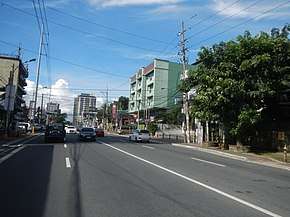
West Avenue is a four-lane road located at the heart of Quezon City's residential-commercial district. It begins at its junction with EDSA west of North Avenue by the border with the central Diliman barangays of Bungad and Phil-Am. It heads south from this junction to cross Baler Street and Examiner Street towards the intersection with Del Monte Avenue. The avenue terminates at the junction with Quezon Avenue, west of Timog Avenue, in Barangays West Triangle and Santa Cruz.
Intersections
| Province | City/Municipality | km | mi | Destinations | Notes |
|---|---|---|---|---|---|
| Quezon City | Traffic light intersection. Southern terminus. Access to the city of Manila and Quezon Memorial Circle via Quezon Avenue, South Triangle district via Timog Avenue. | ||||
| Colonel Martinez Street | |||||
| Zamboanga Street | |||||
| Times Street | |||||
| Ligaya Street | |||||
| Bulletin Street | |||||
| Masbate Street | |||||
| Del Monte Avenue, Liwayway Street | Traffic light intersection. Westbound goes to San Francisco Del Monte district. | ||||
| Mabuhay Street | |||||
| Cavite Street | |||||
| Examiner Street | Access to Quezon Avenue. | ||||
| Catanduanes Street | |||||
| Baler Street | Traffic light intersection. Westbound access to Roosevelt Avenue. | ||||
| West Lawin Street | |||||
| Bulacan Street | |||||
| Northern terminus. Access from EDSA Southbound lane only. Access to North Avenue via U-Turn slot. | |||||
| 1.000 mi = 1.609 km; 1.000 km = 0.621 mi | |||||
References
- "Business brings more fun in Quezon City". Quezon City Business. Retrieved 16 May 2015.
- "The 1946 Quezon City world's fair". The Philippine Star. Retrieved 16 May 2015.
- "25 things you didn't know about Quezon City". The Philippine Star. Retrieved 16 May 2015.