Sikar district
Sikar district is a district of the Indian state Rajasthan in northern India. The city of Sikar is the administrative headquarters of the district. Sikar, Shrimadhopur, Neem Ka Thana, and Fatehpur Shekahwati are the largest cities and tehsils of the district.
Sikar district | |
|---|---|
District of Rajasthan | |
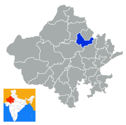 Location of Sikar district in Rajasthan | |
| Coordinates (Sikar): 27.21°N 74.44°E - 28.12°N 75.25°E | |
| Country | India |
| State | Rajasthan |
| Division | Jaipur Division |
| Headquarters | Sikar |
| Tehsils |
|
| Government | |
| • Lok Sabha constituencies | Sikar[1] |
| • Vidhan Sabha constituencies |
|
| Area | |
| • Total | 7,742.44 km2 (2,989.37 sq mi) |
| Population (2011) | |
| • Total | 2,677,333[3] |
| • Urban | 633,300 |
| Demographics | |
| • Literacy | 72.98 |
| • Sex ratio | 944 |
| Time zone | UTC+05:30 (IST) |
| Vehicle registration | RJ 23 |
| Major highways | NH-11, State Highway 8 |
| Average annual precipitation | 459.8 mm |
| Website | sikar |
Cities and towns
Cities
- Sikar
- Shrimadhopur
- Neem ka thana
- Fatehpur
Large towns
Medium towns
- Ajeetgarh, Teh. Shrimadhopur
- Patan, Teh. Neem-Ka-Thana
- Khandela
Small towns
- Mundru, Teh. Shri Madhopur
- Nechhwa, Teh. Laxmangarh
- Kanwat, Teh. Khandela
- Palsana, Teh. Khandela
- Dabla, Teh. Neem-Ka-Thana
- Sihot chhoti
- Dhod
Location
The district is located in the north-eastern part of the state of Rajasthan. It is bounded on the north by Jhunjhunu district, in the north-west by Churu district, in the south-west by Nagaur district and in the south-east by Jaipur district. It also touches Mahendragarh district of Haryana on its north-east corner.
The district has an area of 7742.44 km² and a population of 26,77,737 (2011 census). Sikar, Churu district and Jhunjhunu district's comprise the Shekhawati region of Rajasthan. The old name of Sikar was "Veer Bhan Ka Bas".
| Longitude | 74.44 degree to 75.25 degree |
| Latitude | East 27.21 degree to 28.12 degree North |
Demographics
| Historical population | ||
|---|---|---|
| Year | Pop. | ±% p.a. |
| 1901 | 466,624 | — |
| 1911 | 469,440 | +0.06% |
| 1921 | 462,595 | −0.15% |
| 1931 | 521,159 | +1.20% |
| 1941 | 614,584 | +1.66% |
| 1951 | 676,318 | +0.96% |
| 1961 | 820,286 | +1.95% |
| 1971 | 1,042,648 | +2.43% |
| 1981 | 1,377,245 | +2.82% |
| 1991 | 1,842,914 | +2.96% |
| 2001 | 2,287,788 | +2.19% |
| 2011 | 2,677,333 | +1.58% |
| source:[4] | ||
According to the 2011 census Sikar district has a population of 2,677,333,[5] roughly equal to the nation of Kuwait[6] or the US state of Nevada.[7] This gives it a ranking of 150th in India (out of a total of 640).[5] The district has a population density of 346 inhabitants per square kilometre (900/sq mi).[5] Its population growth rate over the decade 2001-2011 was 17.04%.[5]
Sikar has a sex ratio of 944 females for every 1000 males,[5] and a literacy rate of 72.98%.[5]
At the time of the 2011 Census of India, 97.96% of the population in the district spoke Hindi and 1.94% Urdu as their first language.[8]
Climate
The district has a hot summer, scanty rainfall, a chilly winter season and a general dryness of the air, except in the brief monsoon season. The maximum and minimum temperatures are 47 to 48 and 1 to 0 degrees Celsius, respectively. The average temperature around the year is about 35 degrees Celsius. The normal rainfall, mostly received from the southwest monsoon, is 459.8 mm.
Education
Sikar district has become a hub for education in Rajasthan state. Pandit Deendayal Upadhyaya Shekhawati University situated in the Sikar giving student opportunity to complete their dream of higher education in many field. Along with government colleges providing arts, sciences, and commerce education, private educational institutes play a good role in imparting education in the district. Mody Institute of Technology and Science, which is in the Lakshmangarh town of the district imparts girls' education. Other reputed colleges includes Sobhasaria Engineering College.[9] There is one Government Polytechnic College in Sikar district. District is also an emerging hub of coaching IIT-JEE and NEET.Here some famous institutes provide coaching for engineering and medical exams. Some institutes are Allen, Matrix, Kautilya, GCI, CLC, Impulse, PCP, Samarpan, Swabhiman.[10] Sikar is the smallest city which has IIT JEE Advance centre. Youth men (below 35) provide a major role in Indian defense services compared to other districts of Rajasthan.
Administration
Sub divisions, tehsils, sub tehsils, panchyat samitis and villages
| Total sub divisions | 7
(Sikar, Fatehpur, Laxmangarh, Dantaramgarh, Sri Madhopur, Neem Ka Thana, Khandela) |
| Total tehsils | 7 (Sikar, Fatehpur, Laxmangarh, Dantaramgarh, Sri Madhopur, Neem Ka Thana, Khandela) |
| Total sub tehsils | 6 (Patan, Palsana, Ajitgarh, Necchawa, Losal, Ramgarh Shekhawati) |
| Blocks (Panchyat Samitis) | 9 (Dhod, Piprali, Fatehpur, Laxmangarh, Dantaramgarh, Sri Madhopur, Khandela, Neem Ka Thana,Patan) |
| Total villages | 1183 |
Local bodies
| Total Gram Panchayat | 342 |
| Total Nagar-Palika | 8 |
| Total Nagar-Parishad | 1 |
Police
| Total Police-Thana | 23 |
| Police-Chowki | 27 |
| Jails (prisons) | 333 |
References
- "Parliamentary Constituencies of Rajasthan" (PDF). 164.100.9.199/home.html. 2012. Archived from the original (PDF) on 16 June 2013. Retrieved 28 February 2012.
- "Assembly Constituencies of Sikar district" (PDF). gisserver1.nic.in/. 2012. Retrieved 28 February 2012.
- "Name Census 2011, Rajasthan data" (PDF). censusindia.gov.in. 2012. Retrieved 28 February 2012.
- Decadal Variation In Population Since 1901
- "District Census 2011" (PDF). Census2011.co.in. 2011. Retrieved 30 September 2011.
- US Directorate of Intelligence. "Country Comparison:Population". Retrieved 1 October 2011.
Kuwait 2,595,62
- "2010 Resident Population Data". U. S. Census Bureau. Retrieved 30 September 2011.
Nevada 2,700,551
- 2011 Census of India, Population By Mother Tongue
- Sobhasaria Engineering College Website
- "Swabhiman". Swabhiman NEET & JEE Academy. Retrieved 14 January 2020.
External links
| Wikimedia Commons has media related to Sikar district. |
Places adjacent to Sikar district | ||||||||||
|---|---|---|---|---|---|---|---|---|---|---|
| ||||||||||
| Outline |
|  | |||||||||||||
|---|---|---|---|---|---|---|---|---|---|---|---|---|---|---|---|
| Governance |
| ||||||||||||||
| Divisions and districts |
| ||||||||||||||
| Major cities | |||||||||||||||
| Related templates |
| ||||||||||||||