Alwar district
Alwar is a district in the state of Rajasthan in northern India, whose district headquarters is Alwar city. The district covers 8,380 km2. It is bound on the north by Rewari district of Haryana, on the east by Bharatpur district of Rajasthan and Nuh district of Haryana, on the south by Dausa district, and on the west by Jaipur district.
Alwar district | |
|---|---|
District of Rajasthan | |
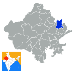 Location of Alwar district in Rajasthan | |
| Coordinates (Alwar): 27°34′12″N 76°36′00″E | |
| Country | India |
| State | Rajasthan |
| Headquarters | Alwar |
| Tehsils | Alwar, Bansur, Behror, Govindgarh, Kathumar, Kishangarh Bas, Kotkasim, Laxmangarh, Mundawar, Rajgarh, Ramgarh, Thanagazi, Tijara, Neemrana, Reni, Malakhera |
| Population (2011[1]) | |
| • Total | 3,674,179 [3rd in RJ] |
| Time zone | UTC+05:30 (IST) |
| Website | alwar |
As of 2011 it is the third most populous district of Rajasthan (out of 33) after Jaipur and Jodhpur.[2]

Administration
Alwar district has 16 tehsils:[3] Alwar, Bansur, Behror, Govindgarh, Kathumar, Kishangarh Bas, Kotkasim, Laxmangarh, Mundawar, Rajgarh, Ramgarh, Thanagazi, Tijara, Neemrana, Reni, Malakhera.
Industry
The district has industrial estates such as Alwar, Bhiwadi, Shahjahanpur, Neemrana, Behror where companies such as G. S. Pharmbutor, Ashok Leyland, Pepsi, Parryware, Kajaria Ceramics, and Honda Motors have manufacturing plants.
Agriculture
Alwar has an important place in Agriculture production in Rajasthan. The total geographical area of the district is 7,83,281 hectares which is about 2.5 percent of the State. In 2010–2011 the net cultivated area is 5,07,171 hectares from which about 83 percent area viz. – 4,51,546 is irrigated and the remaining 17 percent area viz. – 82,903 is unirrigated. Double cropped area is nearly 2,52,000 hectares of which 32,230 (12%) is irrigated and remaining 2,19,819 (88%) is unirrigated. Thus, the total cropped area of the district is 8,12,873 hectares. In Kharif season bajra, maize, Jowar, Kharif pulses, Arhar, sesamum, cotton, guar etc. are sown in about 3,29,088 hectares (42%) and in Rabi season wheat, barley, gram, mustard, taramira, rabi pulses are sown in about 4,52,527 hectares (58%). The main source of irrigation are wells and Tube Wells. By 26064 Tube Wells, about 192861-hectare area is being irrigated and by 57196 Wells about 265169 hectares area is irrigated. By other sources like canals, tanks about 404 hectares area is irrigated. About 35470 electric motors and 66502 Diesel pump sets are being used for Irrigation purposes. The normal rainfall for the district is 657.3 mm. The average rainfall in the last ten years in the district is 724 mm. The rainfall distribution in the district is uneven and scattered which resulted in some times flood problems and some time draught position which affect the Agriculture production as well as cropping pattern in Kharif & Rabi season. Thus, the Agriculture in the district by and large depends on rainfall distribution. The average rainfall in 2016 up to September is 217 mm.
Places of interest

Bala Qilla (Alwar fort) situated in the Aravali Hills is one of the best forts present in Rajasthan. It is said that it has never been invaded or conquered by any king. Just behind it is the Nikumbh Mahal. There are many small palaces in the city and an old museum with a collection of paintings, armours, and old weapons.
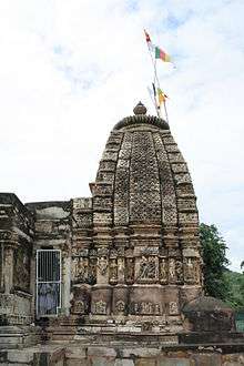
Neelkanth temple is an old temple dedicated to Lord Shiva, built between the 6th to the 9th century.
Bhangarh Haunted Fort
Banghar Fort is a haunted fort and the Archaeological Survey of India has put up a board on the fort gate that it is prohibited for tourists to stay inside the fort area after sunset and before sunrise. This fort has become a major tourist attraction.[4]
This Royal Rao Haveli (300 years old), Nizam Nagar (Laxmangarh) is only 25 km from Kesroli fort, Agara-Delhi Road. Ruled & established by H.H.Rao Bhero Singh (Riyastdar), who was the Relative of H.H Yashwant Singh, the king Of Alwar.
Sariska Tiger Reserve is also located in the district, and Arvari River flows through this district. Hill Fort Kesroli, currently a heritage hotel, is also nearby at Kesroli.
Demographics
| Historical population | ||
|---|---|---|
| Year | Pop. | ±% p.a. |
| 1901 | 851,285 | — |
| 1911 | 811,689 | −0.48% |
| 1921 | 718,788 | −1.21% |
| 1931 | 768,324 | +0.67% |
| 1941 | 843,576 | +0.94% |
| 1951 | 861,896 | +0.22% |
| 1961 | 1,089,561 | +2.37% |
| 1971 | 1,390,724 | +2.47% |
| 1981 | 1,755,217 | +2.35% |
| 1991 | 2,295,648 | +2.72% |
| 2001 | 2,991,552 | +2.68% |
| 2011 | 3,674,179 | +2.08% |
| source:[5] | ||
According to the 2011 census Alwar district has a population of 3,674,179,[2] roughly equal to the nation of Liberia[6] or the US state of Oklahoma.[7] This gives it a ranking of 77th in India (out of a total of 640).[2] The district has a population density of 438 inhabitants per square kilometre (1,130/sq mi) .[2] Its population growth rate over the decade 2001-2011 was 22.7%.[2] Alwar has a sex ratio of 894 females for every 1000 males,[2] and a literacy rate of 71.68%.[2]
At the time of the 2011 Census of India, 96.08% of the population in the district spoke Hindi, 2.00% Punjabi and 1.02% Bhili as their first language.[8]
Transport
National Highway NH8 (Delhi-Jaipur-Ajmer-Ahmedabad-Bombay highway) passes through the Behror district. Alwar district is reached from New Delhi by NH8 or by Gurgaon-Sohna-Alwar highway that is being widened to six lanes.
Delhi-Jaipur railway line also passes through the district. Alwar city railway station is one of the railway stations in the district.
Rivers in Alwar
Alwar district does not have any perennial river. It has seasonal streams that carry water during rains. They are the Sahibi River at Sodawas and the Arvari River. Several small check dams have been built on these streams to collect rainwater.
References
- https://www.citypopulation.de/php/india-rajasthan.php?adm2id=0806
- "District Census 2011". Census2011.co.in. 2011. Retrieved 30 September 2011.
- "Welcome to Alwar, The Gateway of Rajastan > Administrative Setup Of Alwar District". Alwar.nic.in. Archived from the original on 6 March 2013. Retrieved 7 March 2013.
- http://articles.timesofindia.indiatimes.com/2013-07-15/travel/40589314_1_ghosts-fort-area-alwar
- Decadal Variation In Population Since 1901
- US Directorate of Intelligence. "Country Comparison:Population". Retrieved 1 October 2011.
Liberia 3,786,764 July 2011 est.
- "2010 Resident Population Data". U. S. Census Bureau. Archived from the original on 19 October 2013. Retrieved 30 September 2011.
Oklahoma 3,751,351
- 2011 Census of India, Population By Mother Tongue
External links
| Wikimedia Commons has media related to Alwar district. |
Places adjacent to Alwar district | |
|---|---|
| Outline |
|  | |||||||||||||
|---|---|---|---|---|---|---|---|---|---|---|---|---|---|---|---|
| Governance |
| ||||||||||||||
| Divisions and districts |
| ||||||||||||||
| Major cities | |||||||||||||||
| Related templates |
| ||||||||||||||