Jaisalmer district
Jaisalmer District, is a district of Rajasthan state in western India. The city of Jaisalmer is the administrative headquarters of the district.it is appx 289 km from the Jodhpur city and 559 km from the Jaipur city.
Jaisalmer district | |
|---|---|
District of Rajasthan | |
.jpg) | |
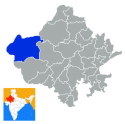 Location of Jaisalmer district in Rajasthan | |
| Country | India |
| State | Rajasthan |
| Population (2011) | |
| • Total | 669,919 |
| Time zone | UTC+05:30 (IST) |
As of 2011 it is the least populous district of Rajasthan (out of 33).[1]
Geography
It is the largest district of Rajasthan and third largest in the country in area.
Jaisalmer District lies in the Thar Desert, which straddles the border of India and Pakistan. It is bounded on the northeast by Bikaner District, on the east by Jodhpur District, on the south by Barmer District, and on the west and north by Pakistan.
The district is located within a rectangle lying between 26°.4’ –28°.23' North parallel and 69°.20'-72°.42' east meridians.
The length of international border attached to the district is 464 km.
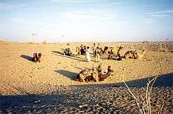
Jaisalmer is almost entirely a sandy waste, forming a part of the great Indian desert. The general aspect of the area is that of an interminable sea of sandhills, of all shapes and sizes, some rising to a height of 150 ft. Those in the west are covered with log bushes, those in the east with tufts of long grass. Water is scarce, and generally brackish; the average depth of the wells is said to be about 250 ft. There are no perennial streams, and only one small river, the Kakni, which, after flowing a distance of 28 m., spreads over a large surface of flat ground, and forms a lake orjhil called the Bhuj-Jhil. The climate is dry and healthy. Throughout Jaisalmer only raincrops, such as bajra, joar, motif, til, etc., are grown; spring crops of wheat, barley, etc., are very rare. Owing to the scant rainfall, irrigation is almost unknown.
Climate
| Climate data for Jaisalmer | |||||||||||||
|---|---|---|---|---|---|---|---|---|---|---|---|---|---|
| Month | Jan | Feb | Mar | Apr | May | Jun | Jul | Aug | Sep | Oct | Nov | Dec | Year |
| Average high °C (°F) | 23.7 (74.7) |
27.2 (81.0) |
32.8 (91.0) |
38.4 (101.1) |
47.7 (117.9) |
48.0 (118.4) |
42.8 (109.0) |
36.0 (96.8) |
36.5 (97.7) |
36.1 (97.0) |
31.1 (88.0) |
25.4 (77.7) |
35.5 (95.9) |
| Average low °C (°F) | 7.9 (46.2) |
10.9 (51.6) |
16.8 (62.2) |
22.2 (72.0) |
25.7 (78.3) |
27.1 (80.8) |
26.5 (79.7) |
25.4 (77.7) |
24.3 (75.7) |
20.5 (68.9) |
13.8 (56.8) |
8.9 (48.0) |
19.2 (66.5) |
| Average precipitation mm (inches) | 1.3 (0.05) |
4.0 (0.16) |
3.2 (0.13) |
18.1 (0.71) |
9.2 (0.36) |
16.1 (0.63) |
56.1 (2.21) |
79.0 (3.11) |
16.2 (0.64) |
2.5 (0.10) |
1.3 (0.05) |
2.5 (0.10) |
209.5 (8.25) |
| Average precipitation days (≥ 0.1 mm) | 0.6 | 1.0 | 0.9 | 0.4 | 0.8 | 1.1 | 3.9 | 3.9 | 2.1 | 0.4 | 1.1 | 0.5 | 16.7 |
| Source: WMO | |||||||||||||
Economy
In 2006 the Ministry of Panchayati Raj named Jaisalmer one of the country's 250 most backward districts (out of a total of 640).[2] It is one of the twelve districts in Rajasthan currently receiving funds from the Backward Regions Grant Fund Programme (BRGF).[2]
Demographics
| Historical population | ||
|---|---|---|
| Year | Pop. | ±% p.a. |
| 1901 | 75,551 | — |
| 1911 | 87,162 | +1.44% |
| 1921 | 69,224 | −2.28% |
| 1931 | 78,646 | +1.28% |
| 1941 | 96,958 | +2.12% |
| 1951 | 109,658 | +1.24% |
| 1961 | 141,242 | +2.56% |
| 1971 | 167,824 | +1.74% |
| 1981 | 243,082 | +3.77% |
| 1991 | 344,517 | +3.55% |
| 2001 | 508,247 | +3.96% |
| 2011 | 669,919 | +2.80% |
| source:[3] | ||
According to the 2011 census Jaisalmer district has a population of 669,919,[1] roughly equal to the nation of Equatorial Guinea[5] or the US state of North Dakota.[6] This gives it a ranking of 508th in India (out of a total of 640).[1] The district has a population density of 17 inhabitants per square kilometre (44/sq mi).[1] Its population growth rate over the decade 2001-2011 was 32.22%.[1] Jaisalmer has a sex ratio of 849 females for every 1000 males,[1] and a literacy rate of 58.04%.[1]
At the time of the 2011 Census of India, 95.09% of the population in the district spoke Hindi, 2.56% Sindhi, 1.02% Urdu and 0.40% Punjabi as their first language.[7]
Administrative Set-up
Jaisalmer district has Four sub-divisions: Jaisalmer,Pokaran, Bhaniyana and Fatehgarh.there are the Four tehsils of district, name like Jaisalmer,Pokaran, Bhaniyana.
Jaisalmer and Pokaran are the Nagar Palikas, while 744 villages comes under 140 Gram Panchayats. The developmental activities of the district are being looked after by three Panchayat Samities, i.e. Jaisalmer, Sam and Sankra.
Tourism
Jaisalmer is one of the largest foreign tourist attractor districts in the Rajasthan. Per year about 276,887 tourists visit the district, out of which about 100,000 tourist are foreigners. Some of the tourist attractions in the Jaisalmer are:
- Jaisalmer Fort & inside fort-Jain Temples, Royal Palace & two heritage havelis (haveli shreenath, haveli suraj)
- Patwa Havelies.
- Salim Singh’s Haveli.
- Nathmal’s haveli.
- Mandir Palace (Tazia Tower).
- Gadsisar Lake.
- Govt. museum & the folk museum.
- Tanot Mandir
- Longevala
- Pokharan
- Thar desert
- Bada Bagh
- Lodhruva
- Akal Wood Fossil Park
- Ramdevra
- Maru Udyan
- Mohangarh
Every year Maru Mahotsav is being celebrated for the tourists. Ramdevra is also a big attraction for the Baba Ramdevji's pilgrims. Every year on Mahshivratri in Myajlar Khyala math held festival. Shree Alakh puri ki samadhi in jhinjhinyali is big attraction of Udaisinghont Bhati rajput.
See also
References
- "District Census 2011". Census2011.co.in. 2011. Retrieved 30 September 2011.
- Ministry of Panchayati Raj (8 September 2009). "A Note on the Backward Regions Grant Fund Programme" (PDF). National Institute of Rural Development. Archived from the original (PDF) on 5 April 2012. Retrieved 27 September 2011.
- Decadal Variation In Population Since 1901
- "C-1 Population By Religious Community (Rajasthan)". Census India. Retrieved 5 March 2020.
- US Directorate of Intelligence. "Country Comparison:Population". Retrieved 1 October 2011.
Equatorial Guinea 668,225 July 2011 est.
- "2010 Resident Population Data". U. S. Census Bureau. Archived from the original on 19 October 2013. Retrieved 30 September 2011.
North Dakota 672,591
- 2011 Census of India, Population By Mother Tongue
External links
| Wikimedia Commons has media related to Jaisalmer district. |
Places adjacent to Jaisalmer district | ||||||||||
|---|---|---|---|---|---|---|---|---|---|---|
| ||||||||||
| Outline |
|  | |||||||||||||
|---|---|---|---|---|---|---|---|---|---|---|---|---|---|---|---|
| Governance |
| ||||||||||||||
| Divisions and districts |
| ||||||||||||||
| Major cities | |||||||||||||||
| Related templates |
| ||||||||||||||