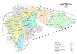
Chittorgarh district
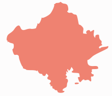
Chittaurgarh district is one of the 33 districts of Rajasthan state in western India.[2] The historic city of Chittaurgarh is the administrative headquarters of the district.[1] The modern district of Chittaurgarh was established on 1 August 1948 by integrating portions of various states: Mewar, Pratabgarh, Tonk, and Jhalawar.[3]
Chittaurgarh district | |
|---|---|
District of Rajasthan | |
 Chittorgarh district | |
| Country | India |
| State | Rajasthan |
| Headquarters | Chittaurgarh |
| Area | |
| • Total | 7,822 km2 (3,020 sq mi) |
| Population (2011) | |
| • Total | 1,544,338[1] |
| Time zone | UTC+05:30 (IST) |
Economy
In 2006 the Ministry of Panchayati Raj named Chittorgarh one of the country's 250 most backward districts (out of a total of 640).[4] It is one of the twelve districts in Rajasthan currently receiving funds from the Backward Regions Grant Fund Programme (BRGF).[4]
Demographics
According to the 2011 census Chittorgarh district has a population of 1,544,338,[5] roughly equal to the nation of Gabon[6] or the US state of Hawaii.[7] This gives it a ranking of 323rd in India (out of a total of 640).[5] The district has a population density of 193 inhabitants per square kilometre (500/sq mi) .[5] Its population growth rate over the decade 2001-2011 was 16.09%.[5] Chittaurgarh has a sex ratio of 970 females for every 1000 males,[5] and a literacy rate of 62.51%.[5]
At the time of the 2011 Census of India, 98.40% of the population in the district spoke Hindi, 0.58% Urdu as their first language.[8]
| Historical population | ||
|---|---|---|
| Year | Pop. | ±% p.a. |
| 1901 | 234,331 | — |
| 1911 | 288,969 | +2.12% |
| 1921 | 308,082 | +0.64% |
| 1931 | 352,415 | +1.35% |
| 1941 | 417,574 | +1.71% |
| 1951 | 472,109 | +1.24% |
| 1961 | 571,327 | +1.93% |
| 1971 | 714,436 | +2.26% |
| 1981 | 921,629 | +2.58% |
| 1991 | 1,104,610 | +1.83% |
| 2001 | 1,330,360 | +1.88% |
| 2011 | 1,544,338 | +1.50% |
| source:[9] | ||
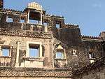
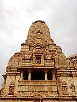
Places of interest
See also
References
- District Census Handbook Chittaurgarh. Directorate of Census Operations. 2011.
- "Statistical Data of Rajasthan State Pertaining to Census-2011". www.rajcensus.gov.in. Retrieved 7 September 2018.
- Rajasthan District Gazetteers - Chittaurgarh. Directorate of District Gazetteers. 1977.
- Ministry of Panchayati Raj (8 September 2009). "A Note on the Backward Regions Grant Fund Programme" (PDF). National Institute of Rural Development. Archived from the original (PDF) on 5 April 2012. Retrieved 27 September 2011.
- "District Census 2011". Census2011.co.in. 2011. Retrieved 30 September 2011.
- US Directorate of Intelligence. "Country Comparison:Population". Retrieved 1 October 2011.
Gabon 1,576,665
- "2010 Resident Population Data". U. S. Census Bureau. Archived from the original on 19 October 2013. Retrieved 30 September 2011.
Hawaii 1,360,301
- 2011 Census of India, Population By Mother Tongue
- Decadal Variation In Population Since 1901
External links
| Wikimedia Commons has media related to Chittorgarh district. |
Places adjacent to Chittorgarh district | ||||||||||
|---|---|---|---|---|---|---|---|---|---|---|
| ||||||||||
Places adjacent to Chittorgarh district | ||||||||||
|---|---|---|---|---|---|---|---|---|---|---|
| ||||||||||
| Outline |
|  | |||||||||||||
|---|---|---|---|---|---|---|---|---|---|---|---|---|---|---|---|
| Governance |
| ||||||||||||||
| Divisions and districts |
| ||||||||||||||
| Major cities | |||||||||||||||
| Related templates |
| ||||||||||||||