Nagaur district
Nagaur District is one of the 33 districts of the state of Rajasthan in western India. Panchayati Raj was introduced here. Area of the district is 17,718 km2. The city of Nagaur is the district headquarters.
Nagaur (Nāgaur) district | |
|---|---|
District of Rajasthan | |
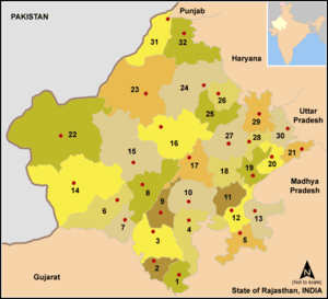
 Location of Nagaur (Nāgaur) district in Rajasthan | |
| Country | India |
| State | Rajasthan |
| Division | Ajmer division |
| Headquarters | Nagaur |
| Tehsils | Nagaur, Khinvsar, Mundwa, Jayal, Merta, Degana, Didwana, Ladnun, Parbatsar, Makrana, Nawa, Riyan BariKuchaman city |
| Area | |
| • Total | 17,718 km2 (6,841 sq mi) |
| Population (2019) | |
| • Total | 3,307,743 |
| • Density | 190/km2 (480/sq mi) |
| Time zone | UTC+05:30 (IST) |
Geography
Nagaur District is situated between 26°25' & 27°40' North Latitude & 73°.10' & 75°.15' East Longitude. The district is bounded by Bikaner District to the northwest, Churu District to the north, Sikar District to the northeast, Jaipur District to the east, Ajmer District to the southeast, Pali District to the south, and Jodhpur District to the southwest and west. The district lies in the Marwar region of Rajasthan, in the Northwestern thorn scrub forests belt surrounding the Thar Desert. The Aravalli Range extends across the southeastern portion of the district, and the saline Sambhar Lake, India's largest salt lake and Rajasthan's largest lake, lies at the southwestern corner of the district, straddling the boundary with Jaipur District. Kheduli is a historic palace where pupil of khawaja moiniddin chisti hamiduddin nagouri lived for 10 years and located on the railway line of Jaipur-Jodhpur.
Tehsils
The district consists 13 Main tehsils. These are Nagaur, Khinvsar, Jayal, Merta City, Degana, Didwana, Ladnun, Parbatsar, Makrana, Kuchaman City, Nawa, Mundwa, all of these 12 are Sub-divisions also. There are 11 blocks and 1607 villages in the district. Charbhujanath temple and meera bai mandir situated at mertacity which is known as the birth place of bhakta shiromani meerabai.
Demographics
According to the 2011 census Nagaur district has a population of 3,307,743,[1] roughly equal to the nation of Uruguay[2] or the US state of Connecticut.[3] This gives it a ranking of 102nd in India (out of a total of 640).[1] The district has a population density of 187 inhabitants per square kilometre (480/sq mi) .[1] Its population growth rate over the decade 2001-2011 was 19.25%.[1] Nagaur has a sex ratio of 948 females for every 1000 males,[1] and a literacy rate of 64.08%.[1]
At the time of the 2011 Census of India, 98.15% of the population in the district spoke Hindi and 1.71% Urdu as their first language.[4]
| Historical population | ||
|---|---|---|
| Year | Pop. | ±% p.a. |
| 1901 | 524,217 | — |
| 1911 | 559,111 | +0.65% |
| 1921 | 487,462 | −1.36% |
| 1931 | 568,434 | +1.55% |
| 1941 | 656,377 | +1.45% |
| 1951 | 763,829 | +1.53% |
| 1961 | 934,948 | +2.04% |
| 1971 | 1,262,157 | +3.05% |
| 1981 | 1,628,669 | +2.58% |
| 1991 | 2,144,810 | +2.79% |
| 2001 | 2,775,058 | +2.61% |
| 2011 | 3,307,743 | +1.77% |
| source:[5] | ||
Tourism
| Wikimedia Commons has media related to Nagaur district. |
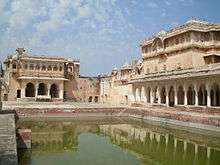
- Nagaur Fort was one of the first Muslim strongholds in northern India[6] and one of the finest examples of Jat-Mughal architecture.[7] Built in the early 12th century and repeatedly altered over subsequent centuries, it witnessed many battles. Underwent major renovations in 2007.[6][7] 90 fountains are now running in the gardens and buildings. The fort's buildings and spaces, both external and internal, serve as venue, stage and home to a Sufi Music Festival.
- Rol, also known as Rol Sharif is a village in Jayal tehsil of Nagaur district in the Indian state of Rajasthan. The village has many mosques, including Shahi Jama Masjid. There is Jubba Mubarak of Muhammad, which are said to possess holy relic brought by Qazi Hamiduddin Nagauri from Bukhara, Russia. Devotees from various parts of the country gather on urs of Quazi Sahab to celebrate the occasion. There is an annual Urs Mela (Urs Fair) organised in village.[8]
- Ladnun - 10th century's Jain temples are rich with historical attraction. Jain Vishva Bharti University - A centre of Jainism; a school of thought; a centre of spirituality & purification; a society of Ahimsa;

- Bairathal Kallan - The Bairathal Kallan village was established about 700–750 years ago.
- Khinvsar town - Khimsar Fort - Situated 42 km from Nagaur on the National Highway No. 65 towards Jodhpur; 500-year-old fort in the middle of the Thar Desert; turned into a hotel furnished with modern facilities. Mughal Emperor Aurangzeb used to stay here; Khinvsar town has 25 small temples; black deer roaming in herds are a tourist attraction.
- Jayal- Dadhimati Mata Temple - Also known as Goth-Manglod temple; 40 km from Nagaur; the oldest temple of the district constructed during the Gupta Dynasty (4th Century); Kul Devi of Dadhich Brahmins.
- Merta - Meera Bai Temple - Also known as the Charbhuja temple; 400 years old; evidence how total surrender helps attain godly qualities; how deep faith converts poison to 'Amrit'.
- Kuchaman City - Kuchaman Fort - One of the oldest & most inaccessible forts of Rajasthan, this fort is situated on top of a straight hill. Jodhpur rulers used to mint their gold and silver currency here. It affords views of the city and has been converted into a hotel.
- Khatu - Khatu's old name was Shatkup (six wells). When Shak rulers came to India then they brought two new wells with them which were called Shakandhu (Stepwell) & Kalandh (Rahat). According to Prathviraj Raso, Khatu's old name was Khatwan. Old Khatu is almost destroyed. Now there are two villages, one is called Bari Khatu & other Chhoti Khatu. On the hillock of Chhoti Khatu a small fort is standing. Fort was built by Prithviraj Chauhan. An old stepwell is located in Chhoti Khatu, known as Phool Bawadi, it is believed that this stepwell was constructed in Gurjara Pratihara period.
- Kurki - Kurki is a small village in the Merta Tehsil of Nagaur district. It is the birthplace of the princess and poet, Meera Bai, about 30 km from Merta.
- Kharnal - It is situated on the Nagaur-Jodhpur National Highway near about 15 km from Nagaur. It is the birthplace of Lok Devta Veer Tejaji. It is believed that Kharnal was established by Dhawal Khichi who was in the 5th generation of the Choudhan ruler Gundal Rao Khichi of Jayal state. Veer Tejaji was born in Dholiya Gotra of Jat.
- Untwaliya - It is situated 15 km from Nagaur and 10 km from Alai.
- Jhorda - It is situated on the north of Nagaur about 30 km away. It is the birthplace of the Saint Baba Hariram.
References
- "District Census 2011". Census2011.co.in. 2011. Retrieved 30 September 2011.
- US Directorate of Intelligence. "Country Comparison:Population". Retrieved 1 October 2011.
Uruguay 3,308,535 July 2011 est.
- "2010 Resident Population Data". U. S. Census Bureau. Retrieved 30 September 2011.
Connecticut 3,574,097
- 2011 Census of India, Population By Mother Tongue
- Decadal Variation In Population Since 1901
- "Rehabilitation of Nagaur Fort". Aga Khan Award for Architecture. Aga Khan Development Network. Retrieved 23 October 2013.
- Abraham, Melissa. "India's Vibrant Cultural Heritage Comes to Life at Nagaur Fort". The Getty Iris. Retrieved 24 October 2013.
- Rol Urs Mela nagaur.rajasthan.gov.in
External links
| Wikimedia Commons has media related to Nagaur district. |
Places adjacent to Nagaur district | |
|---|---|
| Outline |
|  | |||||||||||||
|---|---|---|---|---|---|---|---|---|---|---|---|---|---|---|---|
| Governance |
| ||||||||||||||
| Divisions and districts |
| ||||||||||||||
| Major cities | |||||||||||||||
| Related templates |
| ||||||||||||||