Jalore district
Jalore District is a district of Rajasthan state in western India. The city of Jalore is the administrative headquarters of the district. The district has an area of 10,640 km2 (4,108 sq mi) (3.11 percent of Rajasthan's area), and a population of 1,828,730 (2011 census), with a population density of 136 persons per square kilometre.
Jalore district | |
|---|---|
District of Rajasthan | |
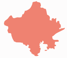
 Location of Jalore district in Rajasthan | |
| Country | India |
| State | Rajasthan |
| Area | |
| • Total | 10,640 km2 (4,110 sq mi) |
| Population (2011) | |
| • Total | 1,828,730 |
| • Density | 170/km2 (450/sq mi) |
| Time zone | UTC+05:30 (IST) |
Geography
The district is bounded on the northwest by Barmer District, on the northeast by Pali District, on the southeast by Sirohi District, and by Banaskantha District of Gujarat state on the southwest. The total area of the district is 10,640 km2 (4,108 sq mi). The altitude is 268 m, latitude is 25.22 N and longitude is 72.58 E.
Physiographically, the district is oblong in shape, extending up to Rann of Kutch (Gujarat). The region is generally plain but for some scattered thickly wooded hills in the north and some hillocks in the centre. The eastern portion of the district is rocky while the western tract is a roughly plain dotted with Sand dunes & sand ridges. In respect of its geological formation, most part of district is formed of fourth century modern century deposits. These deposits can be seen in Grid pattern formed by sand (Balu), new alluvial and old alluvial Soils. In Bhinmal Teshil's South Eastern part of Jaswantpur, highest mountains of the district are situated. the highest peak is Sundha (991 meters, 3252 feet).Luni River is the main river in the district with its tributaries Jawai, Khari, Sukri, Bandi, and Sagi. All the rivers are seasonal.
Administrative set-up
There are five sub-units Ahore, Jalore, Bhinmal-Bagoda, Raniwara and Sanchore.
Telsil headquarters are Ahore, Jalore, Sayala, Bagoda, Bhinmal, Raniwara and Sanchore. Bhadrajun has Sub-Tehsil Office. There are seven Panchayat Samitis. Jaswantpura and Chitalwana is declared to be made tehsils in Rajasthan budget-2012-13.[1]
Three Municipalities are situated at Jalore, Bhinmal and Sanchore.
The major towns and villages of the Jalore district are Siana, Hadecha, Ramsin, Daspan, Bagra, Juni Bali, Bishangarh, Ummedabad and Megalva.
There are 767 revenue villages in the district grouped under 264 Gram Panchayat villages.
Political set up
Jalore-Sirohi is one joint one parliamentary constituency. Buta Singh won three times from this parliamentary constituency . There are five legislative assembly areas namely Jalore, Ahore, Bhinmal, Raniwara and Sanchore Now at time jalore sirohi parliament member of devji.M.patel from B.J.P.
Economy

The economy of district is mainly based on agriculture and animal husbandry. The oilseeds specially mustard oil seed is predominant crop. Wheat, bajra, kharif pulses, barley, jowar and in very huge quantity of fleawort.
Of late some mineral based industries are set up based on mineral available from local mines. The main minerals produced are: Gypsum, limestone, bajari, murram, granite, and graded fluorite.
There is no large and medium size industry in the district. The main small scale industries are :granite slabs and tiles, marble cutting and polishing, mustard seed crushing, skimmed milk powder, butter and ghee, handloom cloth, leather shoes (mojari). There are four industrial areas in the district.
In 2006 the Ministry of Panchayati Raj named Jalore one of the country's 250 most backward districts (out of a total of 640).[2] It is one of the twelve districts in Rajasthan currently receiving funds from the Backward Regions Grant Fund Programme (BRGF).[2]
Infrastructure
Electricity
There are two sub grid stations of 220 KV at Jalore and Bhinmal. The district receives power from Dewari grid station in Udaipur District. Almost all villages of the district are electrified.
A small area is irrigated from water of Jawai dam. The main source of irrigation continues to be wells. Over exploitation of ground water has meant that farmers have to dig deeper. Sanchore tehsil is getting water from Narmada canal project.
Transport
National Highway no 15 (Bhatinda-Kandla) passes through the district. The total road length in the district is about 2,800 km (1,740 mi).
The district is connected by broad gauge railway line of North Western Railway. Samadari-Bhildi branch line passes through the district connecting Jalore and Bhinmal towns. There are 15 railway stations and 127 km (79 mi) of railway line in the district. The nearest airport is Jodhpur. There is also an air strip at village Noon about 35 km (22 mi) from Jalore town.
Demographics
According to the 2011 census Jalore district has a population of 1,828,730,[3] roughly equal to the nation of Kosovo[4] or the US state of Nebraska.[5] This gives it a ranking of 260th in India (out of a total of 640).[3] The district has a population density of 172 inhabitants per square kilometre (450/sq mi) .[3] Its population growth rate over the decade 2001-2011 was 26.31%.[3] Jalor has a sex ratio of 951 females for every 1000 males,[3] and a literacy rate of 55.58%.[3]
At the time of the 2011 Census of India, 99.25% of the population in the district spoke Hindi as their first language.[6]
| Historical population | ||
|---|---|---|
| Year | Pop. | ±% p.a. |
| 1901 | 271,363 | — |
| 1911 | 300,374 | +1.02% |
| 1921 | 278,888 | −0.74% |
| 1931 | 322,867 | +1.48% |
| 1941 | 368,338 | +1.33% |
| 1951 | 423,553 | +1.41% |
| 1961 | 547,072 | +2.59% |
| 1971 | 667,950 | +2.02% |
| 1981 | 903,073 | +3.06% |
| 1991 | 1,142,563 | +2.38% |
| 2001 | 1,448,940 | +2.40% |
| 2011 | 1,828,730 | +2.36% |
| source:[7] | ||
Climate
The minimum and maximum temperatures of the district are 4 degrees and 50 degrees Celsius respectively. The average rainfall is 412 mm. The climate of district is dry and with extremes.
Wildlife
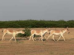
Indian Wild Ass, a rare member of Indian Wildlife seems to be increasing in numbers and extending its range from Little Rann of Kutch in the neighboring Indian State of Gujarat, where the world's last population of this subspecies had got confined to in recent years, and has gradually started moving out and colonizing Greater Rann of Kutch also extending into the neighboring State of Rajasthan in the bordering villages in Jalore district bordering the Rann of Kutch in Gujarat and in Khejariali and its neighbourhood where a 60 km2 area was transferred to the Rajasthan Forest Department by the revenue authorities in 2007. At this place Rebaris (camel and sheep breeders) live in the Prosopis juliflora jungles in the company of chinkaras, hyenas, common fox, desert cat and wolf etc.[8]
Flora: The hillocks and ridges in the area under discussion are characterised by khair (Acacia Katechu); thar (Euphabia Nerrifolia) and babuls. The plains are vegetated by awal (Casia auriculate) akra, kiker (Acacia arabica). The oilseeds specially mustard oil seed is predominant crop. Wheat, bajra, kharif pulses, barley, jowar and in very huge quantity of fleawort. However due to the scanty presence of water most of the cultivated land remains barren. Also presence of aeolian sand makes it tough for agricultural growth due its high permeability. Extensive growth of cactuses of various types is found in this area.
See also
References
- Rajasthan Budget 2012-13
- Ministry of Panchayati Raj (8 September 2009). "A Note on the Backward Regions Grant Fund Programme" (PDF). National Institute of Rural Development. Archived from the original (PDF) on 5 April 2012. Retrieved 27 September 2011.
- "District Census 2011". Census2011.co.in. 2011. Retrieved 30 September 2011.
- US Directorate of Intelligence. "Country Comparison:Population". Retrieved 1 October 2011.
Kosovo 1,825,632 July 2011 est.
- "2010 Resident Population Data". U. S. Census Bureau. Archived from the original on 19 October 2013. Retrieved 30 September 2011.
Nebraska 1,826,341
- 2011 Census of India, Population By Mother Tongue
- Decadal Variation In Population Since 1901
- Wild Ass sighted in Rajasthan villages along Gujarat; by Sunny Sebastian; 13 September 2009; The Hindu
External links
| Wikimedia Commons has media related to Jalore district. |
Places adjacent to Jalore district | ||||||||||
|---|---|---|---|---|---|---|---|---|---|---|
| ||||||||||
| Outline |
|  | |||||||||||||
|---|---|---|---|---|---|---|---|---|---|---|---|---|---|---|---|
| Governance |
| ||||||||||||||
| Divisions and districts |
| ||||||||||||||
| Major cities | |||||||||||||||
| Related templates |
| ||||||||||||||