Beawar
Beawar (pronounced [/bəˈjaːʋər/]) is a city in Ajmer district of Rajasthan, India. Beawar was the financial capital of Merwara state of Rajputana. As of 2011, the population of Beawar is 342,935. It is located 184 kilometres (114 mi) southwest of the state capital Jaipur, amidst Aravali hills. The city used to be a major center of trade, especially in raw cotton, and used to have cotton presses and the Krishna cotton mills. Currently, major industries include mineral-based units, machine-based units, machine tools and accessories, pre-stressed concrete pipes, plastic products, textiles, wooden furniture and asbestos cement pipes. Beawar is the largest producer of cement in northern India and home to Shree Cement. It is situated in a mineral-rich region having reserves of feldspar, quartz, asbestos, soapstone, magnesite, calcite, limestone, mica, emerald, granite, and masonry stone. Reserves of barytes, fluorite, wollastonite and vermiculite have also been found. Nearest airports are Jodhpur (145 km) and Jaipur (190 km). It is also connected by RSRTC operated buses to all parts of Rajasthan, and neighboring Delhi NCR, Ahmedabad (Gujarat), Gwalior (Madhya Pradesh). It also had railway connectivity with Delhi, Mumbai, Ahmadabad, Bangalore (bi-weekly), Haridwar, Dehradun (weekly), Bareilly and Kolkata.
Beawar | |
|---|---|
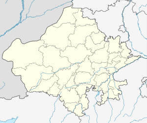 Beawar Location in Rajasthan, India  Beawar Beawar (India) | |
| Coordinates: 26.1°N 74.32°E | |
| Country | |
| State | Rajasthan |
| District | Ajmer |
| Founded by | Charles George Dixon |
| Government | |
| • Type | Municipal Council |
| • Municipality Chairman | Naresh kanojiya |
| Elevation | 439 m (1,440 ft) |
| Population (2011) | |
| • City | 342,935 |
| • Urban | 151,152 (44.1%) |
| • Rural | 191,783 (55.9%) |
| • Literacy | 64.2% |
| • Sex ratio | 970 female per 1,000 male |
| Languages | |
| • Spoken | Hindi, Marwadi |
| • Official | Hindi, English |
| Time zone | UTC+5:30 (IST) |
| PIN | 305901 |
| Area code(s) | 01462 |
| Vehicle registration | RJ-36 |
| Website | www |
History
Beawar was founded by Mustak kathat son of Della kathat (1795-1857) in 1836. Beawar was part of India, and the administrative headquarters of Merwara district. Since the ancient days, the region where Beawar lies is called Magra-Merwaran, and it was named after a local village called Beawar Khas by the rajasthani . This region was ruled by fierce trib zeees( rajput people used to call Rajputs as tribes rather than a caste.)such as the Chauhan Rajput (the descendants of Prithviraj Chauhan) the British tried to subdue them but were unsuccessful because the people were scattered across many small villages and Chauhan ruled through Shyamgarh Fort and they were excellent in conducting war. The Battle of Shyamgarh was fought between the Chauhan Rajputs and the British. The British won and Chauhans abandoned the fort of Shyamgarh, but employed guerrilla tactics causing great loss to the British. Consequently, the British founded a military cantonment with fortified walls for protection and further military missions. Another factor involved in building the cantonment here was Beawar's location at the strategic tri-junction of the royal states of Jaipur, Jodhpur, and Udaipur and near to the royal state of ((Ajmer)). Beawar the name of the city comes from the name "Be Aware" which was originally a sign given to the city by a British Emperor. Chauhan Rajput, the great warriors known for their courage was a major problem to the British Empire, so they decided to form a cantonment and hence Beawar as Nayashahar came into existence.
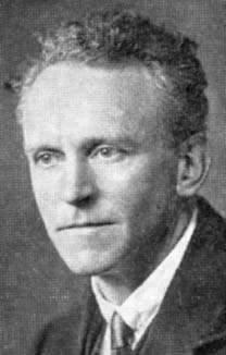
Beawar is the birthplace of classical mathematician Duncan Sommerville.[1]
Beawar city
Inner Beawar city: The inner city of Beawar is the old historical city, also called the "Walled City"; that is the main market area. It has shops for all sorts of categories, from premium Raymond shop to local grocery store.
Outer Beawar city The outer area of Beawar is a developing area. Residential expansion is taking place on Ajmer road, Sendra Road and Delwara road, specially Raas Babra Road. An Army Cantonment is being established near Roopnagar which covers a vast area and have future prospects of business trade and development there. New shopping complexes and hotels are also being built. The outer city is home to all transport hubs such as central bus station, railway station, and private tour operators. The city also has a church, some degree colleges, a shopping complex and cinema halls (Jaimandir and City centre - a newly built multiplex).
Hotels in Beawar Most of the hotels are centred on the bus stand and railway station, but as travelling patterns change, new hotels are coming up on the roads leading into town.
Education
Beawar has numerous schools and colleges spread throughout the city.
Colleges
- Sanatan Dharm Government College
- Satyam Institute of Technology
- Vardhaman girls college
- D. A. V. Girls college
- S.M.S. B.Sc. Nursing College
RBSE-affiliated schools
- Adarsh Vidhya Mandir, Beawar
- Aaryabhatta Academy
- Adarsh Vidhya Mandir sec. school
- Deeksha Baal Vidyapeeth Nursery & Secondary School, Balar Road, Beawar
- Giriraj senior secondary school Beawar
- Giriraj Senior Secondary school Ajmer Road beawar
- Godawari Girls senior sec. school
- Government Sanatan Dharma senior secondary school, Beawar
- Govt Patel senior secondary school, Beawar
- Govt Gurukul senior secondary school,Beawar
- Jain Gurukul senior sec. school
- Mohammed Ali Memorial senior sec. school
- Noondri mendratan sec. school
- St. Xavier's secondary school
- Salamat memorial school, alinagar, nundri mendratan.
- Sardar Vallabhbhai Patel senior sec. school
- Shree Chimman Singh Lodha senior sec. school
- Shri Shanti Jain senior sec. school
- Smt. Kanchan Devi Jain senior sec. school
- jai goldy English upper primary school
CBSE-affiliated schools
- Army Public School Beawar (project to be sanction by station headquarter Ajmer)
- Bhanwarlal Gothi Public Sr. Sec. English Medium School(B.L.Gothi)
- Central Academy Shree Cement
- Guru Siddharth International School
- Kendriya Vidyalaya
- Mangal Newton Sr. Sec. School
- St Paul's Sr. Sec. School
- Bangur Public School, Bangur City
- Shree Central Academy Sr. Sec. School, Bangur Nagar
- GDA School
Culture
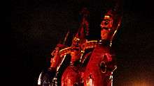
Veer Tejaji maharaj Beawar Fair is one of major fairs of town. Locals of Beawar gather to celebrate Baadshah, which means "King". The Baadshah travels across the town to reach the Mayor's office, spraying colour all over the town in celebration of Holi, the festival of colours. It is celebrated in memory of the one-day king "Agarwal".
"Baadshah" is decorated in traditional style and travels up to the magistrate office, where it plays and gives its resolutions for the public. In front of it, another person, Birbal, dances in his special style. On the day of "Baadshah", there are performances by local people in "Teliwara" as well as near the Suraj Pol gate.
Annually, the city also celebrates Dushera by burning an effigy of Ravana on the eve of Dushera.
Demographics
As of the 2011 India census, Beawar had a population of 342,935. Males constitute 51% of the population and females 49%. Beawar has an average literacy rate of 64%, higher than the national average of 59.5%; with 60% of the males and 40% of females literate. While 15% of the population is under 6 years of age.
Economy
Beawar is a hub of small scale industry (generating revenue in crores). Beawar is larger than many present district headquarters of Rajasthan. There has been demand for creating a Beawar district over the last two decades. Majority of employment is provided by RIICO.
Geography and climate
Beawar is located at 26.1° N 74.32° E. It has an average elevation of 439 metres (1440 feet).
Map of Beawar's old urban area
| Climate data for Beawar | |||||||||||||
|---|---|---|---|---|---|---|---|---|---|---|---|---|---|
| Month | Jan | Feb | Mar | Apr | May | Jun | Jul | Aug | Sep | Oct | Nov | Dec | Year |
| Average high °C (°F) | 25 (77) |
28 (82) |
34 (93) |
38 (100) |
41 (106) |
40 (104) |
36 (97) |
34 (93) |
36 (97) |
36 (97) |
31 (88) |
27 (81) |
34 (93) |
| Average low °C (°F) | 8 (46) |
12 (54) |
18 (64) |
23 (73) |
27 (81) |
29 (84) |
27 (81) |
26 (79) |
25 (77) |
20 (68) |
15 (59) |
9 (48) |
20 (68) |
| Average precipitation cm (inches) | 0.35 (0.14) |
0.27 (0.11) |
0.32 (0.13) |
0.35 (0.14) |
0.6 (0.2) |
3.26 (1.28) |
8.89 (3.50) |
6.44 (2.54) |
3.42 (1.35) |
0.45 (0.18) |
0.07 (0.03) |
0.06 (0.02) |
24.48 (9.62) |
| Source: Foreca | |||||||||||||
Surrounding municipalities
Places adjacent to Beawar | ||||||||||
|---|---|---|---|---|---|---|---|---|---|---|
| ||||||||||
Religious landmarks
- Shoolbread Memorial C. N. I. Church of Beawar Rajasthan. It is the First Church of Rajasthan at Beawar.
- Mata ji ki dungri
- Ekta Circle (Bharat Mata Circle) {between ajmeri gate to mewari gate}
- Goverdhan Nath Temple (Shree nath ji Mandir)
- Neelkanth Mahadev
- Ramdev jj ka mandir Lulwa khas
- Oldest Vishnu temple ( Shri Rang ji ) Sendra road
- Aashapura Mata ka Mandir
- Shri Sayan Mata ka Mandir (Shyam Garh)
- Ramdev Ji ka Mandir Lulwa Khas
- Sankat Mochan Hanumaan Mandir (Shree Cement)
- Dadi Dham at Ajmer Road (temple of Shri Rani Sati Dadi, a replica of the popular one located in Jhunjhnu, Rajasthan)
- Shri SumatiNath Jain Temple
- Jain Dadawari
- subhash garden( company bag)
- shri Shantinath Jain Mandir, Pali Bazar, BEAWAR
- Mahadeo ji ki Chatri (Mahadeo Temple) {between ajmeri gate to mewari gate}
- Narsing Mandir
- MAKARDHWAJ BALAJI DHAM , BALAD ROAD , NATH NAGAR , BEAWAR
References
- "Obituary" (PDF). Monthly Notices of the Royal Astronomical Society Vol. 95, pp. 330–331. Retrieved 13 April 2020.
| Outline |
|  | |||||||||||||
|---|---|---|---|---|---|---|---|---|---|---|---|---|---|---|---|
| Governance |
| ||||||||||||||
| Divisions and districts |
| ||||||||||||||
| Major cities | |||||||||||||||
| Related templates |
| ||||||||||||||