Bundi district
Bundi District is a district in the state of Rajasthan in western India. The town of Bundi is the district headquarters. It has an area of 5,550 km² and a population of 1,110,906 (2011 census). It is divided into 5 tehsils which are: Bundi, Hindoli, Nainwa, Keshoraipatan and Indergarh.
Bundi district | |
|---|---|
District of Rajasthan | |
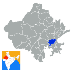 Location of Bundi district in Rajasthan | |
| Country | India |
| State | Rajasthan |
| Area | |
| • Total | 5,550 km2 (2,140 sq mi) |
| Population (2011) | |
| • Total | 1,110,906 |
| • Density | 200/km2 (520/sq mi) |
| Time zone | UTC+05:30 (IST) |
| Wikisource has the text of the 1911 Encyclopædia Britannica article Bundi. |
History
Stone Age tools dating from 5,000 to 200,000 years were found in Bundi and Bhilwara districts of the state.[1] South-east Region of Rajasthan is known as Hadoti, - the land of the Hada Rajputs. Hadas are a major branch of the Chauhan Agnikula Rajputs (hailing from fire dynasty). They had settled in the hilly terrain of Mewar, at Bambaoda, near Bijoliya in the 12C. Bundi was conquered in 1241 by Rao Deva Singh from the Meena tribals. This was the first step in the establishment of Hadauti, when the Hadas moved down from the ‘Pathar’ around Bambaoda. Bundi takes its name from the Bando Naal or the narrow passage, between the rugged hills. The town of Bundi is nestled in the cleft of the Aravali hills and has a special medieval flavor quite untouched by time. Prince Jait Singh of Bundi captured Kota in 1264 AD, and Kota became a part of Bundi as the Jaghir (land grant) of the eldest prince of Bundi. Kota became a separate state in 1624. The state of Jhalawar was formed in 1838 out of Kota territory.
Demographics
According to the 2011 census Bundi district[2] has a population of 1,110,906,[3] roughly equal to the nation of Cyprus[4] or the US state of Rhode Island.[5] This gives it a ranking of 415th in India (out of a total of 640).[3] The district has a population density of 193 inhabitants per square kilometre (500/sq mi) .[3] Its population growth rate over the decade 2001-2011 was 15.7%.[3] Bundi has a sex ratio of 922 females for every 1000 males,[3] and a literacy rate of 62.31%.[3]
At the time of the 2011 Census of India, 98.17% of the population in the district spoke Hindi and 1.02% Punjabi as their first language.[6]
| Historical population | ||
|---|---|---|
| Year | Pop. | ±% p.a. |
| 1901 | 179,256 | — |
| 1911 | 228,068 | +2.44% |
| 1921 | 196,146 | −1.50% |
| 1931 | 226,482 | +1.45% |
| 1941 | 260,420 | +1.41% |
| 1951 | 292,157 | +1.16% |
| 1961 | 353,267 | +1.92% |
| 1971 | 467,793 | +2.85% |
| 1981 | 612,017 | +2.72% |
| 1991 | 770,248 | +2.33% |
| 2001 | 962,620 | +2.25% |
| 2011 | 1,110,906 | +1.44% |
| source:[7] | ||
See also
References
- Pillai, Geetha Sunil (28 February 2017), "Stone age tools dating back 2,00,000 years found in Rajasthan", The Times of India
- "Archived copy". Archived from the original on 1 July 2013. Retrieved 2013-06-20.CS1 maint: archived copy as title (link)
- "District Census 2011". Census2011.co.in. 2011. Retrieved 30 September 2011.
- US Directorate of Intelligence. "Country Comparison:Population". Retrieved 1 October 2011.
Cyprus 1,120,489 July 2011 est.
- "2010 Resident Population Data". U. S. Census Bureau. Archived from the original on 1 January 2011. Retrieved 2011-09-30.
Rhode Island 1,052,567
- 2011 Census of India, Population By Mother Tongue
- Decadal Variation In Population Since 1901
External links
| Outline |
|  | |||||||||||||
|---|---|---|---|---|---|---|---|---|---|---|---|---|---|---|---|
| Governance |
| ||||||||||||||
| Divisions and districts |
| ||||||||||||||
| Major cities | |||||||||||||||
| Related templates |
| ||||||||||||||