Dausa district
Dausa District is a district of Rajasthan state in India within Jaipur division. The city of Dausa is the district headquarters. It has an area of 3432 km² and a population of 1,634,409 in 2011 census. It is surrounded by Alwar District in the north, Bharatpur District in the northeast, Karauli District in the southeast, Sawai Madhopur District in the south, and Jaipur District in the west. Dausa district is divided into eight tehsils - Baswa, Dausa, Lalsot, Mahwa, Sikrai, Lawan, Nangal Rajawatan and Ramgarh Panchwara. The Sawa and Ban Ganga rivers run through the district. It is situated on the National Highway 11 from Jaipur to Agra. It is 55 km to the east of Jaipur and 103 km from Sawai Madhopur.
Dausa district | |
|---|---|
District of Rajasthan | |
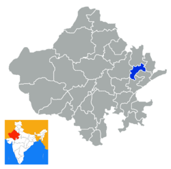 Location of Dausa district in Rajasthan | |
| Coordinates (Dausa): 26.54°N 76.19°E | |
| Country | India |
| State | Rajasthan |
| Division | Jaipur Division |
| Headquarters | Dausa |
| Area | |
| • Total | 3,432 km2 (1,325 sq mi) |
| Population (2011) | |
| • Total | 1,634,409[1] |
| Demographics | |
| • Literacy | 68.16 |
| • Sex ratio | 905 |
| Time zone | UTC+05:30 (IST) |
| Major highways | National Highway 11 (NH-11) |
| Average annual precipitation | 459.8 mm |
| Website | dausa |
History
Dausa is named after a hill near the city that was called Devgiri. On the top of hill is situated a fort, built by Badgujar kings, who were the orininal rulers of this area. Later, Dausa was given by Chauhans to Kachwahas, but the centre of their power shifted to Amber.
When Akbar went to Ajmer as a pilgrim to Khwaja Moinuddin Chisti in 1562, he stayed in Dausa and met with Rupsi Baragi, Hakim of Dausa at the time and brother of Bharmal. Agriculture is the main occupation of the people of Dausa. The main crops of the district are wheat, bajra, rapeseed, mustard and groundnuts.
Dausa District was constituted on 10 April 1991 by separating four tehsils, namely Dausa, Baswa, Sikrai, & Lalsot from Jaipur district. Mahwa Tehsil of Sawai Madhopur was included in this district on 15 August 1992.
Statistical data
Dausa is not the smallest district of Rajasthan by area. Dholpur is the smallest district, at 3,034 square km, while Dausa is 3,432 square km.
Demographics
| Historical population | ||
|---|---|---|
| Year | Pop. | ±% p.a. |
| 1901 | 321,510 | — |
| 1911 | 305,507 | −0.51% |
| 1921 | 254,843 | −1.80% |
| 1931 | 283,384 | +1.07% |
| 1941 | 322,117 | +1.29% |
| 1951 | 403,207 | +2.27% |
| 1961 | 473,905 | +1.63% |
| 1971 | 588,702 | +2.19% |
| 1981 | 763,706 | +2.64% |
| 1991 | 999,227 | +2.72% |
| 2001 | 1,323,002 | +2.85% |
| 2011 | 1,634,409 | +2.14% |
| source:[2] | ||
According to the 2011 census Dausa district has a population of 1,634,409, with a population density of 476 persons per km²,[3] roughly equal to the nation of Guinea-Bissau[4] or the US state of Idaho.[5] This gives it a ranking of 305th in India (out of a total of 640).[3] The district has a population density of 476 inhabitants per square kilometre (1,230/sq mi) .[3] Its population growth rate over the decade 2001-2011 was 24.31%.[3] Dausa has a sex ratio of 905 females for every 1000 males,[3] and a literacy rate of 68.16%, with male literacy at 82.98% and female literacy at 51.93%.[3]
At the time of the 2011 Census of India, 99.88% of the population in the district spoke Hindi as their first language.[6]
References
- "Name Census 2011, Dausa Handbook data" (PDF). censusindia.gov.in. 2016. Retrieved 28 February 2016.
- Decadal Variation In Population Since 1901
- "District Census 2011" (PDF). Indian govt. 2011. Retrieved 10 December 2019.
- US Directorate of Intelligence. "Country Comparison:Population". Retrieved 1 October 2011.
Guinea-Bissau 1,596,677 July 2011 est.
- "2010 Resident Population Data". U. S. Census Bureau. Archived from the original on 19 October 2013. Retrieved 30 September 2011.
Idaho 1,567,582
- "C-16 Population By Mother Tongue - Rajasthan". censusindia.gov.in. Retrieved 2 October 2019.
External links
| Wikimedia Commons has media related to Dausa district. |
Places adjacent to Dausa district | |
|---|---|
| Outline |
|  | |||||||||||||
|---|---|---|---|---|---|---|---|---|---|---|---|---|---|---|---|
| Governance |
| ||||||||||||||
| Divisions and districts |
| ||||||||||||||
| Major cities | |||||||||||||||
| Related templates |
| ||||||||||||||