Jhalawar
Jhalawar (झालावाड़) (![]()
Jhalawar | |
|---|---|
City | |
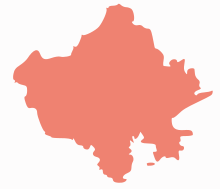
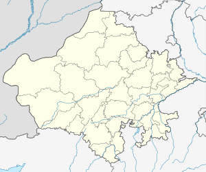 Jhalawar Location in Rajasthan, India  Jhalawar Jhalawar (India)  Jhalawar Jhalawar (Asia) | |
| Coordinates: 24.59°N 76.16°E | |
| Country | |
| State | Rajasthan |
| District | Jhalawar |
| Division | Kota Division |
| Government | |
| • Type | Municipal Council |
| • Body | Nagar Parishad |
| Elevation | 312 m (1,024 ft) |
| Population (2011)[1] | |
| • Total | 66,919 |
| Languages | |
| • Official | Hindi |
| Time zone | UTC+5:30 (IST) |
| Vehicle registration | RJ-17 |
History
The city of Jhalawar was founded by a Rajput Jhala Zalim Singh,[4] who was then the Dewan of Kota State (1791 A.D.). He established this township, then known as Chaoni Umedpura, as a cantonment. The township was at the time surrounded by dense forests and wildlife.
Jhala Zalim Singh often came here for hunting and he liked the place so much that he wanted to develop it as a township. The objective to develop this place as a military cantonment was due to the fact that Maratha invaders passed through this central place from Malwa towards Kota to capture Hadoti states.
Jhala Zalim Singh recognised the importance of this place and started to develop it as a military cantonment and township, so that he could use this place to attack and stop Maratha invaders before they could reach Kota state. Chaoni Umedpura was developed as a cantonment and township around 1803-04 A.D. Colonel Todd, who visited the region in December 1821 described this area as the cantonment established by Jhala Zalim Singh plus a well-established township with large houses, havelis, and surrounding walls.
In 1838 A.D., English rulers separated Jhalawar state from Kota state and gave it to Jhala Madan Singh, the grandson of Jhala Zalim Singh. He developed his administration services to develop the state of Jhalawar. He resided in Jhalara Patan for a long time and started to build the Garh Palace (1840 - 1845 A.D). He was the first ruler of Jhalawar state and made a significant contribution in the history of Jhalawar. Jhala Madan Singh ruled Jhalawar from 1838 to 1845. After his death, Jhala Prithvi Singh became the ruler of Jhalawar, and ruled for around 30 years.
Rana Bhawani Singh Ji, who ruled Jhalawar state from 1899 to 1929 A.D., did remarkable work in the development of Jhalawar state. His active involvement was in the fields of social activities, public works (construction), education and administration.
The chief town of Jhalawar, also known as Patan or Jhalara Patan, was the centre of trade for the eponymous princely state, the chief exports of the which were opium, oil-seeds, and cotton. The palace is four miles (6 km) north of the town. An extensive ruin near the town is the site of the ancient city of Chandrawati, said to have been destroyed in the reign of Aurangzeb. The finest feature of its remains is the temple of Sitaleswar Mahadeva (c. 600).
Princely State of Jhalawar
The former ruling family of Jhalawar belonged to the Jhala family of Rajputs. At Kota Madhu Singh, a Jhala Rajput became a favourite with the Maharaja, and received from him an important post, which became hereditary. On the death of one of the Kota rajas (1771), the state was left to the charge of Jhala Zalim Singh, a descendant of Madhu Singh.
From that time Zalim Singh was the de facto ruler of Kota. Under his administration, which lasted over forty-five years, the Kota territory was respected by all parties. In 1838 AD, British intervention and internal politics resulted with the decision to dismember the Kota state, and to create the new principality of Jhalawar as a separate provision for the descendants of Jhala Zalim Singh. The districts then severed from Kota were considered to represent one-third (120,000) of the income of Kotah; by treaty they acknowledged the supremacy of the British, and agreed to pay an annual tribute of Rs. 8000/-. Madan Singh received the title of Maharaja Rana, and was placed on the same footing as the other chiefs in Rajputana.
Geography
Jhalawar is located at 24.6°N 76.15°E.[5] It has an average elevation of 312 metres (1023 feet).
Climate
The climate of the area is identical to the Indo-Gangetic plain. In summer the temperature generally is around 40 °C (104 °F) and at maximum can exceed 45 °C (113 °F). In winter the coldest temperature can reach 1 °C (34 °F). Jhalawar district has the highest rainfall in the Rajasthan state. An average of 35 inches (890 mm) of rainfall keeps it cool, and gentle breezes ward off the stifling humidity. Jhalawar district receive the maximum annual rain(95 cm)in Rajasthan.[6]
Demographics
As of 2011 Indian Census, Jhalawar had a total population of 66,919, of which 34,765 were males and 32,154 were females. Population within the age group of 0 to 6 years was 8,919. The total number of literates in Jhalawar was 48,145, which constituted 71.95% of the population with male literacy was 77.9% and female literacy was 65.5%. The effective literacy rate of 7+ population of Bahraich was 83.0%, of which male literacy rate was 90.1% and female literacy rate was 75.4%. The Scheduled Castes and Scheduled Tribes population was 11,422 and 3,534 respectively. Jhalawar had 13595 households in 2011.[1]
Education
Jhalawar district has a well-developed education infrastructure.[7] The Department of Primary Education and Department of Secondary Education provide their services through primary schools, middle schools, secondary, and senior secondary schools. The Rajiv Gandhi Pathashala (School) Scheme, run by the Government of Rajasthan, is also running in the district to provide primary education.
There are eight colleges in the district, which provide higher-level education in various streams.
- Government P. G. College, Jhalawar
- Government Girls College, Jhalawar
- Government Law College Jhalawar
- Government Horticulture & Forestry College, Jhalawar
- Government Engineering College, Jhalawar
- Polytechnic College Jhalawar
- Jhalawar Medical College
- Government Birla College, Bhawani Mandi
- Government College, Chaumahla
Places to see
- Gagron Fort[8]
- Bhim Sagar Dam[9]
- Chandrabhaga temple[10]
- Kalisindh Dam
- Gagron Dargah[11]
- Kalisindh Thermal Power Station
- Kolvi Caves
Temples
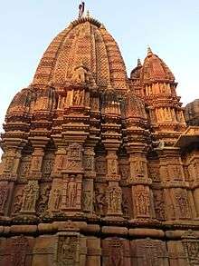
- Sun temple, Jhalrapatan : The 11th/12th-century Sun temple of Jhalprapatan is situated in the centre of the town. The temple is intact and divided into a sanctum, vestibule, prayer hall, and entrance. The most significant part of the temple is its big spire. The temple is adorned with several sculptures of gods and goddesses, and floral designs both from inside and outside of the pillars of the prayer hall are carved and decorated with sculptures. The temple has entrances on three sides, and every entrance has a toran over it. The sanctum is plain and simple. The outer walls of the sanctum display the icons of Dikpalas Surya, sur-sundris. Ganesh and other miniature scenes are related to the life of the people. At present, the image of the god Padmnabh of the 19th century is under worship and kept in the sanctum. Sometime in the 19th century the roof of the prayer hall was repaired and a few cenotaphs were constructed in the Rajput architectural style. The images of saints and monkeys were also installed on the roof.
- Chandkheri Jain Temple, Khanpur: Chandkheri is a 17th Century Jain Temple constructed by Bhattaraka Jagatkeertiji. The temple is known for its architecture. This temple is dedicated to Adinatha (Rishabhanatha) and the moolnayak of the temple is a 6.25 feet idol of Adinatha in padmasan posture made up of red stone. The idol said to be more than 1500 years old.[12] It is said that there is an idol of Bhagwan Chandra Prabhu made of jewels, but it is closed by a wall now.[13] The temple also has a Dharamshala equipped with all modern facilities along with a bhojanalya.[14]
- Shri 1008 Shantinath Digambar Jain temple, Jhalrapatan: Shantinath Jain Temple was built in the 11th century. The temple has fine carvings and sculptures.[15][16] Jain Temple is decorated with two white elephants at the entry point of the main temple.
Transport
Air
The nearest airport with scheduled commercial flight is Kota. Kota airport operates a single flight to Jaipur and New Delhi six days a week (not on Sundays). It is 82 km from the town of Jhalawar.
The alternate airport with scheduled commercial flights is Raja Bhoj Airport at Bhopal and Devi Ahilya Bai Holkar Airport at Indore in Madhya Pradesh. Kolana Airport is located near Jhalawar. It is used by chartered aircraft.
Rail
Jhalawar has a newly constructed railway station. The railway station is 2 km from Jhalawar. Currently, there are 3 trains to Kota on a daily basis with convenient timings.[17]
Road
Jhalawar town lies on National Highway No. 52. Many government buses go through the district and outside. Private buses are also available for intrastate and interstate travel.
Thermal power station
Kalisindh Thermal Power Station is 12 kilometres (7 mi) from Jhalawar town. The power plant is operated by Rajasthan Rajya Vidyut Utpadan Nigam.[18][19] Its chimney is 275 metres (902 ft) high. The two cooling towers of the facility are 202 metres (663 ft), the tallest in the world. The EPC contractor for the project is BGR Energy Systems Ltd.[20]
References
- "Census of India: Jhalawar". www.censusindia.gov.in. Retrieved 22 December 2019.
- Jhalawar-Rajasthan. "History". jhalawar.rajasthan.gov.in. Retrieved 16 September 2017.
- Soszynski, Henry. "JHALAWAR". members.iinet.net.au. Archived from the original on 10 November 2017. Retrieved 16 September 2017.
- Shastri, R.P. (1971). "Jhala Zalim Singh (1730-1823)". Jhala Zalim Singh (1730-1823), the de facto ruler of Kota: who also dominated Bundi & Udaipur - Shrewd Politician, Administrator and Reformer. Printed at Raj Printing Works, 1971.
- "Maps, Weather, and Airports for Jhalawar, India". www.fallingrain.com.
- http://waterresources.rajasthan.gov.in/1rainfall.htm
- District of Rajasthan, Jhalawar. "Jhalawar District Education". Archived from the original on 4 March 2012. Retrieved 24 March 2012.
- "Jhalawar Tourism: Tourist Places in Jhalawar - Rajasthan Tourism". tourism.rajasthan.gov.in. Retrieved 16 September 2017.
- "Bhimsagar Dam - JhalawarCity". jhalawarcity.com.
- "Hadoti Tourism Development Society". www.bundikota.com.
- "Jhalawar.biz - Gagron Dargah - मिट्ठे महावली सरकार Jhalawar". jhalawar.biz.
- "Shri Adinath Dig. Jain Atishaya Kshetra Chandkheri - JainTeerth.com".
- "Chandkheri jain temple". Jain Encyclopedia. Archived from the original on 2 May 2017. Retrieved 23 February 2019.
- "Tourism in Jhalawar, Best Places in Jhalawar". TourismGuideIndia.com. Archived from the original on 29 June 2018. Retrieved 23 February 2019.
- "Tourist Places". jhalawar.rajasthan.gov.in. Retrieved 23 February 2019.
- "Jhalawar Tourism: Tourist Places in Jhalawar". www.tourism.rajasthan.gov.in. Retrieved 23 February 2019.
- "Kota - Jhalawar City Passenger (UnReserved)/59838 Time Table/Schedule: Kota to Jhalawar WCR/West Central Zone - Railway Enquiry". indiarailinfo.com. Retrieved 17 November 2018.
- admin@steelguru.com. "First unit of coal based Kalisindh thermal power plant has commenced generation". SteelGuru India.
- India, Press Trust of (22 March 2014). "Kalisindh thermal power plant starts power generation". Business Standard India – via Business Standard.
- "Rvunl.com Is For Sale". rvunl.com.
External links
- Chisholm, Hugh, ed. (1911). . Encyclopædia Britannica. 15 (11th ed.). Cambridge University Press. p. 412.
- Bhim Sagar Dam
- jhalawar.biz classified website
- Jhalawar District website
- Jhalawar guide
- Jhalawar district map (Invest Rajasthan)
- Genealogy of the chiefs of Jhalawar
- Jhalawar (Lok Sabha constituency)
| Outline |
|  | |||||||||||||
|---|---|---|---|---|---|---|---|---|---|---|---|---|---|---|---|
| Governance |
| ||||||||||||||
| Divisions and districts |
| ||||||||||||||
| Major cities | |||||||||||||||
| Related templates |
| ||||||||||||||