Baran district
Baran district (बरन / बारां) is a district in the Indian state of Rajasthan. The headquarters of the district are located at the city of Baran.[1]
Baran | |
|---|---|
 | |
| Coordinates: 25.1°N 76.52°E | |
| Country | India |
| State | Rajasthan |
| Headquarters | Baran, Rajasthan |
| Area | |
| • Total | 6,992 km2 (2,700 sq mi) |
| Elevation | 262 m (860 ft) |
| Population (2011)[2] | |
| • Total | 1,222,755 |
| • Density | 170/km2 (450/sq mi) |
| Languages | |
| • Official | Hindi |
| Time zone | UTC+5:30 (IST) |
| PIN | 325205 |
| Telephone code | 07453 |
| Vehicle registration | RJ-28 |
| Website | Baran District |
History
Before Indian independence in 1947, most of present-day Baran District was part of the princely state of Kota. It was formed on 10 April 1991 by carving out Kota district.[3]
The 10th century Bhand Deva Temple in the style of Khajuraho Group of Monuments is situated on the banks of a pond in the centre of the 4 km wide Ramgarh crater about 40 km from the city of Baran, Rajasthan as well as 240 km from the Dhala crater.
Geography
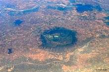
Baran is located at 25.1°N 76.52°E.[4] It has an average elevation of 262 metres (859 feet). Located in the Kota Plateau of Vindhya range, district is the location of famous Ramgarh crater made from the meteorite strike.
Rivers
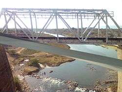
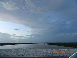
Kali Sindh, Parvati River, Parwan River, Andheri, Ban-Ganga are the major rivers.
Climate
The City has a dry climate except in the monsoon seasons. The winter season runs from mid of November to February and summer season runs from March to mid of June. The period from mid of June to September is the monsoon season followed by the months October to mid of November constitute the post monsoon or the retreating monsoon. The average rainfall in the district is 895.2mm. January is the coldest month with the average daily maximum temperature of 24.3'C and the average daily minimum temperature of 10.6'C.
Demographics
According to the 2011 census the Baran district had a population of 1,222,755.[1] It roughly equals to the nation of Trinidad and Tobago[5] or the US state of New Hampshire.[6] This gives it a ranking of 389th in India (out of a total of 640). The district has a population density of 175 inhabitants per square kilometre (450/sq mi). Its population growth rate over the decade 2001-2011 was 19.8%. Baran has a sex ratio of 926 females for every 1000 males, and a literacy rate of 67.38%.[1]
At the time of the 2011 Census of India, 96.86% of the population in the district spoke Hindi, 1.92% Urdu and 0.55% Bengali as their first language.[7]
Transport
Roadways
The city is connected with neighbouring districts and with major cities outside the state. National Highway No.76 (now National Highway No. 27) passes through the district. National Highway No.76 (now National Highway No. 27) is a part of East-West Corridor.
Airways
The nearest major airports are located at Jaipur International Airport, Udaipur Airport, and Jodhpur Airport. These airports connect Rajasthan with the major cities of India such as Delhi and Mumbai. There are two other airports in Kota and Jaisalmer, but are not open for commercial/civilian flights yet.
Railway
Baran station is situated on Kota-Bina section of Western Central Railways. It is about 67 km from Kota Junction.
Cuisine
Typical dishes include Dal Baati Churma, Roti (chapati).
References
- "District Census Handbook - Baran" (PDF). Census of India. pp. 10–11, 14. Retrieved 19 January 2015.
- "Population". rajasthan.gov.in.
- "Home". rajasthan.gov.in.
- "Maps, Weather, and Airports for Baran, India". fallingrain.com.
- US Directorate of Intelligence. "Country Comparison:Population". Retrieved 1 October 2011.
Trinidad and Tobago 1,227,505 July 2011 est.
- "2010 Resident Population Data". U. S. Census Bureau. Archived from the original on 19 October 2013. Retrieved 30 September 2011.
New Hampshire 1,316,470
- 2011 Census of India, Population By Mother Tongue
External links
| Wikimedia Commons has media related to Baran district. |
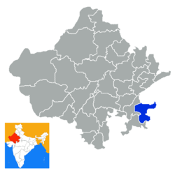
Places adjacent to Baran district | |
|---|---|
| Outline |
|  | |||||||||||||
|---|---|---|---|---|---|---|---|---|---|---|---|---|---|---|---|
| Governance |
| ||||||||||||||
| Divisions and districts |
| ||||||||||||||
| Major cities | |||||||||||||||
| Related templates |
| ||||||||||||||