Udaipur district
Udaipur district is one of the 33 districts of Rajasthan state in western India.[2] The historic city of Udaipur is the administrative headquarters of the district.[1] The district is part of the Mewar region of Rajasthan.[3]
Udaipur district | |
|---|---|
District of Rajasthan | |
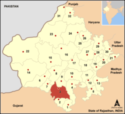 Location of Udaipur district in Rajasthan | |
| Coordinates (Udaipur): 24°23′N 73°37′E | |
| Country | India |
| State | Rajasthan |
| Division | Udaipur Division |
| Headquarters | Udaipur |
| Tehsils | 1.Badgaon 2.Bhindar 3.Girwa 4.Gogunda 5.Jhadol 6.Kanor 7.Kherwara 8.Kotra 9.Lasadiya 10.Mavli 11.Rishabhdeo 12.Salumbar 13.Semari 14.Sarada 15.Vallabhnagar |
| Government | |
| • Lok Sabha constituencies | District spread over 2 constituencies - Udaipur and Chittorgarh |
| • Vidhan Sabha constituencies | 9 |
| Area | |
| • Total | 11,724 km2 (4,527 sq mi) |
| Population (2011) | |
| • Total | 3,068,420 |
| • Density | 260/km2 (680/sq mi) |
| • Urban | 19.83% |
| Demographics | |
| • Literacy | 61.82%[1] |
| • Sex ratio | 958 |
| Languages | |
| • Official | Hindi |
| • Regional | Mewari |
| Time zone | UTC+05:30 (IST) |
| Major highways | National Highways 8, 76 |
| Average annual precipitation | 554 mm |
| Website | udaipur |
History
Before Udaipur district was established in independent India, it was a part of former Mewar or Udaipur State,[1] comprising little less than half the portion of the former state.[3]
With the formation of the United State of Rajasthan in 1948, parts of the erstwhile district of Girwa, Khamnor, Rajnagar, Bhim, Magra, Kherwara and Kumbhalgarh, together with the thikanas of Nathdwara, Kankroli, Salumbar (excluding Saira tehsil), Bhinder, Kanor, Bansi, Bari Sadri, Amet, Sardargarh, Deogarh and Gogunda were combined to constitute the district of Udaipur.[1]
During the decadal period 1951-61, two new tehsils - Nathdwara and Gogunda - were created in the district.[3] In 1991, seven tehsils of Udaipur district (Bhim, Deogarh, Amet, Kumbhalgarh, Rajsamand, Nathdwara and Railmagra) were transferred out of Udaipur district to create the new district of Rajsamand.[1] Since then, several new tehsils have been created by restructuring or dividing existing tehsils; such new tehsils include Rishabhdeo and Lasadiya created in 2008[1], Badgaon in 2012[4], Bhindar in 2017[5], and Kanor in 2018.[6]
Geography
The area of Udaipur District is 11,724 square kilometres.[7] The district is characterized by hilly terrain, with hills in the west and south, an elevated plateau in the north, and plains in the east.[3][8] The western part of the district is drained by the Sabarmati, Wakal and Sei rivers, while the southeastern part of the district is drained by Jakham, Gomti and Som rivers.[8]
Udaipur district bounded on the northwest by the Aravalli Range, across which lie the districts of Sirohi and Pali.[9] It is bounded on the north by Rajsamand District, on the east by Chittaurgarh District and Pratapgarh District, on the south by Dungarpur District, and on the southwest by the state of Gujarat.[9]
The continental watershed, in the form of the Aravalli range, passes through the district, with the northeastern part of the district draining to the Bay of Bengal and the southwestern part draining to the Gulf of Khambhat.[10] 47% of the district's area lies in the Mahi basin, 30% in Sabarmati basin, and 23% in the Banas basin.[10] The average annual rainfall of the district is 637 mm.[8]
Demographics
According to the 2011 census Udaipur district has a population of 3,068,420,[11] roughly equal to the nation of Oman[12] or the US state of Iowa.[13] This gives it a ranking of 118th in India (out of a total of 640).[11] The district has a population density of 242 inhabitants per square kilometre (630/sq mi) .[11] Its population growth rate over the decade 2001-2011 was 23.66%.[11] Udaipur has a sex ratio of 958 females for every 1000 males,[11] and a literacy rate of 62.74%.[11]
At the time of the 2011 Census of India, 77.68% of the population in the district spoke Hindi, 19.23% Bhili, 1.06% Punjabi, 0.67% Urdu and 0.45% Sindhi as their first language.[14]
Several areas of the district are classified as Scheduled Areas because of large tribal populations in these areas.[15] Scheduled Areas in the district include the entire tehsils of Kotra, Jhadol, Lasadiya, Salumber, Sarada, Kherwara, Rishabhdeo, and Gogunda, and portions of Girwa, Mavli, and Vallabhnagar tehsils.[15] Among 2,479 villages in the district, 1,945 villages (78%) are designed as being under the Tribal Sub-Plan.[16]
| Historical population | ||
|---|---|---|
| Year | Pop. | ±% p.a. |
| 1901 | 347,896 | — |
| 1911 | 430,225 | +2.15% |
| 1921 | 456,868 | +0.60% |
| 1931 | 522,826 | +1.36% |
| 1941 | 623,505 | +1.78% |
| 1951 | 733,014 | +1.63% |
| 1961 | 909,566 | +2.18% |
| 1971 | 1,185,788 | +2.69% |
| 1981 | 1,574,876 | +2.88% |
| 1991 | 1,952,388 | +2.17% |
| 2001 | 2,481,201 | +2.43% |
| 2011 | 3,068,420 | +2.15% |
| source:[17] | ||
Economy
The economy of Udaipur district is primarily dependent on agriculture with 61.7 percent workers in the district engaged as cultivators or agricultural labourers.[1]
In 2006 the Ministry of Panchayati Raj named Udaipur one of the country's 250 most backward districts (out of a total of 640).[18] It is one of the twelve districts in Rajasthan currently receiving funds from the Backward Regions Grant Fund Programme (BRGF).[18]
Udaipur district is rich in mineral resources, and produces greater value of minerals than the rest of the state combined.[1] The important metallic minerals found in the district are orc of copper, lead, zinc and silver.[1] Important non-metallic minerals found in the district are rock phosphate, asbestos, limestone, and marble.[19]
Divisions, Subdivisions and Tehsils
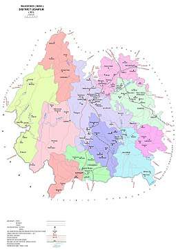
Udaipur district comprises eight sub-divisions: Girwa, Kherwada, Mavli, Vallabhnagar, Kotda, Jhadol, Rishabhdev and Salumber.[1] These sub-divisions are further divided into 15 tehsils.[20] Girwa sub-division consists two tehsils: Girwa and Gogunda.[1] Kherwada sub-division also comprises two tehsils: Kherwada and Rishabhdev. [1] Each of the sub-divisions, Mavli, Vallabhnagar, Kotda and Jhadol comprise only one tehsil of the same name.[1] Salumber sub-division comprises three tehsils: Lasadiya, Salumbar and Sarada.[1]
See also
References
- District Census Handbook Udaipur, Village and Town Directory Part XII-A. Series-09, Part XII-A. Directorate of Census Operations Rajasthan. 2011.
- "Statistical Data of Rajasthan State Pertaining to Census-2011". www.rajcensus.gov.in. Retrieved 7 September 2018.
- Agarwal, B.D. (1979). Rajasthan District Gazeteers Udaipur. Jaipur: Directorate of District Gazeteers.
- "Badgaon bani tehsil". Udaipur News. 18 June 2012. Retrieved 18 April 2019.
- "Saat jilo mein nau nai tehsilo ka gathan". Dainik Bhaskar. 8 November 2017. Retrieved 18 April 2019.
- "Notification No. P9(1) Raj / Group -1 / 2018". Revenue Board. Government of Rajasthan. 16 July 2018. Retrieved 18 April 2019.
- जिला एक दृष्टी मैं, जिला उदयपुर (District at a Glance, Udaipur District) (PDF). Udaipur: Office of Deputy Director Economic and Statistics. 2016.
- Ground Water Scenario, Udaipur District, Rajasthan (PDF). Jaipur: Central Ground Water Board. 2013.
- "Rajasthan Administrative Divisions 2011" (PDF). Census of India. Retrieved 7 September 2018.
- Study on Planning of Water Resources of Rajasthan. Tahal Group. 2014. Retrieved 24 May 2019.
- "District Census Handbook Udaipur, Village and Town Wise Primary Census Abstract Part XII-B". Census2011.co.in. 2011. Retrieved 30 September 2011.
- US Directorate of Intelligence. "Country Comparison:Population". Retrieved 1 October 2011.
Oman 3,027,959
- "2010 Resident Population Data". U. S. Census Bureau. Retrieved 30 September 2011.
Iowa 3,046,355
- 2011 Census of India, Population By Mother Tongue
- "Gazette of India". Government of India. 19 May 2019. Retrieved 13 April 2019.
- "TSP mein jude Udaipur ke 342 gaon, pahle 1612 the, ab 1954 hue". Dainik Bhaskar. 12 July 2018. Retrieved 20 April 2019.
- Decadal Variation In Population Since 1901
- Ministry of Panchayati Raj (8 September 2009). "A Note on the Backward Regions Grant Fund Programme" (PDF). National Institute of Rural Development. Archived from the original (PDF) on 5 April 2012. Retrieved 27 September 2011.
- "Brief Industrial Profile of Udaipur District" (PDF). Dcmsme.gov.in. Government of India - Ministry of MSME. Retrieved 21 July 2015.
- "Telephone Directory". Official Website of Udaipur. Retrieved 18 April 2019.
External links
| Wikimedia Commons has media related to Udaipur district. |
Places adjacent to Udaipur district | ||||||||||
|---|---|---|---|---|---|---|---|---|---|---|
| ||||||||||
| Outline |
|  | |||||||||||||
|---|---|---|---|---|---|---|---|---|---|---|---|---|---|---|---|
| Governance |
| ||||||||||||||
| Divisions and districts |
| ||||||||||||||
| Major cities | |||||||||||||||
| Related templates |
| ||||||||||||||