Bharatpur, Rajasthan
Bharatpur is a city and a Municipal Corporation in the Indian state of Rajasthan with 65 wards. The city is situated 180 km south of India's capital, New Delhi, 178 km from Rajasthan's capital Jaipur, 55 km west of Agra of Uttar Pradesh and 38 km from Mathura of Uttar Pradesh. It is also the administrative headquarters of Bharatpur District and the headquarters of Bharatpur Division of Rajasthan State. Bharatpur is part of National Capital Region (NCR) of India.[1] the city was the capital of the erstwhile, Bharatpur State.
Bharatpur Lohagarh | |
|---|---|
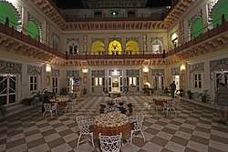 Laxmi Vilas Palace | |
| Nickname(s): Lohagarh | |
 Bharatpur Location in Rajasthan, India 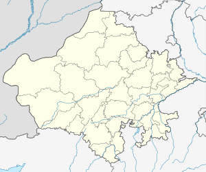 Bharatpur Bharatpur (Rajasthan) | |
| Coordinates: 27.22°N 77.48°E | |
| Country | |
| State | Rajasthan |
| District | Bharatpur |
| Named for | Bharat- A historical warrior famous in the area |
| Government | |
| • Type | Mayor-council |
| • Body | Bharatpur Municipal Corporation |
| Elevation | 183 m (600 ft) |
| Population (2011) | |
| • Total | 254,846 |
| Languages | |
| • Official | Hindi, English |
| • Other | Braj Bhasha, Mewati |
| Time zone | UTC+5:30 (IST) |
| PIN | 321001 |
| Area code(s) | (+91) 5644 |
| ISO 3166 code | RJ-IN |
| Vehicle registration | RJ-05 |
| Website | http://bharatpur.rajasthan.gov.in |
The city has an average elevation of 183 metres (600 ft) and is also known as "Lohagarh" and the "Eastern Gateway to Rajasthan".[2]
Demographics
As of 2011 Indian census,[3] Bharatpur district had a population of 2,548,462 of which males are 1,355,726 and females are 1,192,736. Bharatpur has an average literacy rate of 82.13%, higher than the national average of 74.04%; with male literacy of 90.41% and female literacy of 72.80%.
Population
| Year | Population |
|---|---|
| 1891 | 43,000 |
| 1911 | 44,000 |
| 1941 | 35,500 |
| 1951 | 37,300 |
| 1961 | 49,800 |
| 1971 | 69,400 |
| 1981 | 105,200 |
| 1991 | 156,900 |
| 2001 | 205,235 |
| 2011 | 252,838 |
| 2014 | 320,559 |
| Population Growth of Bharatpur City | |||
|---|---|---|---|
| Census | Population | %± | |
| 1891 | 43,000 | — | |
| 1911 | 44,000 | — | |
| 1941 | 35,500 | — | |
| 1951 | 37,300 | 5.1% | |
| 1961 | 49,800 | 33.5% | |
| 1971 | 69,400 | 39.4% | |
| 1981 | 105,200 | 51.6% | |
| 1991 | 156,900 | 49.1% | |
| 2001 | 205,235 | 30.8% | |
| 2011 | 252,883 | 23.2% | |
| source:[4] | |||
Further reading
| Wikimedia Commons has media related to Bharatpur. |
- Imperial Gazetteer of India Vol 8, P-73 Bharatpur State
- R. C. Majumdar, H. C. Raychaudhury, Kalikaranjan Datta: An Advanced History of India, fourth edition, 1978, ISBN 0-333-90298-X, p. 535-36
- Female infanticide and child marriage
References
- "NCR expanded to include Bhiwani, Bharatpur". The Hindu. Chennai, India. 2 July 2013.
- "Bharatpur – Eastern Gateway to Rajasthan". Archived from the original on 5 October 2013.
- "Census of India 2001: Data from the 2001 Census, including cities, villages and towns (Provisional)". Census Commission of India. Archived from the original on 16 June 2004. Retrieved 1 November 2008.
- "Historical Census of India".
- "Census of Bhartpur".
| Outline |
|  | |||||||||||||
|---|---|---|---|---|---|---|---|---|---|---|---|---|---|---|---|
| Governance |
| ||||||||||||||
| Divisions and districts |
| ||||||||||||||
| Major cities | |||||||||||||||
| Related templates |
| ||||||||||||||