Shire of Ngaanyatjarraku
The Shire of Ngaanyatjarraku is a remote local government area in Western Australia near the Northern Territory/South Australian border. It is 1,542 km from Perth.
| Shire of Ngaanyatjarraku Western Australia | |||||||||||||||
|---|---|---|---|---|---|---|---|---|---|---|---|---|---|---|---|
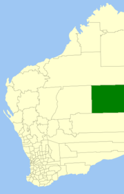 Location in Western Australia | |||||||||||||||
| Population | 1,606 (2016 census)[1] | ||||||||||||||
| • Density | 0.0099917/km2 (0.025878/sq mi) | ||||||||||||||
| Area | 160,732.9 km2 (62,059.3 sq mi) | ||||||||||||||
| Mayor | Damian McLean | ||||||||||||||
| Council seat | Warburton | ||||||||||||||
| Region | Goldfields-Esperance | ||||||||||||||
| State electorate(s) | Kalgoorlie, Pilbara | ||||||||||||||
| Federal Division(s) | O'Connor | ||||||||||||||
 | |||||||||||||||
| Website | Shire of Ngaanyatjarraku | ||||||||||||||
| |||||||||||||||
It was formed on 1 July 1993 following a report of the Local Government Boundaries Commission in 1992. The Shire of Wiluna was divided with the eastern area becoming the new Shire.
It is a community of interest within the traditional lands of the Ngaanyatjarra people of the Central Desert of Western Australia. The 99-year leases held by the Ngaanyatjarra Land Council on behalf of the traditional owners also form the boundaries of the Shire of Ngaanyatjarraku.
The Shire has 560 km of gravel road and is far from bitumen roads.
The Federal Court of Australia on 29 June 2005 consented to the Native Title claim over approximately 187,700 square kilometres (About the size of Syria) of land in the Central Desert Region in the Shires of Laverton and Ngaanyatjarraku.
Ngaanyatjarra is the first language of most residents (65%, see below) with the other language significantly represented being Pitjantjatjara.
Population
The 2011 ABS Census indicated that the region's 1,437 residents comprised 48.8% males and 84.2% Indigenous Australians.[2]
Like other indigenous Australian communities in the Outback, the Ngaanyatjarraku community has a greater proportion of younger people than the overall Australian population and a lesser proportion of older people, reflected by the median age of 28 years of age compared with 37 Australia-wide.
Some other statistics:
- 98.0% are Australian citizens (compared with 86.1% nationwide)
- 65.1% speak Ngaanyatjarra at home (cf 0.0006% nw) - 880 of the 1000 speakers of this language live in this LGA
- 16.4% speak English only at home (cf 76.8% nw)
- 31.1% affiliate with the Churches of Christ (0.2% nw)
- median weekly income is $2,031 per week (cf $2,081/wk nw)
- median family income is $671 per week (cf $2,310/wk nw)
- 26.0% single-parent families (cf 24.3% nw)
- 3.4 persons in average household size
- 91.4% renting (cf 29.6% nw)
Communities
- Giles (6)
- Jameson (97)
- Papulankutja (aka Blackstone) (168)
- Patjarr (65)
- Tjirrkarli (83)
- Tjukurla (107)
- Wanarn (70)
- Warburton (550)
- Warakurna (241)
- Wingellina (154)
Council statistics
- Location: Gibson / Great Victoria Deserts
- Length of Sealed Roads (km): 12.6
- Length of Unsealed Roads (km): 1,444
- Population: 1,335 (2006 Census)
- Educational Institutions
- Colleges 1
- Primary & High Schools (K -10) 8
Ngaanyatjarra Council (Aboriginal Corporation)
The associated Ngaanyatjarra Council operates
- Air services (contracted to Missionary Aviation Fellowship (MAF))
- Tertiary education (Ngaanyatjarra Community College, Warburton)
- Communities
- Land Management
- Native Title Representative Body
- Ngaanyatjarra Agencies and Transport Services Inc (NATS)
- Ngaanyatjarra Services (Aboriginal Corporation)
- Roadhouses
- Tjukayirla
- Warakurna
- Warburton
- Service Stations
- Caltex Alice Springs fuel franchise supplies Caltex fuel and petroleum products to all Ngaanyatjarra communities, workshops and roadhouse facilities at a fair price, and operates the Caltex fuel dealership throughout Central Australia.
- Caltex Roadhouse – Alice Springs
References
- Australian Bureau of Statistics (27 June 2017). "Ngaanyatjarraku (S)". 2016 Census QuickStats. Retrieved 26 November 2017.

- Australian Bureau of Statistics (25 October 2007). "Ngaanyatjarraku (S) (Local Government Area)". 2006 Census QuickStats. Retrieved 16 July 2007.