Great Victoria Desert
The Great Victoria Desert is a sparsely-populated desert ecoregion and interim Australian bioregion in Western Australia and South Australia.
| Great Victoria Desert | |
|---|---|
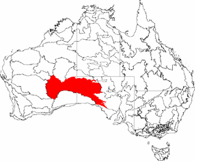 Map of the IBRA regions, with the Great Victoria Desert in red | |
| Ecology | |
| Realm | Australasian |
| Biome | Deserts and xeric shrublands |
| Borders | List
|
| Geography | |
| Area | 422,466 km2 (163,115 sq mi) |
| Country | Australia |
| States | South Australia and Western Australia |
| Conservation | |
| Conservation status | Relatively stable/intact |
| Protected | 129,367 km² (31%)[1] |
Location and description
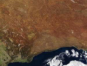
The Great Victoria is the largest desert in Australia[2] and consists of many small sandhills, grassland plains, areas with a closely packed surface of pebbles (called desert pavement or gibber plains) and salt lakes. It is over 700 kilometres (430 mi) wide (from west to east) and covers an area of 348,750 square kilometres (134,650 sq mi) from the Eastern Goldfields region of Western Australia to the Gawler Ranges in South Australia. The Western Australian mulga shrublands ecoregion lies to the west, the Little Sandy Desert to the northwest, the Gibson Desert and the Central Ranges xeric shrublands to the north, the Tirari-Sturt stony desert to the east, while the Nullarbor Plain to the south separates it from the Southern Ocean. Average annual rainfall is low and irregular, ranging from 200 to 250 mm (7.9 to 9.8 in) per year. Thunderstorms are relatively common in the Great Victoria Desert, with an average of 15–20 thunderstorms per annum. Summer daytime temperatures range from 32 to 40 °C (90 to 104 °F) while in winter, this falls to 18 to 23 °C (64 to 73 °F).
The Great Victoria desert is a World Wildlife Fund ecoregion and an Interim Biogeographic Regionalisation for Australia (IBRA) region of the same name.[3][4]
Habitation
The majority of people living in the region are Indigenous Australians from different groups including the Kogara, the Mirning and the Pitjantjatjara. Aboriginal populations have been increasing in this region. Young Indigenous adults from the Great Victoria Desert region work in the Wilurarra Creative programs to maintain and develop their culture.[5]
Despite its isolated location the Great Victoria is bisected by very rough tracks including the Connie Sue Highway and the Anne Beadell Highway.
Human activity has included some mining and nuclear weapons testing.[6]
History
In 1875, British explorer Ernest Giles became the first European to cross the desert. He named the desert after the then-reigning British monarch, Queen Victoria. In 1891, David Lindsey's expedition traveled across this area from north to south. Frank Hann was looking for gold in this area between 1903 and 1908. Len Beadell explored the area in the 1960s.
Flora
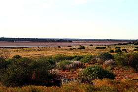
Only the hardiest of plants can survive in much of this environment. Between the sand ridges there are areas of wooded steppe consisting of Eucalyptus gongylocarpa, Eucalyptus youngiana and mulga (Acacia aneura) shrubs scattered over areas of resilient spinifex grasses particularly Triodia basedowii.
Fauna
Wildlife adapted to these harsh conditions includes few large birds or mammals. However, the desert does sustain many types of lizard including the vulnerable great desert skink (Egernia kintorei), the Central Ranges taipan (discovered in 2007), and a number of small marsupials including the endangered sandhill dunnart (Sminthopsis psammophila) and the crest-tailed mulgara (Dasycercus cristicauda). One way to survive here is to burrow into the sands, as a number of the desert's animals, including the southern marsupial mole (Notoryctes typhlops), and the water-holding frog do. Birds include the chestnut-breasted whiteface (Aphelocephala pectoralis) found on the eastern edge of the desert and the malleefowl of Mamungari Conservation Park. Predators of the desert include the dingo (as the desert is north of the Dingo Fence) and two large monitor lizards, the perentie (Varanus giganteus) and the sand goanna (Varanus gouldii).
Conservation and threats
As this area has had very limited use for agriculture, habitats remain largely undisturbed while parts of the desert are protected areas including Mamungari Conservation Park (formerly known as Unnamed Conservation Park) in South Australia, a large area of pristine arid zone wilderness which possesses cultural significance and is one of the fourteen World Biosphere Reserves[7] in Australia. Habitat is also preserved in the large Aboriginal local government area of Anangu Pitjantjatjara Yankunytjatjara in South Australia and in the Great Victoria Desert Nature Reserve of Western Australia.
The nuclear weapons trials carried out by the United Kingdom at Maralinga and Emu Field in the 1950s and early 1960s have left areas contaminated with plutonium-239 and other radioactive material.
External links
| Wikimedia Commons has media related to Great Victoria Desert. |
References
- Shephard, Mark (1995), The Great Victoria Desert : north of the Nullarbor, south of the centre, Reed Books, ISBN 978-0-7301-0485-8
- Joseph, Leo; Greenslade, Penelope; Barley, R. H. (Rachel); Nature Conservation Society of South Australia; Barley, Rachel (1986), The Great Victoria Desert, Nature Conservation Society of South Australia Inc, ISBN 978-0-949751-08-9
- Peppas, Lynn (2013), The Great Victoria Desert, St. Catharines, Ontario Crabtree Publishing Company, ISBN 978-1-4271-9100-7
- Friebe, Marlene; Matheson, W. E; South Australia. Department for Environment and Heritage; Friends of the Great Victoria Desert Parks (2006), Shrubs and trees of the Great Victoria Desert, Friends of the Great Victoria Desert Parks with the assistance of the Dept. for Environment and Heritage, ISBN 978-0-646-45948-6
- Friends of the Great Victoria Desert Parks (S.A.) (2007), Friends of the Great Victoria Desert, The Friends of the Great Victoria Desert Parks, retrieved 25 June 2017
Notes
- Dinerstein, Eric; Olson, David; et al. (June 2017). "An Ecoregion-Based Approach to Protecting Half the Terrestrial Realm". BioScience. 67 (6): 534–545. doi:10.1093/biosci/bix014.CS1 maint: date and year (link) Supplemental material 2 table S1b.
- Great Victoria Desert – The Largest Desert in Australia. Birgit Bradtke. Retrieved 26 March 2013.
- IBRA Version 7 data
- "Great Victoria desert". Terrestrial Ecoregions. World Wildlife Fund.
- Wilurarra Creative 2011;
- "Southern Australia". World Wildlife Fund. Retrieved 21 October 2015.
- Australia's Biosphere Reserves. Department of Sustainability, Environment, Water, Populations and Communities. Retrieved 3 May 2015.